Walk 2837 - printer friendly version
Parkhouse & Chrome Hills from Longnor Walk
Author - Lou Johnson
Length - 6.7 miles / 10.9 km
Ascent - 1250 feet / 379 metres
Grade - easy/mod
Start - OS grid reference SK065665
Lat 53.1955440 + Long -1.9041640
Postcode SK17 0RH (approx. location only)
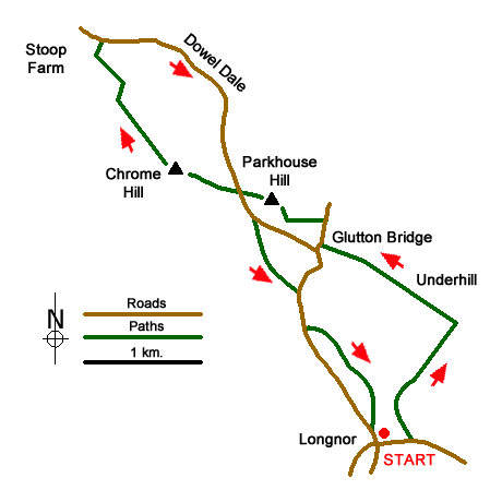
A Peak District walk in the upper Dove Valley that includes Parkhouse and Chrome Hills starting from the Staffordshire village of Longnor. With easily recognisable outlines, these hills are formed from the remains of a coral reef. Until recently, an ascent of Parkhouse Hill was not possible as it was private property. However, the hill is now open access land with freedom to roam.
The start is the market square in Longnor (grid ref. SK088649) where adequate parking is usually available. Walk east along the High Street (signed to Crowdicote, Sheen and Bakewell). Continue past the Olde Cheshire Cheese Inn on your left to reach a lane on the left - Top of th' Edge. Continue along the lane to the end. Take the bridleway through the metal gate on the right (grid ref. SK090650). Follow the concrete track downhill towards the Sewage Works as far as a barn on the left where the concreate track curves to the right. Go left in front of the barn and then right through a gate to Beggar's Bridge over the River Dove and into Derbyshire. Keep straight ahead to reach an access driveway to Underhill.
Turn left and follow the clear route through the buildings at Underhill and onto a lane (grid ref. SK087664). Continue straight ahead along the lane to reach the B5053 at Glutton Bridge. Turn right along this road taking care with traffic. After 200 metres, take the signed footpath on the left across a field. A path comes in from the right and you soon go through a cross-wall (grid ref. SK081667) to enter an open grassy area with Parkhouse Hill on your right.
I will not attempt to describe the ascent route. My route followed sheep trods and paths heading up the east ridge of the hill. This saves a very steep direct ascent up the southern flank of the hill. I then made my way up the ridge and spent some time enjoying the view which includes Chrome Hill and the upper Dove Valley. My descent followed the west ridge zigzagging where necessary on the steep descent to reach an un-fenced road (grid ref. SX077670).
Bear left along the tarmac lane for a short way. On your left, just before a cattle grid, a signed path leads you onto the permissive footpath for an ascent of Chrome Hill. The climb is steep in places with improving view. From the summit, you get a great retrospective view of Parkhouse Hill. Continue by descending the north-western ridge with the path twisting and turning between limestone outcrops. The path is way-marked and leads you across the eastern flanks of Tor Rock to reach the Stoop Farm access road (grid ref. SK064682).
Turn left to a lane. Turn right and follow the lane through Dowel Dale for about two kilometres reaching the cattle grid where you previously left the lane to climb Chrome Hill. 300 metres beyond the cattle grid is a footpath sign on the right (grid ref. SK078668). Go through the small gate, head half left across the field and cross a footbridge over the River Dove. The path then climbs quite steeply uphill to join a driveway, which is followed to the B5053.
Turn right along the road. There is no pavement so please be careful. After 250 metres (grid ref. SK082659), turn left down a track leading to Yewtree Grange. Stay on the concrete past this farm. Just after the last barn bear right onto a rougher track and follow this to a large farm building adjacent to a junction of tracks (grid ref. SK086655). Take the left-hand fork towards Underhill Farm (yes there are more than one!). After 150 metres, go right following a path climbing across the escarpment, which leads back to Lane Head and the centre of Longnor village.
Messaging & Social Media
Message Walking Britain and follow the latest news.

Mountain Weather
Stay safe on the mountains with detailed weather forecasts - for iOS devices or for Android devices.