Walk 2920 - printer friendly version
Egypt Bay & St Mary's Bay from High Halstow Walk
Author - Lou Johnson
Length - 7.5 miles / 12.2 km
Ascent - 150 feet / 45 metres
Grade - easy
Start - OS grid reference TQ781757
Lat 51.4522700 + Long 0.5618593
Postcode ME3 8TQ (approx. location only)
The Thames estuary is often seen as a desolate area despite being close to many large centres of population. This may be true but it is also home to a variety of sea birds who thrive on the mud banks. It is also an area that offers some peace and quiet and this walk does offer solitude and wide open skies.
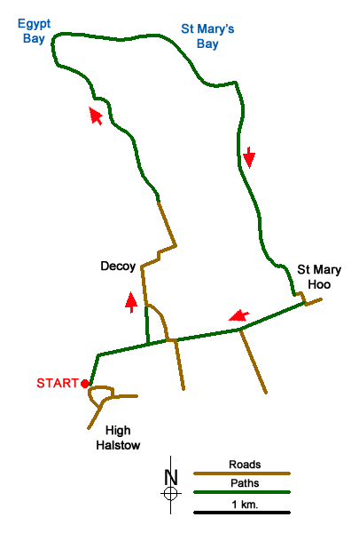
The start is the parking are at Woodside on the north-western edge of the village of High Halstow (grid ref. TQ781757). High Halstow is just to the north of the A228 which leads to the Isle of Grain. From the car park return along Woodside and turn left into Northwood Avenue. After just under 200 metres take the footpath on your left between houses to reach a field. Continue half right to the edge of the woodland (grid ref. TQ782760). Turn right onto the Saxon Shore Way and after 400 metres and a yellow waymark turn left. The path initially runs along the side of a field before entering woodland and continues to Decoy Hill Road (grid ref. TQ786765).
Turn left along the road and go right in front of Decoy Farm and continue on the lane until you reach Swigshole (grid ref. TQ788775) where the surfaced lane ends. Continue ahead on a clear track (manor Way) in a northerly direction for approximately 1.5 km to reach Egypt Bay (grid ref. TQ777790) and the southern shore of the Thames Estuary. Turn right (with the estuary on your left) and follow the shoreline path along the sea wall to St Mary's Bay and a clear path junction (grid ref. TQ795787).
Turn right here and continue south to St Mary Hoo, a pretty hamlet with its own church. Bear left around Ross Farm and follow the road as it bends to the right. The road soon bends left. Here take the track on your right and continue in a westerly direction to Newlands farm (grid ref. TQ796763). From here take the track continuing in a westerly direction (ignoring the tarmac lane heading south). This track continues along the field edges towards Decoy Hill Road (grid ref. TQ789762). (The final section of this path is Saxon Shore Way). Bear right along the road and take the first signed path on your left just after the lane bends right. This is a continuation of the Saxon Shore Way and this is followed to the edge of the woods first encountered at the beginning of the walk. Bear left across the field to the enclosed path leading onto Northwood Avenue. Turn right and retrace your steps back to the parking area.
Messaging & Social Media
Message Walking Britain and follow the latest news.

Mountain Weather
Stay safe on the mountains with detailed weather forecasts - for iOS devices or for Android devices.