Yr Elen from Gerlan
Snowdonia/Eryri Walk
Nat Park - Snowdonia - Western Carneddau
County/Area - Gwynedd
Author - Lou Johnson
Length - 6.5 miles / 10.6 km Ascent - 2820 feet / 855 metres
Time - 6 hours 0 minutes Grade - hard
Maps 

| Ordnance Survey Explorer OL17 | Sheet Map | 1:25k | BUY |
| Anquet OS Explorer OL17 | Digital Map | 1:25k | BUY |
| Ordnance Survey Landranger 115 | Sheet Map | 1:50k | BUY |
| Anquet OS Landranger 115 | Digital Map | 1:50k | BUY |
Walk Route Description
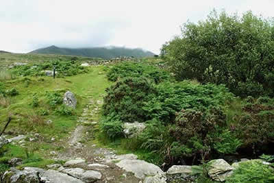
Click image to visit gallery of 9 images.
Topping 3000 feet, Yr Elen is the twelfth highest peak in Wales yet it is rarely features as the objective of a walk usually being included as part of a longer round over Carnedd Llewelyn to which it is connected by a ridge. It is worth warning that this walk covers some pathless territory, includes an airy ridge with some scrambling and could be impossible to complete if the rivers are in spate. It is also worth noting that it would be difficult to complete the walk with dry feet unless you have decent gaiters. That said it is a great route and apart from the summit of Yr Elen you are likely to have the mountains to yourself. An alternative route to the summit is featured in walk 3052.
The start of this Snowdonia (Eryri) walk is a small lay-by (Grid ref. SH637660) at the end of the lane running south-east from the village of Gerlan, which is located to the east above Bethesda. Should this space be full then further limited parking can be found further back to Gerlan adding about a mile to the distance. After parking cross the bridge over the Afon Lafar to take the signed right of way heading past the water works and along its southern bank towards the Carneddau.
You climb steadily with the view ahead including the northern flanks of the Carneddau with Yr Elen clearly in view (except on the day this walk was researched!) when only the lower slopes were below the cloud. You reach 'open country' (Grid ref. 648654) where you continue on the path to reach an isolated cast-iron railing. Descend left to cross the Afon Lafar, which, if in spate will be difficult, to gain the northern bank. Head just east of north across boggy ground and grass aiming for the sheepfold (Grid ref. 656661), which remains unseen until you have crested the north-western ridge of Yr Elen.
From the sheepfold contour east trying not to lose height to reach the south bank of the Afon Caseg. The going is pathless and you will encounter some more boggy areas so just grit your teeth and keep going! Having reached the Afon Caseg you will be able to use sheep trods and make better progress upstream. The valley narrows as you gain height and as the route turns south you will reach the small tarn of Ffynnon Caseg, which is beautifully located with the crags of Yr Elen soaring upwards above you.
The onward route needs care and should only be completed if you can see where you are going. From the small ruin on the northern shore of Ffynnon Caseg head north-north-west up the ill-defined ridge towards the crags above. The going is steep over grass and stones. You are probably unlikely to locate the feint path so just take care and if in doubt trend north to reach the foot of rockier terrain clearly in view above. Here you should be able to find the narrow path that leads through the crags with some scrambling up the east ridge of Yr Elen to reach the summit plateau.
After enjoying the view the descent leads north from the cairn, dropping steeply through rocky terrain onto the north-western ridge. After the initial descent the going gets easier and keeping south of Foel Ganol you descend over grass to cross boggy ground to reach Afon Lafar. Cross where convenient and head back down the path to the start.
Other walks nearby
| Walk 2115 | Yr Elen, Carnedd Llewellyn & Carnedd Dafydd | hard | 9.5 miles |
| Walk 2558 | Carnedd Dafydd & Pen yr Ole Wen from Bethesda | mod/hard | 8.0 miles |
| Walk 1074 | The Glyders Traverse | very hard | 12.0 miles |
| Walk 2833 | Moel Faban, Gyrn & Moel Wnion from Rachub | easy/mod | 5.0 miles |
| Walk 1315 | Drosgl and Gyrn Wigau from Rachub | moderate | 7.5 miles |
| Walk 1453 | Elidir Fawr, Mynydd Perfedd & Marchlyn Mawr reservoir | moderate | 6.0 miles |
| Walk 1088 | Glyder Ridge traverse | hard | 5.5 miles |
| Walk 1186 | Y Garn | mod/hard | 4.5 miles |
| Walk 3019 | Y Garn & Carnedd y Filiast Ogwen Cottage | hard | 8.5 miles |
| Walk 3062 | Pen yr Ole Wen | moderate | 5.0 miles |
Recommended Books & eBooks
Snowdonia: 30 Low-level and easy walks - South
 Guidebook describing 30 walks in Snowdonia, Wales. Routes are mostly low level and on clear paths and showcase the region's beautiful scenery and rich history and culture. Part of a 2-volume set, this southern volume includes Trawsfynydd, Bala, Dolgellau, Machynlleth, the Harlech Coast and the valleys of the Mawddach and Dyfi.
More information
The Wales Coast Path
 A single guidebook to walking the whole Wales Coast Path - 1400km (870 miles) the length of Wales from Chester to Chepstow, including Anglesey, described in 57 stages. The route passes through the Snowdonia and Pembrokeshire National Parks and many AONBs and can be linked with the Offa's Dyke Path for a complete circuit of Wales.
More information
Messaging & Social Media
Message Walking Britain and follow the latest news.

Mountain Weather
Stay safe on the mountains with detailed weather forecasts - for iOS devices or for Android devices.