Walk 3288 - printer friendly version
Ben Vrackie from Moulin (Pitlochry) Walk
Author - Lou Johnson
Length - 5.0 miles / 8.1 km
Ascent - 2200 feet / 667 metres
Grade - moderate
Start - OS grid reference NN944598
Lat 56.717894 + Long -3.7269653
Postcode PH16 5JN (approx. location only)
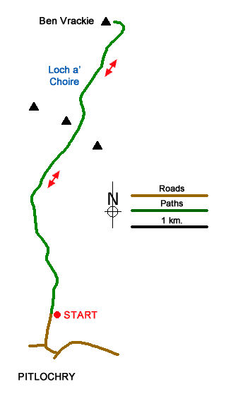
This walk climbs to the summit of Ben Vrackie (841 m.) from Moulin on the northern outskirts of Pitlochry. Ben Vrackie lies just south of the Cairngorm National Park. The route follows a clear and well-maintained path which is used by most walkers visiting the summit, which offers extensive views as far as Rannoch Moor and the Glencoe area.
The start is the upper car park (grid ref. NN994598) which is signed from the Moulin Hotel just to the north of Pitlochry. On busy days you may need to use the lower car park. The route which is signed from the car park and at intermediate path junctions heads north through pleasant woodland initially following Moulin Burn.
Reaching open hillside, you pass a notice reminding you to be properly equipped for this mountain walk. Note that as with many hill walks the weather can change quickly. The onward path crosses heather moors gaining height steadily. Reaching the junction with the Bealach Path (grid ref. NN943614), bear right here and continue up to a bealach between the minor summits of Creag Bhreac on your right and Stac an Fheidh on your left.
After the bealach you lose a little height before continuing to climb past Loch a' Choire. After crossing the dam, the gradient steepens, and the hard work begins. The path is good, and you climb quickly with the southern flank of Ben Vrackie ahead. Eventually the path curves left, and the summit is nearby. Continue the short distance to the summit and enjoy the views. The summit area is adorned with an OS trig column and a topograph which details the landmarks visible from the summit.
The descent route follows the path used to reach the summit. However, a worthwhile diversion is to bear left off the main path shortly after leaving the summit to a cairn from where a different perspective of the view can be enjoyed.
Messaging & Social Media
Message Walking Britain and follow the latest news.

Mountain Weather
Stay safe on the mountains with detailed weather forecasts - for iOS devices or for Android devices.