Porth y Nant & Nant Gwrtheryn Circular Walk
Walk 3374 - Route Maps & Profile
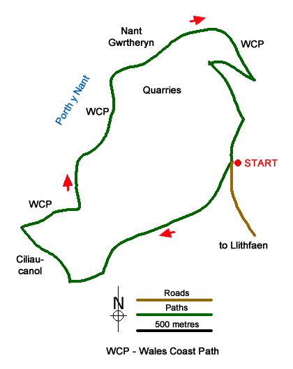
Route Map
Digital Maps - Copyright © 2011-2024. All rights reserved.
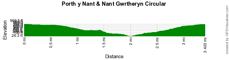
Route Profile
Sketch Map
Suggested Maps 

| Ordnance Survey Explorer 253 | Sheet Map | 1:25k | BUY |
| Anquet OS Explorer 253 | Digital Map | 1:25k | BUY |
It is recommended you take a map. The preferred scale is 1:25k.
Start Point Details
Ordnance Survey Grid Ref SH353440
Latitude 52.967993 Longitude -4.453934
Postcode LL53 6NU
what3words start mainframe.link.shift
Walk description may contain detailed information on the start point for this walk.
Further Information
Llyn Peninsula
In 1956, a large part of the Llŷn Peninsula was designated an Area of Outstanding Natural Beauty under the National Parks and Access to the Countryside Act 1949. It is now a National Landscape. It is one of only five such areas in Wales. The logoshows a Chough as this bird favours the peninsula's rocky coastline where there are around 60 nesting pairs. The Llŷn Peninsula AONB covers 155 square kilometres with approximately 70% of the area's population speaking Welsh. Llyn Peninsula Walking Guide
Walk grading - Learn how each walk is assessed and select a walk to suit your ability and experience by going to Walk Grading Details.
Messaging & Social Media
Message Walking Britain and follow the latest news.

Mountain Weather
Stay safe on the mountains with detailed weather forecasts - for iOS devices or for Android devices.