Silver How from Grasmere
Lake District Walk
Nat Park - Lake District - Lake District Central Fells
Wainwrights - Silver How
County/Area - Cumbria
Author - Lou Johnson
Length - 3.2 miles / 5.2 km Ascent - 900 feet / 273 metres
Time - 2 hours 30 minutes Grade - easy
Maps 

| Ordnance Survey Explorer OL7 | Sheet Map | 1:25k | BUY |
| Anquet OS Explorer OL7 | Digital Map | 1:25k | BUY |
| Ordnance Survey Landranger 90 | Sheet Map | 1:50k | BUY |
| Anquet OS Landranger 90 | Digital Map | 1:50k | BUY |
Walk Route Description
Click image to see photo description.
This half day walk from Grasmere provides some excellent views to Grasmere and Rydal Water as well as a wider panorama to the higher Lake District fells including Bowfell, the Langdale Pikes and Crinkle Crags. The route follows well-used paths although the area traversed can be confusing in poor visibility, so you are encouraged to take a 1:25k OS map.
The start is the pay and display Red Bank carpark (grid ref. NY336074). There are other parking options elsewhere but this one if the most convenient. After parking cross Red Bank Road and take Broadgate Road opposite (signed to Keswick). After 200 metres you reach a road junction. Just before the junction turn left up a narrow road with a 'no public parking beyond this point' sign. This leads to Hallam Bank, which is a National Trust property. Go through the gate and follow the drive. Where the drive forks, go right and continue following the track.
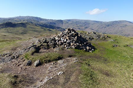
Turn left following the fingerpost to Silver How and Langdale. The track soon becomes a stony path to reach a gate. Continue along the path to another gate. Staying on the path you pass a large cairn and beyond this you reach a fork (grid ref. NY325073). Bear left here and descend to cross Wray Gill. The cairned path climbs steadily over the fell heading south. To reach the summit of Silver How with its prominent cairn.
After enjoying the extensive view descend southeast to reach a large cairn. From here the descent steepens. Follow the clear path to reach a path crossroads adjacent to a wall (grid ref. NY327064). Turn left (with wall on your right) following a grassy path. You pass through three gates. After the third gate the path is enclosed between walls and leads down to the road. Turn left along the road back to the start.
Other walks nearby
| Walk 1154 | Between Grasmere and Langdale | moderate | 9.5 miles |
| Walk 1472 | Alcock Tarn & Rydal Water | easy/mod | 7.0 miles |
| Walk 1565 | Rydal Water & Grasmere circular | easy/mod | 6.0 miles |
| Walk 1682 | Rydal Water & Grasmere | easy/mod | 5.5 miles |
| Walk 1111 | High Raise & Helm Crag | mod/hard | 9.5 miles |
| Walk 2254 | Grisedale Tarn | moderate | 5.5 miles |
| Walk 2841 | Seat Sandal via Grisedale Tarn from Grasmere | moderate | 5.0 miles |
| Walk 2932 | Green Burn horseshoe from Grasmere | moderate | 7.0 miles |
| Walk 1823 | Fairfield Horseshoe & Loughrigg from High Close | mod/hard | 14.0 miles |
| Walk 2715 | Skelwith Bridge & Loughrigg | easy/mod | 5.5 miles |
Recommended Books & eBooks
Lake District: High Level and Fell Walks
 This guidebook describes 30 graded fell walks on the ridges and high peaks of the English Lake District, the UK's most popular national park. Reaching some of England's finest and highest mountain scenery, this guide leads readers to classic horseshoes and traditional ascents as well as lesser-known routes to quieter summits.
More information
Walking the Lake District Fells - Keswick
 Part of the Walking the Lake District Fells series, this guidebook covers a wide range of routes to 30 Lakeland summits that can be climbed from Keswick, Whinlatter, Bassenthwaite, Caldbeck, Mungrisdale and Threlkeld, with highlights including Skiddaw and Blencathra. Includes suggestions for longer ridge routes.
More information
Messaging & Social Media
Message Walking Britain and follow the latest news.

Mountain Weather
Stay safe on the mountains with detailed weather forecasts - for iOS devices or for Android devices.