Walk 3738 - printer friendly version
Polzeath & Pentire Point from Rock Walk
Author - Lou Johnson
Length - 11.4 miles / 18.5 km
Ascent - 1400 feet / 424 metres
Grade - moderate
Start - OS grid reference SW928757
Lat 50.5442660 + Long -4.9258089
Postcode PL27 6FF (approx. location only)
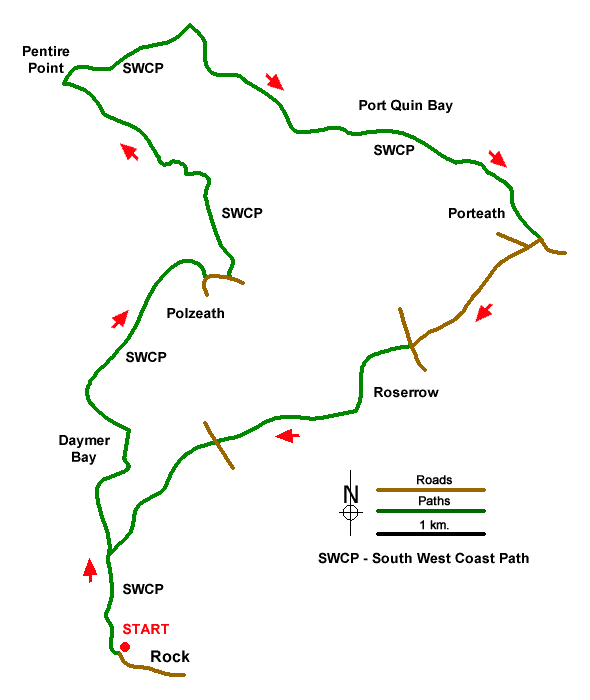
This Cornwall coastal walk starts from Rock on the Camel Estuary. The route follows the South West Coast Path past Brea Hill to reach Polzeath. The route continues along the coastal path to Pentire Point and along the cliffs at Port Quin Bay. The route then turns inland and uses country lanes and paths to cross the peninsula and return to the start. As with many coastal walks, the route is undulating with many ascents and descents.
The walk starts from the pay and display car park at the western end of the waterfront in Rock by the Rock Ferry slipway (grid ref. SW928757). After parking exit the western end of the car park and join the signed South West Coast Path (SWCP) with the Camel Estuary on your left. The path is generally well-signed and easy to follow. Reaching Brea House, keep left and pass Brae Hill which rises on your right. You can, if you wish, make a brief ascent before continuing along the SWCP. Cross a footbridge (grid ref. SW929774) and continue through the dunes at the back of Daymer Bay.
Reaching the car park for Daymer Bay, bear left and continue along the SWCP. The route continues past Trebetherick Point where it bears northeast along the Greenway to reach the sandy beach at Polzeath. Reaching the road in Polzeath, bear left and pass the large car park on your left. Turn left oat the fingerpost just past the Surf Shop (grid ref. SW937789) and bear right along the back of the car park. Join a walled lane and after 100 metres turn left along the SWCP. Continue north, joining a short section of road at Pentireglaze Haven. Where the main road turns right, turn left at the fingerpost to continue along the SWCP.
Continue northwest to reach Pentire Point where it is worth spending some time enjoying the view which extends from Trevose Lighthouse to the southwest and Tintagel Castle in the east. Follow the path and continue eastwards to The Rumps which was the site of an Iron Age fort. Follow the clear path past Com Head to reach the small beach at Lundy Bay to reach a footpath junction at Lundy Hole (grid ref. SW958798). Turn right and follow the steep path uphill which leads across several fields to reach the farm buildings at Portreath. Continue along the access drive to reach a road by the Bee Centre (grid ref. SW962792).
Turn left along the road (care needed) for 100 metres and bear left onto a lane signed to Mesmear Farm. Continue past this farm and after a further 800 metres reach a T-junction (grid ref. SW952783). Cross the road and take the footpath opposite up some stone steps. Cross a field to join a track. Turn left and follow the track as it bends sharp left. Turn right and pass the club house (on your right). Follow the path across the golf course (marked with white stones). Leaving the golf course, the path continues west across two fields, passes between houses and joins a road (grid ref. SW936776).
Cross the road to join another path (no fingerpost). The path crosses two fields and passes St. Enodoc's church (keep church to your right). The route then crosses another golf course (route marked with stones) to reach a footbridge (grid ref. SW930769). Cross the bridge and turn left and soon after bear right onto a short path that leads back to the SWCP. Bear left along the coast path (estuary on your right) and return to the start.
Messaging & Social Media
Message Walking Britain and follow the latest news.

Mountain Weather
Stay safe on the mountains with detailed weather forecasts - for iOS devices or for Android devices.