Green Lane on Little Combe Hill
Walk Photo 214601
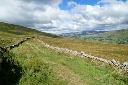
Caption - Green Lane is a public bridleway which traverses the northern slopes of Great Coum from a point just southwest of the high point of the Barbondale to Dentdale road at 285m asl, to a point similarly just north of the Dentdale to Kingsdale road at 465m asl. With a high point at 520m along the way, 235m seems a lot of ascent for a "traverse", but it is spread over about 8km so is in reality very gentle for a walk with such splendid views. By this point it has reached about 410m asl and is now traversing Little Combe Hill, the end of the north flank of Great Coum, and maintains the splendid view of the Howgill Fells which it has had over the last couple of kilometres. Dentdale can be seen below us to the right.
Walk 2146 : Deepdale Circular (near Dent)
Photographer : Andy Waddington
Use back button to return to the photo gallery lists.
Further Information
Location Map
Yorkshire Dales
Walking in the Yorkshire Dales National Park covers an extensive area, which contains a wide variety of scenic interest. Each Dale is usually named after its river although there are a few examples that don't follow this rule. The varied underlying geology is reflected in the scenery with limestone and gritstone the prominent rocks resulting in virtually every type of scenery from dry valleys to wild moorland. More Information
Messaging & Social Media
Message Walking Britain and follow the latest news.

Mountain Weather
Stay safe on the mountains with detailed weather forecasts - for iOS devices or for Android devices.