Snowdon by the Llanberis Path from Llanberis
Snowdonia/Eryri Walk
Nat Park - Snowdonia - Snowdon Crib Goch
County/Area - Gwynedd
Author - Lou Johnson
Length - 9.0 miles / 14.6 km Ascent - 3300 feet / 1000 metres
Time - 7 hours 50 minutes Grade - moderate
Maps 

| Ordnance Survey Explorer OL17 | Sheet Map | 1:25k | BUY |
| Anquet OS Explorer OL17 | Digital Map | 1:25k | BUY |
| Ordnance Survey Landranger 115 | Sheet Map | 1:50k | BUY |
| Anquet OS Landranger 115 | Digital Map | 1:50k | BUY |
Walk Route Description
Click image to visit gallery of 6 images.
The summit of Snowdon is a magnet for visitors. Some arrive by train from Llanberis whilst others reach the summit the hard way having walked their way to the top. There are a number of routes that lead to the summit of Snowdon and the Llanberis Path, although not the shortest, might be described as one of the easiest as it involves good clear paths and a steady ascent. Despite its relative ease, you should still ensure you are well equipped with good footwear, adequate food and drinks plus clothing to cater for worsening weather conditions.
The start of this walk is the Snowdon Mountain Railway Station in Llanberis (Grid ref. SH 582 598). Walk south along the main road and take the first road on your right. This leads you past some cottages/houses and the start of the Llanberis Path which leads to the summit. The road turns south and shortly after you take the signed path on the left (Grid ref. SH 582 590).
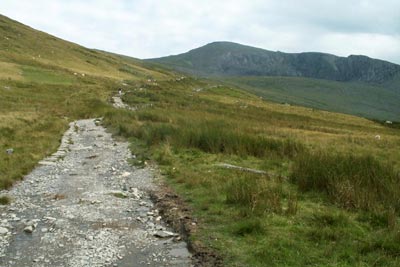
Follow this broad Llanberis Path as it climbs steadily. At this stage the summit (still out of sight) seems a long way off but the gradient is not too taxing and you make steady progress. Passing through a short tunnel under the railway you reach Halfway Station. The ascent continues, steepening somewhat just before Clogwyn Station where you cross to the other side of the track via an underbridge. You are now three-quarters of the way to the top and the next section seems uninteresting as you climb more steeply than the railway to reach the top of the Pyg Track.
The top is now in sight and all that remains is the easy final section to the summit cairn. On most days you will not be alone and there is usually a bustling atmosphere as people enjoy the view and celebrating the achievement of reaching the summit.
To return to the start retrace your steps down the Llanebris Path making sure you keep the railway on your left as far as Clogwyn Station, on your right until Halfway Station and on your left again for the remainder of the route. Refreshments can be obtained at the Summit when trains are operating. In winter extra care is needed as two or three sections of the route are subject to icing turning a straightforward summer route into a more dangerous proposition.
Other walks nearby
| Walk 2626 | Snowdon & Garnedd Ugain from Llanberis | moderate | 9.3 miles |
| Walk 3057 | Moel Eilio from Llanberis | moderate | 7.0 miles |
| Walk 3059 | Moel Cynghorion & Snowdon from near Llanberis | very hard | 13.5 miles |
| Walk 3613 | Moel Cynghorion from Llyn Cwellyn | moderate | 5.0 miles |
| Walk 1453 | Elidir Fawr, Mynydd Perfedd & Marchlyn Mawr reservoir | moderate | 6.0 miles |
| Walk 2590 | Nantlle Ridge Walk from Rhyd Ddu (Route A) | moderate | 6.0 miles |
| Walk 2797 | Yr Aran and Snowdon from Rhyd-Ddu | mod/hard | 8.5 miles |
| Walk 3509 | Nantlle Ridge from Rhyd Ddu (Route B) | mod/hard | 8.3 miles |
| Walk 3198 | Snowdon via the South Ridge & Rhyd-ddu Path | mod/hard | 7.5 miles |
| Walk 1951 | Mynydd Mawr from Rhyd-Ddu | moderate | 6.0 miles |
Recommended Books & eBooks
The Wales Coast Path
 A single guidebook to walking the whole Wales Coast Path - 1400km (870 miles) the length of Wales from Chester to Chepstow, including Anglesey, described in 57 stages. The route passes through the Snowdonia and Pembrokeshire National Parks and many AONBs and can be linked with the Offa's Dyke Path for a complete circuit of Wales.
More information
The Cambrian Way
 Guidebook to the Cambrian Way, a challenging three-week mountain trek through Wales from Cardiff to Conwy. The 470km un-waymarked route is presented from south to north. Often sticking to long, beautiful ridgelines, it crosses wild and rugged terrain and visits many of Wales's highest mountains, including Snowdon.
More information
Messaging & Social Media
Message Walking Britain and follow the latest news.

Mountain Weather
Stay safe on the mountains with detailed weather forecasts - for iOS devices or for Android devices.