Plynlimon & Nant-y-Moch Reservoir from Esteddfa Gurig
Cambrian Mountains Walk
Region - Cambrian Mountains
County/Area - Ceredigion
Author - Peter Lane
Length - 11.0 miles / 17.9 km Ascent - 2200 feet / 667 metres
Time - 7 hours 40 minutes Grade - hard
Maps 

| Ordnance Survey Explorer 213 | Sheet Map | 1:25k | BUY |
| Anquet OS Explorer 213 | Digital Map | 1:25k | BUY |
| Ordnance Survey Landranger 135 | Sheet Map | 1:50k | BUY |
| Anquet OS Landranger 135 | Digital Map | 1:50k | BUY |
Walk Route Description
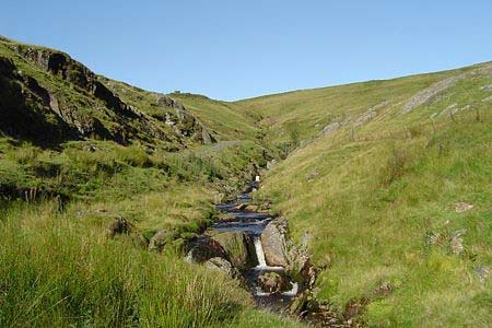
Click image to visit gallery of 12 images.
Plynlimon is the highest point in mid-Wales and also the high plateau watershed from which two major rivers: the Severn and the Wye derive their source. A wild and barren place, its desolation belies its relative accessibility. This spectacular walk across barren wilderness affords panoramic views that more than rival Snowdonia (Eryri), with the added bonus that practically nobody will be there to spoil your enjoyment of it. This walk is a serious undertaking suitable only for experienced hill walkers comfortable with finding routes across trackless wilderness. This route should not be attempted in poor visibility due to a lack of defined paths and landmarks on the high plateau. It is also recommended that the 1:25,000 Explorer map be used. The ground in this area can be boggy and treacherous, so poles are recommended for testing the ground ahead.
The start point for this walk is in the hamlet of Esteddfa Gurig at grid reference SN796840. The nearest roadside parking is up the A44 at SN799841. Although this requires a 300 metre walk to the start point, this is the most accessible parking. Enter the farmyard at the fingerpost and pass by a cage most likely filled with barking dogs. All the dogs were caged or tethered when I passed by, but be prepared just in case with a stick or pole. A metal gate marked "All Walks" at the time of writing ahead takes you to the side of a stream. Follow this along a well defined path initially going West and then turning North after a short while all the way up to some derelict mine workings.
Just before reaching the mine workings, the path turns off left (watch out for the waymark). The path deteriorates into little more than a sheep track in a very short space of time. Once you get close to the summit, the path becomes more distinct and cairns guide you to the summit of Pumlumon Fawr. A ladder stile crosses the fence and a dry stone walled refuge and trig point populate the summit. The views are truly magnificent and extend 360 degrees. At this point you must decide whether to go on or turn back. If visibility is poor, retrace back to the start, going on is not worth the risk.
Head for the next cairn ahead and enjoy the views from there and then follow the line of the fence that runs generally East to spot heights of 691m and 727m (Explorer map only). At the lowest point there is a small boggy lake to the left side of the fence, best avoided. Leave the fence where it turns the corner at a cairn at the 727m spot height. Head generally North now, towards some crags, keeping to the high ground until you cross the Nant y Graig-Ias gulley. The delightful reservoir Llyn Llygad Rheidol lies in the valley below. The Northern tip of this lake is your objective. Get down any way you can, generally following the North side of the gulley.
Reaching the reservoir, you will have to cross the outflow (Nant y Llyn). This should not present any difficulty, but requires a good sense of balance walking on the concrete strip where the lake overflows into the stream. This is not as bad as it sounds, the concrete provides good grip and the water is nothing more than a trickle. At worst, you can only fall a couple of feet and get a boot full of water. Once safe on the other side, follow the reservoir access road back to relative civilisation, but pause first to drink in the magnificent views to Pumlumon Fawr.
The reservoir road contours around Pumlumon Fach and emerges onto a beautiful minor road on the banks of Nant-y-Moch reservoir. Turn left on this road, pass a pumping station (a prospective alternate start point) at SN764867 and then uphill to a crossroads. Continue left and downhill with some magnificent views of the dam. Upon reaching Lle-r-neuaddau farm, cross the cattle grid and just up the incline past the farm there is a well made track heading to Dyll Faen wood.
The OS maps show a RUPP (Road Used as a Public Path) joining the track and heading off through the woods. Do not be deceived. The RUPP is no more than a small footpath at best. Through one metal gate, head down towards the wood and a stream. Take care now, it is easy to be lulled by your map into the thought that the wide track continues right through the forest - it does not. In order to stay on the right of way, you will have to turn right at the stream and follow it for about 300 metres before entering the wood at a waymark. This track should eventually emerge on the East side of the wood.
This is easily missed - I know, because I missed it due to being chased by some over-friendly puppies ever since the farm! If you miss it, don't despair - continue on the broad track through another metal gate into the woods until the track terminates. Continue East in the clearing following the telegraph poles in the valley all the way to the fence at the East side of the wood. Extreme caution is required. There is a stream in the middle of the valley, often heard but not seen. One wrong step could place you in serious trouble, keep to the tops of the tussocks or better still, stay away from the bottom of the valley.
Eventually you will emerge at a fence running North-South and whichever path you've taken through the wood, they will be only 20 metres apart now. Cross the fence (via the stile if you've successfully negotiated the right of way) and head down the hill past the old mine to the start point.
Other walks nearby
| Walk 2048 | Craig-y-Pistyll, Cambrian Mountains | moderate | 10.0 miles |
| Walk 3086 | Pen y Garn from near Devil's Bridge | easy/mod | 6.8 miles |
| Walk 1705 | Bont-goch Circular from near Aberystwyth | easy/mod | 4.5 miles |
| Walk 1898 | Severn Valley from Llanidloes | moderate | 11.3 miles |
| Walk 2736 | Teifi Pools from near Strata Florida | easy/mod | 6.2 miles |
| Walk 1365 | Strata Florida to Tregaron | moderate | 9.5 miles |
| Walk 1420 | Borth to Aberystwyth coast | easy/mod | 6.5 miles |
| Walk 3297 | Crugyn Ci, Esgair Perfedd & Penygarreg - Elan Valley | moderate | 7.5 miles |
| Walk 1363 | The Elephant Walk from Tregaron | easy/mod | 5.5 miles |
| Walk 3317 | Happy Valley Circular | easy | 4.2 miles |
Recommended Books & eBooks
The Wales Coast Path
 A single guidebook to walking the whole Wales Coast Path - 1400km (870 miles) the length of Wales from Chester to Chepstow, including Anglesey, described in 57 stages. The route passes through the Snowdonia and Pembrokeshire National Parks and many AONBs and can be linked with the Offa's Dyke Path for a complete circuit of Wales.
More information
Messaging & Social Media
Message Walking Britain and follow the latest news.

Mountain Weather
Stay safe on the mountains with detailed weather forecasts - for iOS devices or for Android devices.