Pole Bank (Long Mynd) from Carding Mill
Shropshire Hills Walk
Region - Shropshire Hills
County/Area - Shropshire
Author - Lou Johnson
Length - 6.5 miles / 10.6 km Ascent - 1205 feet / 365 metres
Time - 4 hours 30 minutes Grade - moderate
Maps 

| Ordnance Survey Explorer 217 | Sheet Map | 1:25k | BUY |
| Anquet OS Explorer 217 | Digital Map | 1:25k | BUY |
| Ordnance Survey Landranger 137 | Sheet Map | 1:50k | BUY |
| Anquet OS Landranger 137 | Digital Map | 1:50k | BUY |
Walk Route Description
Click image to visit gallery of 5 images.
Shropshire is often ignored yet it provides plenty of fine walking with many hills and interesting areas of high ground. One of the most popular areas is the Long Mynd with the summit of Pole Bank (516 m - 1692 ft) forming a good excuse to explore the area. Basically a large plateau there are many deep valleys and these form a radial pattern into the moorland. Although the area is ideal for those wanting to make their first excursion into the hills navigation can be difficult and care is advised even in good weather.
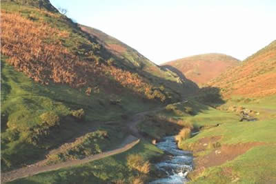
This walk starts in Carding Mill Valley. This popular "beauty spot" is well signed from Church Stretton and to make the best of your visit an early start to avoid the crowds is advised. There is plenty of parking available either before the National Trust tea-room or as on this occasion you can drive as far as possible up the valley going past the tea-room to the small parking area (grid ref. SO441948).
Follow the main path westwards up the valley taking the right fork at the first major valley junction (grid ref. 435951). This path climbs steadily onto the plateau. Care is needed as there are many paths criss-crossing this whole area and reaching "the Portway" (an ancient pack horse route) at grid ref. 427957 turn left and head south west veering towards south to reach the trig point on Pole Bank crossing a road on the way.
From here the views are excellent with a wide panorama to the west including much of Central Wales. The nearest hills however are the Stiperstones, another area of Shropshire high ground that is worth a visit. Luckily the summit of Pole Bank is adorned with a brass plaque that usefully points out all the major mountains and hills that are visible on a fine day!
To continue the walk you will need to retrace your steps a short way before heading east to reach the road near the "Boiling Well" (grid ref. 422945). Continue on the grass beside the road towards Church Stretton as it descends gently. After half a kilometre you will reach a clear broad path on your right heading roughly south (grid ref 430943). Take this path as it curves in a large arc and begins to head east. If you reach the road again you have gone too far and will need to retrace your steps. After leaving the road, the first valley on your right is Ashes Hollow but as the path swings east you will see Townbrook Valley, a deep sided valley with occasional rocky outcrops. Care is needed to pick up the path that leads steeply down into Townbrook Valley. Once located follow it as it drops to run alongside the stream soon reaching a wood (grid ref. 446938). Do not enter the wood but turn left and follow the path heading north to reach the road (grid ref. 447938). Cross the road and descend on a path that descends northwest into Carding Mill Valley and the start of the route.
Other walks nearby
| Walk 3308 | Ragleth and the Long Mynd | mod/hard | 11.0 miles |
| Walk 3449 | Ragleth, the Long Mynd & Ratlinghope | hard | 18.0 miles |
| Walk 1374 | Lightspout Waterfall and Pole Bank | easy/mod | 5.8 miles |
| Walk 1321 | Caer Caradoc & Hope Bowder Hill | moderate | 9.0 miles |
| Walk 3048 | Caer Caradoc & The Lawley | moderate | 10.0 miles |
| Walk 1097 | Caer Caradoc | easy/mod | 3.5 miles |
| Walk 1844 | The Portway & Betchcott Hill from Picklescott | easy/mod | 5.0 miles |
| Walk 2745 | Betchcott Hills & Pole Bank | moderate | 9.0 miles |
| Walk 1205 | Adstone Hill, Medlicott and the Long Mynd | moderate | 9.5 miles |
| Walk 2054 | Linley Hill & Beeches from Wentnor | easy/mod | 7.0 miles |
Recommended Books & eBooks
Hillwalking in Shropshire
 Guidebook to 32 walking routes in Shropshire in the West Midlands. The routes range from 3 miles (5km) to 12 miles (19km), taking in highlights such as The Wrekin, Wenlock Edge, Long Mynd and Stiperstones, Castle Ring and Bury Ditches. Many routes start near delightful towns and villages including Church Stretton, Ludlow and Bishops Castle.
More information
Messaging & Social Media
Message Walking Britain and follow the latest news.

Mountain Weather
Stay safe on the mountains with detailed weather forecasts - for iOS devices or for Android devices.