Stoodley Pike from Hebden Bridge
South Pennines Walk
Region - South Pennines
County/Area - West Yorkshire - South Pennines
Author - Lou Johnson
Length - 11.0 miles / 17.9 km Ascent - 1500 feet / 455 metres
Time - 7 hours 0 minutes Grade - moderate
Maps 

| Ordnance Survey Explorer OL21 | Sheet Map | 1:25k | BUY |
| Anquet OS Explorer OL21 | Digital Map | 1:25k | BUY |
| Ordnance Survey Landranger 103 | Sheet Map | 1:50k | BUY |
| Anquet OS Landranger 103 | Digital Map | 1:50k | BUY |
| Ordnance Survey Landranger 104 | Sheet Map | 1:50k | BUY |
| Anquet OS Landranger 104 | Digital Map | 1:50k | BUY |
Walk Route Description
Click image to visit gallery of 6 images.
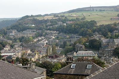
The South Pennines are home to some attractive hills and moorland dissected by industrialised valleys. The large monument on Stoodley Pike, the main objective of this walk, is well known to Pennine Way walkers as it dominates the landscape from a considerable distance.
The walk starts in Hebden Bridge with its attractive terraced houses and a variety of shops. After parking near the centre of Hebden Bridge (Grid ref. SD992272), locate Holme Street and walk south past the theatre. Cross the Rochdale Canal and follow the towpath west over the River Calder to turn left up some steps to a road. Turn left along the road across the railway and take the first track on the right to climb south-eastwards into woodland. At the first junction turn right and continue climbing through the woods to reach a radio mast (Grid ref. 988272).
Cross the lane and take the stile opposite. The path takes you steadily uphill and through fields to reach a lane (Grid ref. SD 986263). Go straight across and continue along Pinnacle Lane. This lane is followed south to reach the Pennine Way (Grid ref. SD 978250). Turn left along the Pennine Way to the monument on Stoodley Pike.
Leave the monument and walk south along the clear path that follows the edge of the escarpment. After dropping down to the market stone at Withens Gate turn left and follow the Calderdale Way to the dam of Withens Clough Reservoir. (Note there are many alternative paths that all lead to the dam).
Follow the road and descend to the small car park. Take the left fork and follow the tarmac track as it climbs gently. Fork right at the next junction continuing on the track past High Green. Short cut across the moorland to Keelham and then contour across Bell House Moor negotiating some wet sections on the way. Where the paths diverge (Grid ref. SD 993247) you should bear right and continue across open moor to reach Broad Head.
Turn right down a walled lane to Daisy Bank. Just after leaving the small area of woodland, turn left over a stile and cross fields to reach a lane opposite some cottages (Grid ref. SE 003258). Turn left along this lane and continue to Wood Top. Bear left along a further track to enter a wood. The path continues and rejoins the outward route. Retrace your steps along the Rochdale Canal and into the centre of Hebden Bridge.
Other walks nearby
| Walk 2121 | Crimsworth Dean, Lumb Bridge & Hardcastle Crags | moderate | 7.5 miles |
| Walk 1626 | Luddenden Foot Circular | easy/mod | 7.5 miles |
| Walk 3015 | Stoodley Pike & Withens Clough Reservoir from Lobb Mill | moderate | 9.0 miles |
| Walk 1057 | Luddenden Dean and the Calderdale Way | easy/mod | 6.5 miles |
| Walk 1411 | Walsden & Warland Reservoir | easy/mod | 6.5 miles |
| Walk 1336 | Sowerby Bridge and Norland Moor | easy/mod | 7.0 miles |
| Walk 1584 | Ogden Reservoir | easy | 4.0 miles |
| Walk 2705 | Oxenhope to Hebden Bridge without a car | moderate | 11.0 miles |
| Walk 1307 | Circuit of Ovenden Moor from Oxenhope | moderate | 8.0 miles |
| Walk 3719 | Ramsden Wood & Hades Hill from Walsden | easy/mod | 6.1 miles |
Recommended Books & eBooks
The Pennine Way - the Path, the People, the Journey
 A portrait of the The Pennine Way, Britain's oldest and best known long-distance footpath, stretching 268 miles from the Peak District to the Scottish Borders. This personal, thoughtful and often humorous story of the path's remarkable history, includes the experiences of walkers and local characters on this exhilarating and complex path.
More information
Pennine Way Map Booklet
 Map of the 270 miles (435km) Pennine Way National Trail, between Edale in the Peak District and Kirk Yetholm in the Scottish Borders. This booklet is included with the Cicerone guidebook to the trail, and shows the full route on Ordnance Survey 1:25,000 maps. This popular long-distance route typically takes three weeks to complete.
More information
Messaging & Social Media
Message Walking Britain and follow the latest news.

Mountain Weather
Stay safe on the mountains with detailed weather forecasts - for iOS devices or for Android devices.