Low Bradwell & Agden Reservoir
Peak District Walk
Nat Park - Peak District - Derwent Edge Sheffield
County/Area - South Yorkshire
Author - Yorkshire Water
Length - 3.5 miles / 5.7 km Ascent - 300 feet / 91 metres
Time - 2 hours 0 minutes Grade - easy
Maps 

| Ordnance Survey Explorer OL1 | Sheet Map | 1:25k | BUY |
| Anquet OS Explorer OL1 | Digital Map | 1:25k | BUY |
Walk Route Description
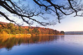
Click image to see photo description.
This walk lies within the boundary of the Peak District National Park and offers and interesting look at the local countryside with Agden Reservoir providing a focus for this walk. Located to the north-west of Sheffield the route includes sections of woodland and waterside walking together with some open countryside. The quaint villages of High and Low Bradfield can also be explored.
This is one of the free reservoir walks produced by Yorkshire Water who are one of the county's largest landowners, with around 72,000 acres of land spanning National Parks, Areas of Outstanding Natural Beauty, the North York Moors and the Yorkshire Wolds. There is a wide range of walks on offer from gentle strolls around one of their picturesque reservoirs to more adventurous routes. Yorkshire Water have selected some of their top walks for you and split them into three regional packs. Just print them out and off you go.
Each site has its own walk pack that you can easily print out and take along with you. Each pack includes directions to the site, a summary of the walk, a list of facilities available, a detailed route map and route instructions. To download walk descriptions go to Yorkshire Water Walks.
Other walks nearby
| Walk 1578 | Dale Dike Reservoir | easy | 2.5 miles |
| Walk 1579 | Damflask Reservoir | easy | 3.5 miles |
| Walk 1285 | Dungworth & Rod Moor | moderate | 9.4 miles |
| Walk 1522 | Back Tor, Bradfield Moors and Reservoirs | moderate | 11.0 miles |
| Walk 1687 | Broomhead & Howden Moors | moderate | 12.4 miles |
| Walk 3439 | High Bradfield from Glen Howe | moderate | 8.3 miles |
| Walk 2516 | Moscar, Dale Dike & Shrines Reservoirs | easy/mod | 7.0 miles |
| Walk 2629 | Stanage Edge, Redmires & Hallam Moors | easy/mod | 8.5 miles |
| Walk 1582 | More Hall Reservoir | easy | 3.4 miles |
| Walk 2235 | Bamford & Stanage Edges | moderate | 9.9 miles |
Recommended Books & eBooks
Dark Peak Walks
 Guidebook to 40 walks in the Dark Peak area of the Peak District National Park. 35 circular routes for most abilities, from 8km to 19km, around Edale, Marsden, Fairholmes, Baslow and Castleton, including Kinder Scout and Mam Tor, and 5 longer (25km to 45km) routes highlighting the best of the Gritstone Edges, High Moorland and Deep Valleys.
More information
Great Mountain Days in the Pennines
 An inspirational guidebook to 50 classic walks on the rolling Pennine landscape. The graded routes, between 6 and 13 miles in length, cover classic Pennine fells and moorland such as Whernside, Ilkley Moor and Pendle Hill; exploring the North and South Pennines, Yorkshire Dales, Howgills and Dark Peak. Many routes are also suited to fell running.
More information
Messaging & Social Media
Message Walking Britain and follow the latest news.

Mountain Weather
Stay safe on the mountains with detailed weather forecasts - for iOS devices or for Android devices.