Ben Cruachan and Meall Cuanail
Argyll and Bute Walk
County/Area - Argyll and Bute
Author - Rob Kay
Length - 8.0 miles / 13 km Ascent - 4600 feet / 1394 metres
Time - 8 hours 40 minutes Grade - hard
Maps 

| Ordnance Survey Explorer 377 | Sheet Map | 1:25k | BUY |
| Anquet OS Explorer 377 | Digital Map | 1:25k | BUY |
| Ordnance Survey Landranger 50 | Sheet Map | 1:50k | BUY |
| Anquet OS Landranger 50 | Digital Map | 1:50k | BUY |
Walk Route Description
Click image to visit gallery of 6 images.
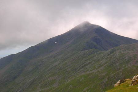
Ben Cruachan (1126 metres) has the irresistable attraction for the serious hillwalker of providing a readily accessible, but long and challenging ridge with several prominent summits, including the two Munros Ben Cruachan and Meall Cuanail. It is in a superb scenic location overlooking Oban and the Argyll coast and should be on every walkers "must-do" list.
Ben Cruachan also provides the spectacular location for the world's first underground reversible pumped storage hydro scheme. Cruachan power station was constructed between 1959 and 1965. It generates up to 440 megawatts of electricity and is housed in a huge man-made cave built into the mountain. Water is pumped from nearby Loch Awe, 360 m uphill to Cruachan Reservoir and then released as needed during peak periods. The Power Station is a five star visitor attraction, and its visitor centre welcomes over sixty thousand visitors each year. So well is it constructed, that very little is evident from the surface.
Our party of six ascended in fine spirits one June day from the Falls of Cruachan railway station - a request stop on the Oban line. Going through the tunnel, follow the path beside for Hydro power station. We immediately lost the path in the thick new growth of fern and rather foolishly struggled on through wild woodland and high bracken until we regained the way much higher up in the heather. The secret of success is not to continue up the concrete steps that go around to the left of the power station and then just bluff it out through the dense woodland, but to break left on a fairly inconspicuous path at the corner about half way around. So we were a rather sweaty and tired party as we slogged up to the dam and reservoir.
Ben Cruachan is a long rocky ridge running mainly Eat-West. The two Munros, Ben Cruachan and Stob Diamh form the main part of the ridge, with several subsidiary prominences on both sides. The most popular ascent involves a circuit of Coire Cruachan, and this can be taken either way around.
We chose the anti-clockwise route via Meall Cuanail and half way up the exposed slope we were hit by a sudden and very cold squally hail shower. Temperatures plummeted and soon we were wrapped up in full winter gear, fleeces, waterproofs, mittens, the lot! Another reminder, if one were needed, that Scottish hills, even in Summer, are never to be underestimated or attempted without due assessment of the weather and conditions.
The ridge climb itself is mostly straightforward scrambling up and down, with one vertical "bad step" descent of perhaps 4 metres down a narrow crack fairly close to the main summit, very exposed to the steep slabs below. This obstacle would probably put off parties with no climbing expertise, and could be quite tricky in snow or poor weather. A rope might be advisable to aid the inexperienced.
Our party completed the traverse in the guidebook time of seven hours, and we incorporated all the minor summits including the Corbett of Beinn a Bhuiridh. The weather threw all four seasons at us, and by the time we finally reached the road again, I felt it was one of the most rewarding days out to be experienced anywhere in Britain.
Other walks nearby
| Walk 3699 | The Black Lochs from Connel | easy/mod | 6.0 miles |
| Walk 3273 | Ben Starav | hard | 8.0 miles |
| Walk 1879 | Ben Starav & Glas Bheinn Mhor` | hard | 10.0 miles |
| Walk 1865 | Loch Dochard (near Bridge of Orchy) | easy/mod | 8.5 miles |
| Walk 2491 | Old Military Road from Victoria Bridge | easy/mod | 6.5 miles |
| Walk 1495 | WHW - Day 5 - Inveroran to Kinlochleven | moderate | 19.0 miles |
| Walk 1494 | WHW - Day 4 - Inverarnan to Inveroran | moderate | 21.0 miles |
| Walk 1019 | Beinn an Dothaidh & Beinn Dorain | moderate | 8.5 miles |
| Walk 3277 | Beinn Dorain | mod/hard | 6.2 miles |
| Walk 2317 | Ben Vorlich from Ardlui | mod/hard | 6.8 miles |
Recommended Books & eBooks
No suggestions for this area.Messaging & Social Media
Message Walking Britain and follow the latest news.

Mountain Weather
Stay safe on the mountains with detailed weather forecasts - for iOS devices or for Android devices.