Southease or Rodmell to Falmer
South Downs Walk
Nat Park - South Downs
County/Area - East Sussex
Author - Barry Mackie
Length - 6.8 miles / 11 km Ascent - 1010 feet / 306 metres
Time - 4 hours 20 minutes Grade - easy/mod
Maps 

| Ordnance Survey Explorer OL11 | Sheet Map | 1:25k | BUY |
| Anquet OS Explorer OL11 | Digital Map | 1:25k | BUY |
| Ordnance Survey Landranger 198 | Sheet Map | 1:50k | BUY |
| Anquet OS Landranger 198 | Digital Map | 1:50k | BUY |
Walk Route Description
Click image to visit gallery of 11 images.
There are two possible starting points for this section of the South Downs Way that lies within the South Downs National Park. If you travel by train, then as you leave the railway station near Southease you are already on the SDW and the nice scenic route ahead of you bypasses the village of Rodmell. However you might want to start at Rodmell if you need to park a car. If you are travelling by bus, both locations can be reached (see transport details). On the walk itself, the route is very well signed. All you need to do is look out for the distinctive acorn symbol. As this walk is on a bridleway and direction arrows are therefore coloured blue.
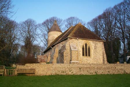
Starting from Southease - Leave the railway station and turn left on the narrow road to cross the River Ouse which is still tidal here, although the sea is still some four miles away to the south at Newhaven. Towards the end of the narrow lane you will reach the 13th Century Church at the tiny hamlet of Southease. With its round tower, this church is almost unique, being one of only three of its type in the county. The other two are also being situated within the Ouse Valley. Continue past the right side of the church to the T Junction, turning right, then left to the road signposted to Telscombe Village and St Lawrwence Church. To the right of this junction is a five barred gate and a finger post directing the way through the fields to Mill Hill (Grid ref TQ412053) and where the path meets the one coming from Rodmell
Starting from Rodmell - Looking south from the front of the Abergervenny Arms (Grid ref TQ418059) turn right into Mill Road. Go up the road and onto the private road (bridleway) to reach the waymarker by the gate to the fields and join the SDW coming from Southease. Take the narrow path to the right of the house (also named Mill Hill) and if you have had a look at the margins of your map, you will see that it is very close to here that you cross the Greenwich Meridian, i.e. it's a mere step over from the Eastern to the Western Hemisphere!
At the end of this short path it is out into the countryside and the way heads in a general northwest direction along the top of the downs through a mixture of arable and grazing farmland and soon alongside some steep slopes and the Weald of Sussex to your right. Depending on the weather conditions, you may get sea views in the direction of Saltdean to the south. Visibility was not quite good enough when we did this walk but it was just about possible to spot Saltdean itself. To the right and somewhat closer, looking over the Weald and using your map as a reference, with a bit of luck you will be able to pick out the towns and villages dotted amongst the incredible views that are to be seen for mile after mile along the walk.
Keeping in the same direction, you are soon on a concrete road, easily gaining height and heading for Front Hill. The way here is between the fields and when we did the walk (late March) they were planted with rape seed and the flowers were almost in full bloom. With the wind rippling the tops, this made for a wonderful sight - a sea of yellow in every direction; absolutely magical!
After reaching Front Hill, the route continues on to Iford Hill and then turns to the right at grid ref TQ391067. Here it leaves the concrete track and follows along the crest of Swanborough Hill, still alongside the edge with the steep slope to the right. Incidentally, whilst there is a fence alongside on most of this section, there is also the occasional gate and signs stating that this area is access land. A short walk over the brow and a little way down the slope opens up even more superb views. It is along this section that you'll see the first of several dew ponds alongside the path and although they all have the same purpose, they are all different and it is very easy to have a wander around and have a good look at them (See footnote).
At grid ref TQ379079 the way veers left in a south westerly direction on the track known as the old Juggs Road and for a while heads in the direction of the prominent radio mast in the distance. The path does not reach as far as the radio mast, but instead turns right at grid ref TQ370074 and still with the steep slope to the right, leads directly to the woodland (Newmarket Plantation). Losing height now, turn right at the edge of the woods and walk down the slope at the edge of the field to reach the smaller woods. Follow the clear path to reach and go under the railway arch.
Now turn left and walk alongside the field, parallel to the A27 to the bridge over the road (grid ref TQ367091). Cross the bridge and turn right onto the side road and here, away from the bustle of the traffic on the main road, is a convenient place to finish this walk. If you are in need of refreshments, then along the main road to Lewes there is a petrol station and a bit further along, on the other side of the road, The Newmarket Inn.
Footnote The dew ponds on the downs are man-made structures that were originally constructed to provide water for the livestock that graze in the region. In spite of their name, dew is not the main source of water as generally, rainfall is equal or more than the combined loss by evaporation and livestock consumption. More information is provided alongside one or more of the dew ponds seen on this walk.
Transport There is a bus stop at the Lewes end of the lane on the A27, which will take you to Lewes and from there a rail link to Southease and buses to Rodmell and Southease. There is a bus stop close to Southease station at Itford Farm on the A26 Newhaven Road. Services alter all the time, so you must check times before you set out. To reach Rodmell or Southease by car, take the A27 to Lewes and then follow signs to Kingston and then continue on the same road.
Other walks nearby
| Walk 2419 | Southease, Ditchling Beacon & Lewes | mod/hard | 17.0 miles |
| Walk 1038 | Firle Beacon | moderate | 13.3 miles |
| Walk 1633 | Charleston Farm & Firle Beacon | easy/mod | 4.6 miles |
| Walk 2684 | Falmer to Pyecombe & Blackcap by South Downs Way | moderate | 8.8 miles |
| Walk 1015 | Ouse Valley & Beddingham Hill | moderate | 12.0 miles |
| Walk 2903 | Stanmer to Streat | moderate | 12.5 miles |
| Walk 3575 | High and Over White Horse | easy | 2.0 miles |
| Walk 3120 | Alfriston to Rodmell by the South Downs Way | moderate | 9.0 miles |
| Walk 3574 | Firle Beacon & Cuckmere Valley | moderate | 10.4 miles |
| Walk 2486 | Plumpton Green & South Downs | easy/mod | 7.7 miles |
Recommended Books & eBooks
Walks in the South Downs National Park
 Guidebook with 40 circular walks throughout the South Downs National Park, exploring the beautiful chalk hills between Eastbourne and Winchester. The walks range from under 5 miles to 11 miles, including Beachy Head and the Seven Sisters, Ditchling Beacon and hundreds of prehistoric sites. Accessible all year, but wild flowers best in spring.
More information
The South Downs Way
 Guidebook to walking the South Downs Way National Trail, a 100 mile (160km) route between Winchester and Eastbourne through the South Downs National Park, described in both directions over 12 stages. Easy walking on ancient and historical tracks, taking in wooded areas, delightful river valleys and pretty villages. With 1:25K OS map booklet.
More information
Messaging & Social Media
Message Walking Britain and follow the latest news.

Mountain Weather
Stay safe on the mountains with detailed weather forecasts - for iOS devices or for Android devices.