Lothersdale from Cowling
South Pennines Walk
Region - South Pennines
County/Area - North Yorkshire - South Pennines
Author - Allan Friswell
Length - 6.0 miles / 9.8 km Ascent - 1100 feet / 333 metres
Time - 4 hours 10 minutes Grade - easy/mod
Maps 

| Ordnance Survey Explorer OL21 | Sheet Map | 1:25k | BUY |
| Anquet OS Explorer OL21 | Digital Map | 1:25k | BUY |
| Ordnance Survey Landranger 103 | Sheet Map | 1:50k | BUY |
| Anquet OS Landranger 103 | Digital Map | 1:50k | BUY |
Walk Route Description
Click image to visit gallery of 3 images.
Park in the vicinity of the village Post Office (Grid ref. SD973431). From here walk up the hill and take the steep lane on your right down to Ickornshaw. Walk through the hamlet and keep on the road along Gill Lane, continuing along the main street of Middleton hamlet, and out into open country. The road climbs. Where it turns left, take the narrow road downhill on the right. At the foot turn right along a track, which is signed. Cross the stile. Bear left uphill to the stile by a gate, close to the power pole. Keep straight ahead making for the farm buildings. At the top of the field turn left, making for the stile and the next.
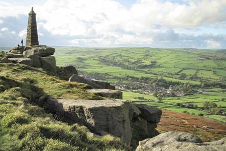
Make for the gate on the left of the farmhouse, and negotiate the stile/gate. The next gate/stile are at the top of the field straight ahead. Take the time to look behind you, with the hamlets of Ickornshaw and Middleton ahead and Cowling to the left dominated by the salt and pepper pots of Wainman's Pinnacle on the right and Lund's Tower further along.
Follow the right-hand wall uphill and cross the stile on to the metalled lane. Here you turn right, then immediately left. Follow the road downhill, round a sharp left-hand bend. Where the road bends right, take the stile on the left. The path bends to the right and then sharply left downhill to a gate. Keep the wall on your left downhill to ?a gate on the other side of a little beck. Follow the right-hand side of this field uphill, heading for Woodhead Farm and the stile/gate.
Keep ahead uphill, passing a couple more houses. Cross a cattle grid. 75 yards after the grid, the Pennine Way forks off on the right and descends steeply and somewhat scarily into Lothersdale, which lies giddily below. You feel you could fly down. You arrive at a gate (Grid ref SD958458). Watch out as you cross - the lower step on the other side is broken. Go down the well-made steps neatly bordered with herbaceous plants. At the road, turn right into the village. Leaving the pub on your left, look for the signposted path to Cowling 25 yards ahead on your right. Follow this down the steps and wind through the cottages to the gate at the foot of the chimney. Follow the beck to the sewage farm.
Here you cross the bridge and a stile (Grid ref SD965454), to follow the well-worn path on the right. Keep following the wall under power lines. After 75 yards you arrive at a gate with the tightest of squeeze stiles beside it. Then there's another one! Go ahead along the lane, and take the path on the right after 25 yards. Go through the gate or squeeze stile, hidden behind the signpost here, followed by a stile-cum-hole in the wall. Follow the left-hand edge of the field uphill to a stile. Go on uphill, keeping straight on as the hedge moves away from you. Before you get to the farm a gap in the fence appears to your left. Cross the little beck and head for the right-hand side of the farmhouse. Right by the garage is the exit stile. Go through the car parking area and follow the track away.
Pass through the gated stile on to the road. Cross the road and head down between the caravans, with the entrance gates to the Baptist church on your right, into the farmyard. Go down through this. There are two gates ahead. Go through the left-hand one, then the gate in the middle of the wall ahead and descend the field, making for the right-hand corner and the road sign where you see a kissing gate followed by a sturdy but steep ladder stile on to the road. Turn right.
The road bends sharp right and 25 yards after this you take the squeeze stile on the left. Walk half left across the field going down a steep incline and keeping the beck near on your right. Go across this stile. You descend ladder steps, and the you must then find a way across the beck before clambering up the other side and turning left, to follow the line of the beck. Note After rain you may find it difficult to cross the beck.
The path keeps disappearing but stay on line. Eventually, after you have ducked under yet more Hawthorn trees you come to a gate where the path veers sharp right. Go through it. Keep following the course of the beck, through another gate and take care not to miss the bridge, hidden away at the bottom of a slight ridge. Follow the path right as it climbs gently away from the beck, and finally running parallel with the power lines. You come to a green T-junction. Turn right. Head down back to the beck, passing a couple of benches and cross the bridge. The path becomes paved, then setted. Go over the bridge. More slabs, then steps lead you to houses, steps and then a broad track which leads to the main road. Turn right and walk back up through the village to the shop.
Other walks nearby
| Walk 2861 | Pinhaw Beacon from Lothersdale | easy | 4.0 miles |
| Walk 2904 | Cross Hills to Skipton via Low Bradley | easy/mod | 6.5 miles |
| Walk 3430 | Farnhill Moor from Kildwick | easy/mod | 4.5 miles |
| Walk 2657 | Bradleys Both, near Skipton | easy/mod | 5.5 miles |
| Walk 3215 | Steeton to Ilkley without a car | moderate | 7.5 miles |
| Walk 3079 | Silsden Reservoir circular | easy | 6.0 miles |
| Walk 1135 | Top Withins and the Bronte Bridge | moderate | 8.0 miles |
| Walk 1585 | Haworth Moor circular | easy | 5.0 miles |
| Walk 1243 | Haworth Moor and Bronte Bridge from Oxenhope | easy | 3.5 miles |
| Walk 2942 | Below Silsden Moor | easy/mod | 6.8 miles |
Recommended Books & eBooks
The Pennine Way
 Guidebook to the Pennine Way National Trail with OS map booklet. The 265 mile route from Edale to Kirk Yetholm takes three weeks to walk and is suitable for fit and experienced long distance walkers. The route crosses the Peak District, Yorkshire Dales and North Pennines National Parks. Includes separate OS 1:25,000 map booklet of the route.
More information
Pennine Way Map Booklet
 Map of the 270 miles (435km) Pennine Way National Trail, between Edale in the Peak District and Kirk Yetholm in the Scottish Borders. This booklet is included with the Cicerone guidebook to the trail, and shows the full route on Ordnance Survey 1:25,000 maps. This popular long-distance route typically takes three weeks to complete.
More information
Messaging & Social Media
Message Walking Britain and follow the latest news.

Mountain Weather
Stay safe on the mountains with detailed weather forecasts - for iOS devices or for Android devices.