Downham & Pendle Hill
Forest of Bowland Walk
Region - Forest of Bowland
County/Area - Lancashire
Author - Stephen Starkey
Length - 8.0 miles / 13 km Ascent - 1680 feet / 509 metres
Time - 5 hours 40 minutes Grade - moderate
Maps 

| Ordnance Survey Explorer OL41 | Sheet Map | 1:25k | BUY |
| Anquet OS Explorer OL41 | Digital Map | 1:25k | BUY |
| Ordnance Survey Landranger 103 | Sheet Map | 1:50k | BUY |
| Anquet OS Landranger 103 | Digital Map | 1:50k | BUY |
Walk Route Description
Click image to visit gallery of 7 images.
A circuit from the pretty village of Downham that takes in Pendle Hill. On a clear day there are extensive views over the Ribble Valley to the Yorkshire Dales and the Southern Lake District, across Burnley to the Southern Pennines and across Clitheroe to the Trough of Bowland.
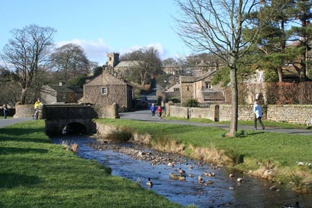
The car park (grid ref SD785440) marked on the OS map is not visibly signposted in the village. Assuming an approach from the Clitheroe / Chatburn side, descend the hill from the church, swing right over the bridge to cross Downham Beck then keep bearing right in to what appears to be a farm yard where the car park, public toilets and information centre are located. The free car park has space for about 25 cars but be aware that this is a popular place on a nice day. There are also options for road side parking beside Downham Beck but this is not ideal in a small village with narrow roads.
Having followed the concessionary paths as seen on the ground and then downloaded the track from a GPS, it is apparent that the paths indicated on the OS Explorer OL41 map do not match those visible on the ground. In some instances they are more than 200m different. Significant parts of the route are very wet underfoot so gaiters are strongly recommended. The descent from Pendle Hill is steep and the short grass can be very slippery when wet - walking poles may be helpful. There are short sections where the path is either indistinct or leads you off in the wrong direction so proficiency with a map and compass is required.
From the car park, return to the road at the side of Downham Beck where you will see two roads heading in an ESE/SE direction. Ignore the "main" road that you drove down and take the narrower of the two that runs alongside the right hand bank of Downham Beck, passing some picturesque cottages, a number of which have their own private bridges across the beck. At the end of the cottages, pass through the gate in to the field and follow the waymarked footpath. This initially tracks alongside the beck before veering away gradually to the right. About 170m after starting to veer away from the beck, the footpath forks. At this point take the right hand path, heading SE and almost parallel to Pendle Road. At the time of writing (Feb 07), Lancashire County Council were in the middle of restoring this section of path and as a result some sections are temporarily difficult to walk.
The way ahead is reasonably obvious as far as the stile over the wall part way up a gentle incline (grid ref SD796434). From the stile, note the small barn ahead and aim for the left hand side of the barn where there is a step stile built in to the wall. On emerging on to Pendle Road, continue ahead across the road on to a concessionary path signed to Pendle Hill. The path in this section is very wet underfoot and although the incline is gentle, it is hard going with the soft ground. Ironically when the gradient steepens, the walking gets easier as the path is generally better and much drier. The path here does not correlate with the OS map and, although it does a zig-zag traverse of the slope, it is not in the exaggerated manner indicated by the map. When the legs request a quick breather, oblige as the views behind over the Ribble Valley are worth pausing for.
As you near a wall, note the clear path off to the right across the moor – this is the return route. On reaching the wall, cross by means of the ladder stile from where it is but a short distance with a very gentle incline and a good path to the trig point at the summit of Pendle Hill. The plateau shaped summit offers good views in most directions but to get the best views it is necessary to walk away from the summit. In particular it is worth continuing South from the summit to where the track doubles back left at grid ref SD804408, a point that offers dramatic views over Barley towards Burnley and also reveals a very different aspect of Pendle Hill.
From the summit, return to the ladder stile and cross it once more then fork left on to the path seen earlier. This is another section that tends to be very wet underfoot though the path is obvious as far as a ladder stile over a wall. The path on the far side of the wall is not so obvious but, conveniently, a large round stone shelter ahead is the point to aim for. From the shelter, a large cairn can be seen ahead and there are two paths that both lead there. The cairn was built by local scouts in the 1980's to mark three events, each of which is recorded on a commemorative plaque set in to the cairn.
From the cairn, follow the path ahead for about 100m to where a very indistinct path cuts off right through the rough moorland grass. If you spot the path, follow it. If you don't find this path, don't panic. If you get as far as a stream you've gone too far but only by about 30m. Come back from the stream then strike off on a compass bearing of degrees. As you crest the rise, you will see three cairns in front of you. Aim for either of the two right hand ones and you will easily locate the required path which is much more distinct at this point.
The path is now clear as it descends quite steeply from Pendle Hill towards the corner of a wall on Worston Moor. On reaching the wall, it initially appears as though the path comes to a dead end. However, if you continue past the fallen tree and fence, you will see a stile hiding in the corner. The path here is narrow, on a steep incline and is slippery mud as a result. After crossing the stile, the path descends to the right of a wall across another section of wet ground. Along this section there are a series of stones set in to the ground with small discs attached to indicate the direction of the concessionary path.
On reaching the end of a minor road where a footpath crosses, continue ahead along the minor road for about 350m to a right hand bend. Ignore the waymarked footpath ahead and follow the road round the bend for about another 110m. You will then see another footpath sign to the left, along a farm access track. Follow the track to where it starts to bend left towards the farm house. At this point keep walking straight ahead, gently uphill, to a metal gate in the wall. Pass through the gate then turn right along a clear path that passes through a number of fields and leads you back to the car park in Downham.
Other walks nearby
| Walk 2632 | The Ribble Valley from Sawley | easy/mod | 9.0 miles |
| Walk 2217 | Clitheroe Town Trail - Ribble Valley | easy | 1.0 miles |
| Walk 1267 | Pendle Hill | moderate | 5.0 miles |
| Walk 1287 | Circuit of Pendle Hill | moderate | 8.5 miles |
| Walk 2720 | Pendle Hill (use in mist) | moderate | 5.0 miles |
| Walk 2938 | Nick of Pendle from Pendleton | easy/mod | 6.3 miles |
| Walk 3111 | Barley Circular | easy/mod | 7.5 miles |
| Walk 2293 | Weets Hill | easy/mod | 5.3 miles |
| Walk 2216 | Slaidburn Village Trail - Ribble Valley | easy | 0.8 miles |
| Walk 3329 | Stocks Reservoir from Slaidburn | moderate | 11.5 miles |
Recommended Books & eBooks
Walking on the West Pennine Moors
 This guidebook describes 30 walks on the West Pennine Moors, around Blackburn, Darwen, Chorley and Bolton, home to some of the most inspiring and exhilarating walking country. The walks range from short, easy rambles to more challenging hikes covering a variety of terrain, all of it easily accessible for day walking.
More information
Walking in the Forest of Bowland and Pendle
 A guidebook to 40 diverse circular day walks suitable for walkers with navigational skills. The Forest of Bowland and Pendle are two of north west England's upland AONBs, perfect for walkers who enjoy exploring rough hilly, sometimes pathless terrain. The routes include Ward's Stone, Pendle Hill, Longridge Fell and Fair Snape Fell.
More information
Messaging & Social Media
Message Walking Britain and follow the latest news.

Mountain Weather
Stay safe on the mountains with detailed weather forecasts - for iOS devices or for Android devices.