Ivinghoe Beacon from the Ashridge Estate
Chilterns Walk
Region - Chilterns
County/Area - Hertfordshire & Buckinghamshire
Author - Lou Johnson
Length - 6.5 miles / 10.6 km Ascent - 1000 feet / 303 metres
Time - 4 hours 20 minutes Grade - easy/mod
Maps 

| Ordnance Survey Explorer 181 | Sheet Map | 1:25k | BUY |
| Anquet OS Explorer 181 | Digital Map | 1:25k | BUY |
| Ordnance Survey Landranger 165 | Sheet Map | 1:50k | BUY |
| Anquet OS Landranger 165 | Digital Map | 1:50k | BUY |
Walk Route Description
Click image to visit gallery of 12 images.
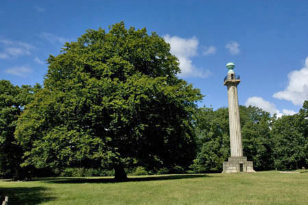
This linear Hertfordshire walk starts from the car park at the Bridgewater Monument (Grid ref SP971131) on the National Trust Ashridge Estate. There is additional parking along the drive if the car park is full. There is also a national Trust Information Centre and café.
Walk to The Monument. This is an 1832 memorial to the 3rd Duke of Bridgewater, a pioneer of canal building, which may be ascended weekend afternoons in season. Turn right along the track marked Mobility Vehicles Trail and the Ashridge Border Path. The way ahead is clear and you cross a footbridge, pass a wooden house on the left and, quite a bit further on, a log seat with a view over Duncombe Farm and the valley and hills beyond. Continue ahead ignoring all cross paths to pass the rear of Clipper Down (grid ref. SP964147), which is easily recognised by the dogs barking as you pass. Just past the cottage you join their access track and continue along this for approximately 200 metres where you bear left to follow the signed path downhill to a path junction with the Ridgeway (grid ref. SP958153).
Turn right here into Incombe Hole and climb on the clear path. This veers northwards and follows the rim of Incombe Hole. The path soon begins to descend and reaches a road at a bend (grid ref. SP960163). This is a nasty spot to cross and some care is needed. Cross the road and follow the undulating path leading to the trig point and topograph on Ivinghoe Beacon. In good weather the view over the Vale of Aylesbury is extensive. The return route follows the outward path.
Other walks nearby
| Walk 3025 | Ashridge Estate Circular | easy | 4.5 miles |
| Walk 1007 | The Ashridge Estate circular | easy/mod | 6.0 miles |
| Walk 2071 | Ivinghoe Beacon and Bridgewater Monument from Tring | easy/mod | 8.0 miles |
| Walk 2496 | Cow Roast and Aldbury from Tring Station | easy | 5.5 miles |
| Walk 3503 | Circular from Berkhamsted | easy | 4.0 miles |
| Walk 1297 | Berkhamsted and Northchurch Commons | easy | 5.0 miles |
| Walk 1399 | Berkhamsted & Northchurch Commons | easy | 5.5 miles |
| Walk 3098 | Tring & Wendover Woods | easy/mod | 7.5 miles |
| Walk 2795 | Circular from Great Gaddesden to Little Gaddessden | easy/mod | 7.5 miles |
| Walk 2999 | Mansions & Parklands from Great Gaddesden | easy/mod | 7.0 miles |
Recommended Books & eBooks
No suggestions for this area.Messaging & Social Media
Message Walking Britain and follow the latest news.

Mountain Weather
Stay safe on the mountains with detailed weather forecasts - for iOS devices or for Android devices.