Gas Street Basin & The Bull Ring, Birmingham
West Midlands Walk
County/Area - West Midlands
Author - Lou Johnson
Length - 2.5 miles / 4.1 km
Ascent - nominal or unknown
Time - 1 hours 20 minutes Grade - easy
Maps 

| Ordnance Survey Explorer 220 | Sheet Map | 1:25k | BUY |
| Anquet OS Explorer 220 | Digital Map | 1:25k | BUY |
| Ordnance Survey Landranger 139 | Sheet Map | 1:50k | BUY |
| Anquet OS Landranger 139 | Digital Map | 1:50k | BUY |
Walk Route Description
Click image to visit gallery of 12 images.
A wander through the city centre exploring both modern and historical aspects. The start is outside the Council House in Victoria Square (Grid ref SP066869). This point can be easily reached on foot from most city centre car parks, the railway stations and bus termini.
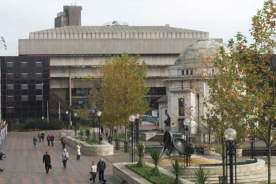
With your back to the Council House facing the 'Floozie in the Jacuzzi' turn right and walk to the end of the building. Turn right again between the Council House and the Town Hall to enter Chamberlain Square with the entrance to the Museum and Arty Gallery on your right. Go half left across this square to the Central Library building entering through the glass doors to the right of MacDonald's.
Continue straight through the building and exit into Centenary Square passing the Hall of Memory to your left, the Repertory Theatre on your right and the "Big Wheel" on your left to reach the glass entrance doors to the Symphony Hall and International Convention Centre complex. Go straight through this building to reach the canal side. Do not cross the bridge instead turn right along the towpath with the canal on your left. Ahead is the National Indoor Arena. Continue past the Malt House pub and cross the canal over the cast iron bridge. Turn left recross the canal to follow the signs past the Sea Life Centre into Brindley Place, which is dominated by the Italianate style of number 3 Brindley Place with its impressive tower.
Exit Brindley Place to the right of number 3 when facing its front. This leads between restaurants to a bridge across the canal. Do not cross the bridge instead go left down to the canal side and turn right under this bridge. Follow the canal south under Broad Street to Gas Street Basin.
Continue ahead to reach a modern footbridge and footway that leads you upwards towards the Mailbox shopping and office complex. At the end of this footway turn left and enter the Mailbox. On your right are the BBC Studios where the 'action' can be viewed through windows. Using steps and escalators continue through the complex to reach street level. Do not walk under the main road instead turn right and follow this busy route as far as Holloway Circus. Using the subways reach the centre of this roundabout with its Chinese Pagoda and attractive mosaic murals.
Exit the circus by following the signs to the Hippodrome Theatre. This will lead you onto Smallbrook Queensway which is followed as far as the first junction where you turn right. Walk past the Hippodrome which is on your right to reach the "Back to Backs" which the National Trust has recently restored.
Return towards the Hippodrome and turn right into Ladywell Walk which is the centre of Chinatown in Birmingham. At the end of this street cross over and turn left with the new Market on your right. At the end of this building turn right and walk towards the Bull Ring with St Martin's Church, the Rotunda and Selfridges being the key landmarks.
Walk past the west door of St Martins and climb steeply up past Nelson's monument to pass between the shopping malls of the Bull Ring centre. As the pavement levels look out on your left for the large bronze bull, a popular meeting point, with the Rotunda rising above. Fork left into New Street and follow this for some way to reach Victoria Square and the start of the walk.
Other walks nearby
| Walk 3068 | Canal from Birmingham to Sandwell | moderate | 8.0 miles |
| Walk 1501 | Lickey Hills, Barnt Green and the Bittell Reservoirs | easy | 4.5 miles |
| Walk 2716 | Walton & Clent Hills from Nimmings Wood | easy | 3.5 miles |
| Walk 2667 | Barston Circular | easy | 4.3 miles |
| Walk 3683 | Hockley Heath and Packwood Circular | easy | 4.1 miles |
| Walk 3711 | Heronfield & Temple Balsall Circular | easy/mod | 7.2 miles |
| Walk 1614 | Meriden & Berkswell Circular | easy/mod | 8.0 miles |
| Walk 1713 | Packwood House Circular | easy | 4.0 miles |
| Walk 3689 | Balsall Common & Berkswell Circular | easy | 5.6 miles |
| Walk 1376 | Balsall Common Circular | easy | 5.0 miles |
Recommended Books & eBooks
No suggestions for this area.Messaging & Social Media
Message Walking Britain and follow the latest news.

Mountain Weather
Stay safe on the mountains with detailed weather forecasts - for iOS devices or for Android devices.