Roaches & Lud's Church
Peak District Walk
Nat Park - Peak District - The Roaches
County/Area - Staffordshire
Author - Lou Johnson
Length - 7.0 miles / 11.4 km Ascent - 1200 feet / 364 metres
Time - 4 hours 40 minutes Grade - easy/mod
Maps 

| Ordnance Survey Explorer OL24 | Sheet Map | 1:25k | BUY |
| Anquet OS Explorer OL24 | Digital Map | 1:25k | BUY |
| Ordnance Survey Landranger 118 | Sheet Map | 1:50k | BUY |
| Anquet OS Landranger 118 | Digital Map | 1:50k | BUY |
Walk Route Description
Click image to visit gallery of 12 images.
This part of Staffordshire offers some superb scenery that is unique to the county. Visitors who are new to area always remark that it does not fit their stereotype of the area and they come away pleased to have made acquaintance with this part of the Staffordshire Moorlands that lies with the Peak District National Park.
The start of this Peak District walk is the lane that runs parallel to the south side of the Roaches. To get here turn off the main A53 Leek to Buxton road at Upper Hulme and follow the lane west to the section where parking is permitted. Note that at busy times of the year parking is soon full so an early or late start is probably the best idea. This walk starts from grid ref. SK006618 where a footpath sign on the north side of the road points to the dip between Hen Cloud and the Roaches. Take this path and climb into the col following a wall on your right. At the top, turn left and go through another wall. Continue straight ahead climbing onto the main ridge that forms the Roaches.
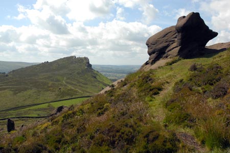
The climb is steady and the view improves rapidly soon covering a large part of North Staffordshire, Tittesworth reservoir, the Cloud and parts of Cheshire. This area is very popular with climbers and has gained a following from those who enjoy bouldering. Passing Doxey Pool, the climb is nearly over and quite soon you reach the trig point marking the summit (505m.). Enjoy the view and then continue along the ridge descending to the road at Roach End (grid ref. SJ995644).
Cross the road and bear right descending on the path signed to Lud's Church. At the first junction (grid ref. SJ994649) take the left hand path and this leads through pleasant woodland to Lud's Church. You can explore this rocky chasm although some of the rock is slippery after rain so care in needed when scrambling. After exploring Lud's Church return to the path and continue in westerly direction to walk in a loop back to the main ridge (grid ref. 977653). Turn left and follow the well trodden path following the ridge back to Roach End. Cross the road and retrace your route over the Roaches and back to the start.
Other walks nearby
| Walk 1178 | Roaches and Lud's Church | moderate | 7.3 miles |
| Walk 1288 | Roaches & Hen Cloud from Tittesworth Reservoir | moderate | 8.5 miles |
| Walk 2577 | Hawk's Nest, Goldstitch Moss & Lud's Church | moderate | 8.0 miles |
| Walk 1596 | Lud's Church and Roach End from Gradbach | easy/mod | 4.5 miles |
| Walk 1598 | Lud's Church, Back Forest & Clough Head | easy/mod | 6.8 miles |
| Walk 3323 | Gradbach, Three Shires Head & Knotbury | easy/mod | 7.1 miles |
| Walk 3197 | Flash, Knotbury & Three Shires Head | easy/mod | 8.2 miles |
| Walk 2519 | The Cloud from Rushton Spencer | easy/mod | 9.0 miles |
| Walk 2604 | Dane Valley & Wincle from Rushton Spencer | moderate | 9.5 miles |
| Walk 2310 | The Cloud from Rushton Spencer (short route) | easy/mod | 5.0 miles |
Recommended Books & eBooks
Great Mountain Days in the Pennines
 An inspirational guidebook to 50 classic walks on the rolling Pennine landscape. The graded routes, between 6 and 13 miles in length, cover classic Pennine fells and moorland such as Whernside, Ilkley Moor and Pendle Hill; exploring the North and South Pennines, Yorkshire Dales, Howgills and Dark Peak. Many routes are also suited to fell running.
More information
Walking in the Peak District - White Peak East
 Guidebook describing 42 half-day and day walks in the limestone landscapes of Derbyshire's White Peak, part of the Peak District National Park. One of two volumes, this book covers the east of the region, with potential bases including Bakewell, Eyam, Castleton, Birchover, Matlock and Wirksworth.
More information
Messaging & Social Media
Message Walking Britain and follow the latest news.

Mountain Weather
Stay safe on the mountains with detailed weather forecasts - for iOS devices or for Android devices.