Whitewell via Crag Stones from Dunsop Bridge
Forest of Bowland Walk
Region - Forest of Bowland
County/Area - Lancashire
Author - Allan Friswell
Length - 8.5 miles / 13.8 km Ascent - 1100 feet / 333 metres
Time - 5 hours 20 minutes Grade - easy/mod
Maps 

| Ordnance Survey Explorer OL41 | Sheet Map | 1:25k | BUY |
| Anquet OS Explorer OL41 | Digital Map | 1:25k | BUY |
| Ordnance Survey Landranger 103 | Sheet Map | 1:50k | BUY |
| Anquet OS Landranger 103 | Digital Map | 1:50k | BUY |
Walk Route Description
Click image to visit gallery of 4 images.
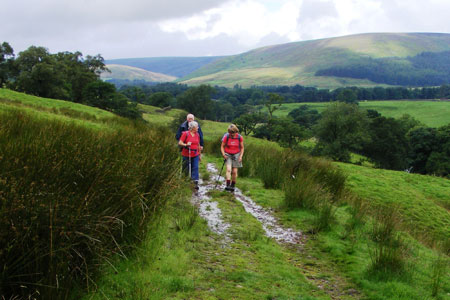
This is a varied walk encompassing conifer woodland, open moorland and meadowland within the Forest of Bowland AONB. The views from Crag Stones and especially at the start of the descent into Whitewell are breath-taking. After wet weather it can be very boggy in many places, so appropriate footwear is advised. Also part of the walk is across unpathed Access Land, so a compass is needed during periods of poor visibility.
The start is the car park in Dunsop Bridge (grid ref. SD661501). Turn left from the car park along the main road, and then cross and turn into the tarmacked track on the south side of the road between the trees. After crossing the bridge go through the little gate at its left hand end and walk along the narrow path parallel with the river on your left. After a couple of hundred yards cross the stile, and follow the path as it drops right, then goes between two trees. Keep ahead making through double gates. Eventually you come to a Concessionary Path on your left. Pass through a couple of kissing gates and follow the very obvious track for a couple of miles, passing Knowlmere Manor on the way. At this point the track divides and you should bear round to the right, eventually coming to a sturdy stone Giddy Bridge over a beck (grid ref. SD682494).
Immediately after the bridge you take the left hand path at a fork. This brings you to a tarmacked road where you turn left and, having crossed Foulscales Brook, turn right at the farmhouse along the public path (grid ref. SD692493). Then follow your nose! After about ½ mile at grid ref. SD696488 take the fenced track which leads off to the right. Go through the gate and cross the beck and keep straight on. At grid ref. SD695483 the path veers sharply left over a low wooden bridge and advances slightly uphill and to the left of the power pole ahead. You reach a gate / stile at grid ref. SD696480. From here make off, heading for the distant marker post at grid ref. SD695478. You should see the landmark of Crag Stones ahead and to your left.
There is no visible path now and the countryside is pretty boggy, so you should carefully negotiate your own route so that the Stones lie uphill on your left, when you turn left and make your way up to them at grid ref. SD696475. From there superb views can be had, including distant Pen-y-Ghent and Ingleborough. From the Crag Stones, drop down westward, keeping the wall close on your left. Again there is no obvious path. Go through the gate at grid ref. SD695472. Drop down and cross a beck, climb to the other side to be confronted by some extremely boggy ground. Keep heading in a south-westerly direction towards the conifer wood to arrive at the exit on to a tarmacked road (grid ref. SD681471), near where the OS map marks a sulphur spa.
Go over the road and take the very clear track through the conifers. Follow this to a lane (grid ref. SD666468). Cross over and follow the path bearing right towards the lower part of the slope ahead, and then follow it steeply downhill via a gate into Whitewell where you reach a main road. Here you turn left and then right. The Inn at Whitewell is now before you. If you can find the entrance just by the end of the inn to the very narrow path (not marked on the OS map) that runs parallel to the road with the Hodder on your left, then take it. Otherwise just follow the road with care until, after about 200 yards you come to a gate on the left, which you go through. In either case you will see a green metal double gate, which you pass through and then follow the hedge with the road immediately on the other side.
Cross the hidden stile in the field corner (grid ref. SD657475). Then cross the road with care and walk to Burholme Bridge. Drop down the near side of the bridge, following the track. A lot of heavy digging is going on at the time of writing (2008), but you will eventually come to Langden Holme Farm, and you pass through it to arrive at yet more excavations. Keep the fencing on your left, go straight ahead across a number of temporary stiles until the last amid a hawthorn hedge, where you turn left and rejoin the "proper" path. Birkett Fell and Hodder Bank Fell accompany you all the way on your right. This will soon bring you to the pipe bridge over the Hodder. (grid ref. SD662493). The path continues on its riverside way until you reach Dunsop Bridge and turn right for the car park.
Other walks nearby
| Walk 2594 | Totridge Fell & Fiendsdale Head, Forest of Bowland | moderate | 11.0 miles |
| Walk 1218 | Fiensdale Head & Bleasdale Water | moderate | 10.0 miles |
| Walk 2384 | Hodder Valley from Whitewell | easy/mod | 6.8 miles |
| Walk 2216 | Slaidburn Village Trail - Ribble Valley | easy | 0.8 miles |
| Walk 3329 | Stocks Reservoir from Slaidburn | moderate | 11.5 miles |
| Walk 2452 | Dunsop Head from Slaidburn | easy/mod | 7.0 miles |
| Walk 3038 | Wolfhole Crag from Tower Lodge | moderate | 9.0 miles |
| Walk 1902 | Saddle Fell, Fair Snape Fell & Parlick from Chipping | moderate | 8.0 miles |
| Walk 2505 | Fair Snape Fell from Fell Foot, Forest of Bowland | moderate | 6.0 miles |
| Walk 3730 | Stocks Reservoir Circular | easy/mod | 7.0 miles |
Recommended Books & eBooks
Walking in the Forest of Bowland and Pendle
 A guidebook to 40 diverse circular day walks suitable for walkers with navigational skills. The Forest of Bowland and Pendle are two of north west England's upland AONBs, perfect for walkers who enjoy exploring rough hilly, sometimes pathless terrain. The routes include Ward's Stone, Pendle Hill, Longridge Fell and Fair Snape Fell.
More information
Walking on the West Pennine Moors
 This guidebook describes 30 walks on the West Pennine Moors, around Blackburn, Darwen, Chorley and Bolton, home to some of the most inspiring and exhilarating walking country. The walks range from short, easy rambles to more challenging hikes covering a variety of terrain, all of it easily accessible for day walking.
More information
Messaging & Social Media
Message Walking Britain and follow the latest news.

Mountain Weather
Stay safe on the mountains with detailed weather forecasts - for iOS devices or for Android devices.