Barden Bridge & the Strid from Bolton Abbey
Riverside Walk
Nat Park - Yorkshire Dales - Lower Wharfedale
County/Area - North Yorkshire
Author - Lou Johnson
Length - 4.0 miles / 6.5 km Ascent - 100 feet / 30 metres
Time - 2 hours 10 minutes Grade - easy
Maps 

| Ordnance Survey Explorer OL2 | Sheet Map | 1:25k | BUY |
| Anquet OS Explorer OL2 | Digital Map | 1:25k | BUY |
| Ordnance Survey Landranger 104 | Sheet Map | 1:50k | BUY |
| Anquet OS Landranger 104 | Digital Map | 1:50k | BUY |
Walk Route Description
Click image to visit gallery of 6 images.
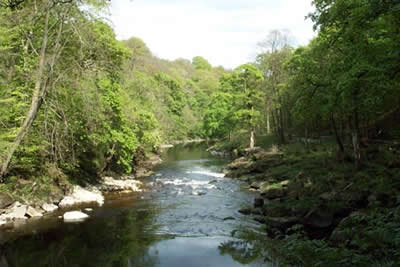
Using a section of the Dales Way alongside the River Wharfe this Yorkshire Dales walk offers a good introduction to the delights of the area around Bolton Abbey. Following the river it is an easy route best completed in late Spring or Autumn. Despite using well-maintained paths, the walk through the grounds of the Estate is recommended. The start, reached by a drive off the B6160, is the car park adjacent to the Cavendish Pavillion (Grid ref. SE 077551). There is a charge and once you have paid you can use other car parks within the Bolton Abbey Estate.
From the car park walk north alongside the River Wharfe to reach a wooden bridge (marked as such on the OS 1:25000 map). Cross the bridge and turn left along the clear footpath along the river bank heading north (upstream). After a short way the path enters deciduous woodland, which forms part of the Bolton Abbey Estate. Well managed, it is a delight to walk through and forms a protected zone for many species of flora and fauna.
About half way to Barden Bridge the Wharfe has to pass through a six foot wide cleft through rock. This is the Strid. Even during periods of low water flow it is an impressive sight and after heavy rain care needs to be taken in case of rapid changes in water level. Continuing through the wood you reach a substantial arched stone bridge and join the Dales Way. The path now crosses broad pastures with views ahead to typical Yorkshire Dales scenery.
Barden Bridge is the next landmark where the path leads up to a public road. Turn left and cross the bridge turning left again to follow the Wharfe downstream. Retracing your steps, but on the other bank, you soon reach the arched bridge and enter the woods. On some sections there is a choice of path with side paths either leading down to the river bank or rising gently into the woods. Passing the Strid you have just over a mile to walk to the Cavendish Pavillion (refreshments and toilets) and the start. If you have a surplus of energy then you can extend the walk south to visit the remains of Bolton Priory. This extension adds just under two miles to the route.
Other walks nearby
| Walk 2574 | Valley of Desolation & Barden Fell | moderate | 11.0 miles |
| Walk 1946 | Valley of Desolation & Simon's Seat | moderate | 8.4 miles |
| Walk 1905 | Beamsley Beacon and Bolton Abbey | moderate | 10.0 miles |
| Walk 2942 | Below Silsden Moor | easy/mod | 6.8 miles |
| Walk 1280 | Trollers Gill | moderate | 9.0 miles |
| Walk 2000 | Wharfedale Circular | moderate | 13.5 miles |
| Walk 1574 | Thruscross Reservoir | easy | 4.5 miles |
| Walk 2319 | Ilkley to Bingley | easy/mod | 7.0 miles |
| Walk 1576 | Embsay Reservoir | easy | 1.0 miles |
| Walk 1573 | Grimwith Reservoir | easy | 4.5 miles |
Recommended Books & eBooks
Walking in the Yorkshire Dales: South and West
 Part of a two-book set, this guidebook describes 44 walks in the southern and western Yorkshire Dales, including the famous 23 mile Three Peaks circuit over Pen-y-Ghent, Whernside and Ingleborough. The other, mostly circular routes of 3½ to 13 miles cover the scenic region between Sedbergh, Kirkby Lonsdale, Settle, Skipton and Grassington.
More information
Walking in the Yorkshire Dales: North and East
 This guidebook contains 43 circular day walks in the north and east Yorkshire Dales. It explores the dales, hills and moors between Kirkby Stephen and Pateley Bridge. Walking ranges from gentle 3 mile strolls to more strenuous day-long rambles across the Howgills, Wensleydale, Swaledale, Nidderdale, Mallerstang and Coverdale.
More information
Messaging & Social Media
Message Walking Britain and follow the latest news.

Mountain Weather
Stay safe on the mountains with detailed weather forecasts - for iOS devices or for Android devices.