Glen Brittle & Coire Lagan
Highland Walk
County/Area - Highland - Isle of Skye
Author - Lou Johnson
Length - 4.6 miles / 7.5 km Ascent - 1880 feet / 570 metres
Time - 4 hours 10 minutes Grade - moderate
Maps 

| Ordnance Survey Explorer 411 | Sheet Map | 1:25k | BUY |
| Anquet OS Explorer 411 | Digital Map | 1:25k | BUY |
| Ordnance Survey Landranger 32 | Sheet Map | 1:50k | BUY |
| Anquet OS Landranger 32 | Digital Map | 1:50k | BUY |
Walk Route Description
Click image to visit gallery of 6 images.
This is a walk of some quality taking you into the rugged heart of the Cuillins. The walk starts at the end of the road down Glen Brittle - a trip worth doing even if you haven't time to walk. The free car park (Grid ref. NG408206) overlooks with the idyllically situated camp alongside. Walk through the campsite to the toilet block. Take the path which heads uphill, ignoring the path heading south along the loch-side. Well maintained, this path climbs steadily and soon splits. Take the left fork and continue climbing.
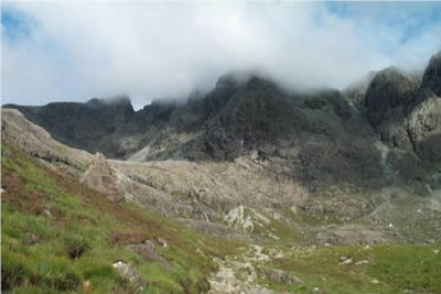
As you gain height your objective becomes obvious - a rocky coire surrounded by tremendous mountains, including the highest peak of the Cuillin - Sgurr Alasdair. To your right the small islands of Soay and Rum can be seen whilst behind the hills on the other side of Glen Brittle look rather docile when compared with those ahead.
After passing close to the southern shores of Loch an Fhir-bhallaich you need to keep straight ahead ignoring the path veering off to the right and the rocky buttresses of Sgurr na Ciche. The going underfoot becomes rockier and the climb steeper as you reach the lip of Coire Lagan. Alongside Allt Coire Lagan tumbles seaward, it ferocity depending on recent rain. Reaching a steeper rocky section some mild scrambling is needed and it is worth making a mental note of your route to make you descent easier.
With each step the crags and screes of the Cuillin move nearer with your eyes working hard to absorb the colours, shapes and feel of the mountains. Suddenly you emerge into the Coire with its beautiful lochan. Defended by high crags the setting is grand and worth the effort expended during the climb. Hopefully the weather will be kind and you can relax in this natural amphitheatre. Of particular note is the Great Stone Shoot, which provides one of the "walkers" routes to the summit of Sgurr Alasdair. Sadly hidden from view, but not too far distant is the Inaccessible Pinnacle, which is the hardest Munro to conquer.
The are two options for the return. Either retrace your steps or more interestingly use the path that skirts the north-eastern shore of Loch an Fhir-bhallaich. This takes you to the waterfall on Allt Coire na Banachdich and allows you to explore the pretty "gorge" as the stream to the valley floor. Reaching the road it is easy to reach the car park by following the road.
Other walks nearby
| Walk 2197 | The Inaccessible Pinnacle and Sgurr Mhic Choinnich | very hard | 6.0 miles |
| Walk 3216 | Sgurr a'Ghreadaidh and Sgurr na Banachdich | very hard | 5.5 miles |
| Walk 2589 | Marsco | moderate | 8.7 miles |
| Walk 1166 | Loch Coruisk | easy | 4.0 miles |
| Walk 3753 | Blabheinn via south ridge | mod/hard | 8.0 miles |
| Walk 3760 | Glamaig (Sgurr Mhairi & An Coileach) | mod/hard | 4.5 miles |
| Walk 2002 | Dun Caan, Isle of Raasay | moderate | 10.6 miles |
| Walk 1164 | The Storr Sanctuary | easy/mod | 3.2 miles |
| Walk 2640 | The Storr & Old Man of Storr | moderate | 5.5 miles |
| Walk 1886 | Carn a' Bhealaich Mhoir | easy/mod | 8.0 miles |
Recommended Books & eBooks
Skye's Cuillin Ridge Traverse
 This 2-volume set provides all the information required to complete the main ridge traverse on Skye's Black Cuillin. Strategy, gear, training, navigation and logistics are covered, and 10 classic scrambles are described. A lightweight second guidebook gives the scrambler detailed maps, topos and route description for the ridge traverse itself.
More information
Walking the Munros Vol 2 - Northern Highlands and the Cairngorms
 Guidebook to walking the northern Munros, covering the northern Highlands, the Cairngorms and the Isle of Skye. 70 routes are described, including those up Ben Macdui, Braeriach and Cairn Gorm. Routes range from 7 to 46km, requiring a fair level of fitness. The second of two guidebooks to walking Scotland's Munros: peaks higher than 3000ft.
More information
Messaging & Social Media
Message Walking Britain and follow the latest news.

Mountain Weather
Stay safe on the mountains with detailed weather forecasts - for iOS devices or for Android devices.