Pendle Hill from Barley Green
Forest of Bowland Walk
Region - Forest of Bowland
County/Area - Lancashire
Author - Lou Johnson
Length - 5.0 miles / 8.1 km Ascent - 1090 feet / 330 metres
Time - 3 hours 40 minutes Grade - moderate
Maps 

| Ordnance Survey Explorer OL41 | Sheet Map | 1:25k | BUY |
| Anquet OS Explorer OL41 | Digital Map | 1:25k | BUY |
| Ordnance Survey Landranger 103 | Sheet Map | 1:50k | BUY |
| Anquet OS Landranger 103 | Digital Map | 1:50k | BUY |
Walk Route Description
Click image to visit gallery of 6 images.
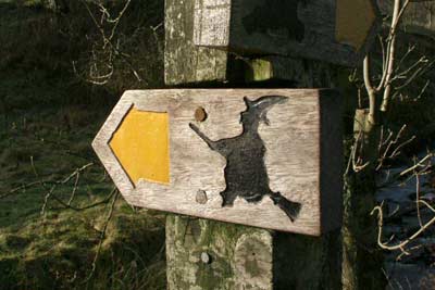
Pendle Hill is famous for its connection with the "Witches of Pendle" and the outward section of this walk follows the Pendle Way, which is identified by a witch on her broomstick! The walk is graded medium because in poor weather navigation on Pendle Hill can be confusing and inexperienced walkers should give this route a 'miss' if cloud is likely to drop onto the hill. A longer version of this walk is detailed in walk 1287.
The start is the car park at Barley Green (Grid ref. SD823403) where there is an information centre, cafe and toilets. From the car park take the lane heading north into the village of Barley turning left onto the signed "Pendle Way" (Grid ref. 821405) after approximately 300 metres. The well marked path climbs steadily to Ing Ends and onto Brown House. Ahead can be seen the steep slope that leads to the summit plateau of Pendle Hill.
After Brown House the path crosses fields to reach Pendle House after which the path steepens to climb diagonally across the slope. The path is paved in sections and despite the angle you will soon have completed most of the ascent and reached a wall. Do not cross the wall but turn round and head across the relatively flat summit area to the trig point located about 400 metres to the south.
On a fine day there are excellent views across Lancashire and into the Yorkshire Dales. Leave the summit on the clear path south that follows the edge, which is on your left hand side. You will reach the point where a path descends left. Ignore this to continue across the moor losing height as you descend to a stile (Grid ref. 807401) above Buttock. Cross the stile and descend east crossing a grassy area to reach a track. Turn right down the track and descend to the base of the dam wall of Upper Ogden Reservoir.
You have the option of climbing up to the dam to enjoy the view of this beautifully located expanse of water with wild moorland on all sides. Return to the base of the dam wall and take the clear track east to pass alongside Lower Ogden Reservoir. This lane leads without any problems to bring you back to the start.
Other walks nearby
| Walk 3111 | Barley Circular | easy/mod | 7.5 miles |
| Walk 1818 | Downham & Pendle Hill | moderate | 8.0 miles |
| Walk 1655 | Downham & Pendle Hill (short version) | moderate | 6.3 miles |
| Walk 2938 | Nick of Pendle from Pendleton | easy/mod | 6.3 miles |
| Walk 2632 | The Ribble Valley from Sawley | easy/mod | 9.0 miles |
| Walk 2293 | Weets Hill | easy/mod | 5.3 miles |
| Walk 2217 | Clitheroe Town Trail - Ribble Valley | easy | 1.0 miles |
| Walk 2196 | Clowbridge Reservoir & Singing Ringing Tree | easy/mod | 4.0 miles |
| Walk 2304 | East Marton and the Drumlins | easy/mod | 5.5 miles |
| Walk 2861 | Pinhaw Beacon from Lothersdale | easy | 4.0 miles |
Recommended Books & eBooks
Walking on the West Pennine Moors
 This guidebook describes 30 walks on the West Pennine Moors, around Blackburn, Darwen, Chorley and Bolton, home to some of the most inspiring and exhilarating walking country. The walks range from short, easy rambles to more challenging hikes covering a variety of terrain, all of it easily accessible for day walking.
More information
Walking in the Forest of Bowland and Pendle
 A guidebook to 40 diverse circular day walks suitable for walkers with navigational skills. The Forest of Bowland and Pendle are two of north west England's upland AONBs, perfect for walkers who enjoy exploring rough hilly, sometimes pathless terrain. The routes include Ward's Stone, Pendle Hill, Longridge Fell and Fair Snape Fell.
More information
Messaging & Social Media
Message Walking Britain and follow the latest news.

Mountain Weather
Stay safe on the mountains with detailed weather forecasts - for iOS devices or for Android devices.