Buckbarrow, Seatallan & Middle Fell from Loweswater
Lake District Walk
Nat Park - Lake District - Lake District Western Fells
Wainwrights - Buckbarrow, Middle Fell, Seatallan
County/Area - Cumbria
Author - Lou Johnson
Length - 7.0 miles / 11.4 km Ascent - 2500 feet / 758 metres
Time - 6 hours 0 minutes Grade - moderate
Maps 

| Ordnance Survey Explorer OL6 | Sheet Map | 1:25k | BUY |
| Anquet OS Explorer OL6 | Digital Map | 1:25k | BUY |
| Ordnance Survey Landranger 90 | Sheet Map | 1:50k | BUY |
| Anquet OS Landranger 90 | Digital Map | 1:50k | BUY |
Walk Route Description
Click image to visit gallery of 12 images.
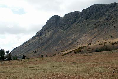
Driving into Wasdale is a special experience with high fells, including England's highest mountain, providing a dramatic backdrop to England's deepest lake, Wast Water. This Lake District circular walk connects three 'Wainwrights' to form a varied horseshoe route, which, although not heading for major peaks, offers some superb mountain panoramas for much of the way.
The start is a small area of grassy verge just east of Greendale (Grid ref. NY144055) at the foot of the path from Greendale Tarn. After parking, walk along the road west towards Gosforth with the first objective, Buckbarrow, rising in steep crags on your right hand side. Stay on the road as far as Gill Beck (Grid ref. NY 129054) where you turn right (north) to follow a clear path that climbs alongside the beck. Stay with this path following it as it turns east away from the beck to climb easily towards Buckbarrow. From here there are excellent views the length of Wasdale, although you do need to explore a little to find the best viewpoint.
Continue north through craggy knolls to the cairn on Glade How (Grid ref. NY 134064) to locate the onward path that descends a little before climbing steadily to Cat Bields. From here you are rewarded with a grand panorama out towards the Irish Sea although it is somewhat spoiled by the Atomic Power facilities at Seascale.
The summit of Seatallan lies just over a mile away in an approximate northeasterly direction. This section is the most tedious of the route although an easy grade means you can make steady progress uphill. Once you have reached the trig point on Seatallan the view suddenly improves with a spectacular panorama in all directions. Included in the view are some of the lesser known fells such as Haycock and Caw Fell.
The easiest descent from Seatallan follows the path to Haycock. Leave Seatallan's summit on a northeasterly bearing and descend steeply over grass towards the col named Pots of Ashness. Do not descend all the way to the col instead turning right as soon as easier ground is reached (Grid ref. NY 143088) from where you contour across the eastern slopes of Seatallan on sheep trods and over rough grass. Ahead you will see Middle Fell, the next objective, with a clear path to aim for.
Climbing once more you soon reach the summit of Middle Fell with its excellent view of Mellbreak, the Scafells and Great Gable. The path continues south along Middle Fell's ridge before turning southwest to descend into Greendale. Joining the path from Greendale Tarn continue downhill to where you started.
Other walks nearby
| Walk 3485 | High Birkhow & Low Wood from Wast Water | easy | 4.2 miles |
| Walk 1176 | Yewbarrow | moderate | 4.5 miles |
| Walk 2341 | Circuit of Nether Beck and Over Beck from Wasdale | hard | 11.3 miles |
| Walk 1690 | Netherbeck Horseshoe - Middle Fell, Steeple & Red Pike from Wasdale Head | mod/hard | 12.5 miles |
| Walk 1126 | Mosedale Horseshoe | hard | 11.5 miles |
| Walk 1246 | Black Sail Pass & Beck Head | moderate | 5.5 miles |
| Walk 2034 | Scafell from Wasdale Head | hard | 6.5 miles |
| Walk 2800 | The Scafells via Piers Gill from Wasdale Head | mod/hard | 7.5 miles |
| Walk 2900 | Pillar (by the High Level Path) from Wasdale | mod/hard | 8.0 miles |
| Walk 2718 | The Scafells from Wasdale Head | mod/hard | 9.0 miles |
Recommended Books & eBooks
Lake District: Low Level and Lake Walks
 This guidebook describes 30 of the best low-level walks in the Lake District. From delightful wooded glades and sparkling tarns, to waterfalls and glacier-carved valleys towered over by craggy mountains. The walks described aim to seek out the best walking that the lower areas of the Lake District have to offer.
More information
Hadrian's Wall Path
 Hadrians Wall Path guidebook to walk the 84 mile National Trail. Described in both directions, the main description is west to east between Bowness-on-Solway and Wallsend, Newcastle, with extensions to Maryport and South Shields. With extensive historical information related to this World Heritage site and separate 1:25,000 OS map booklet included.
More information
Messaging & Social Media
Message Walking Britain and follow the latest news.

Mountain Weather
Stay safe on the mountains with detailed weather forecasts - for iOS devices or for Android devices.