Ben Ledi from near Falls of Leny
Loch Lomond and Trossachs Walk
Nat Park - Loch Lomond and Trossachs
County/Area - Stirling
Author - Lou Johnson
Length - 5.5 miles / 8.9 km Ascent - 2400 feet / 727 metres
Time - 5 hours 10 minutes Grade - moderate
Maps 

| Ordnance Survey Explorer OL46 | Sheet Map | 1:25k | BUY |
| Anquet OS Explorer OL46 | Digital Map | 1:25k | BUY |
| Ordnance Survey Landranger 57 | Sheet Map | 1:50k | BUY |
| Anquet OS Landranger 57 | Digital Map | 1:50k | BUY |
Walk Route Description
Click image to visit gallery of 6 images.
This is a popular walk (even in bad weather!) that offers a well graded route to an excellent summit that offers fine views over the hills of the Loch Lomond and Trossachs National Park.
The start (Grid ref. NN586091) is a small parking area just off the A84 that is reached by a girder bridge across the river just upstream from the Falls of Leny. At busy times parking may be at a premium so an early start is recommended.
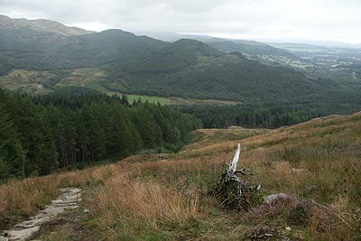
From the car park a clearly marked footpath ascends quite steeply through trees. Underfoot the path is well maintained and height is gained quickly to reach a forest road. Go across this and continue upward on the paved path. You are now clear of the trees and to your right is an excellent view along the length of Loch Lubnaig. Crossing a small stream in a natural rockery garden the path turns south to cross a fence.
The path becomes unpaved and you soon reach a flat area where the path turns north (Grid ref. NN 571 086). The view from here looking southwards is excellent with many small lochs scattered in the valleys. Returning to the task, you ascend once more with some false summits ahead. The going is never steep and subject to cloud cover the views are good. A final descent and ascent leads you to the true summit with its trig point and a memorial.
The return route used was simply to follow the outward route. However you can continue north to the next col and descend into Stank Glen where paths lead back to the valley floor.
Other walks nearby
| Walk 3647 | Callander, Samson's Stone & Coilhallan Wood | easy | 4.7 miles |
| Walk 2309 | Ben A'an from Loch Achray | easy/mod | 2.5 miles |
| Walk 2413 | Ben Venue from Loch Achray | moderate | 8.2 miles |
| Walk 2185 | Ben Vorlich from Loch Earn | moderate | 6.0 miles |
| Walk 2418 | Inverlochlarig, Beinn a'Chroin & Beinn Chabhair | hard | 12.5 miles |
| Walk 1492 | WHW - Day 2 - Dryden to Rowardennan | moderate | 15.0 miles |
| Walk 1493 | WHW - Day 3 - Rowardennan to Inverarnan | moderate | 14.0 miles |
| Walk 1406 | Ben More and Stob Binnein | mod/hard | 6.0 miles |
| Walk 2659 | Conic Hill | easy/mod | 4.0 miles |
| Walk 3009 | Ben Lomond | mod/hard | 7.5 miles |
Recommended Books & eBooks
Walking Loch Lomond and the Trossachs
 A guide to walking and scrambling routes in the beautiful Loch Lomond and the Trossachs National Park. Over 70 graded low-level, mid-level and mountain walks taking in hills, glens and picturesque woodland, as well as all of the region's Munro summits. Highlights include Ben Lui, Ben Lomond, the Cobbler and the Arrochar Alps.
More information
Messaging & Social Media
Message Walking Britain and follow the latest news.

Mountain Weather
Stay safe on the mountains with detailed weather forecasts - for iOS devices or for Android devices.