Dudmaston Estate circular
Shropshire Walk
County/Area - Shropshire
Author - Peter Lane
Length - 4.0 miles / 6.5 km Ascent - 450 feet / 136 metres
Time - 2 hours 30 minutes Grade - easy
Maps 

| Ordnance Survey Explorer 218 | Sheet Map | 1:25k | BUY |
| Anquet OS Explorer 218 | Digital Map | 1:25k | BUY |
| Ordnance Survey Landranger 138 | Sheet Map | 1:50k | BUY |
| Anquet OS Landranger 138 | Digital Map | 1:50k | BUY |
Walk Route Description
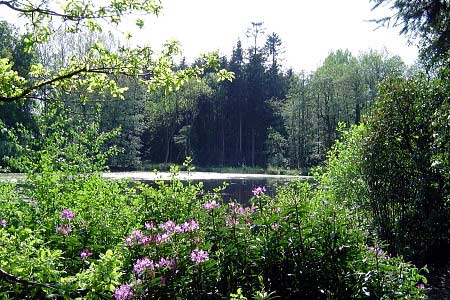
Click image to visit gallery of 4 images.
This walk takes advantage of both public rights of way and National Trust permissive paths that surround Dudmaston Hall. These enable the walker to enjoy delightful views of the Hall from across the ornamental lake, see some of the more neglected areas of the estate and stroll along the River Severn.
Park near the saw mill at the side of the road (Grid ref. SO755889), or alternatively park in the Dudmaston Hall car park if you intend to visit the Hall. Cross a stile opposite the saw mill into a field and turn almost immediately left and follow the path down the field, keeping the hedge to the right, until reaching Wall Pool. A narrow strip of land bridges Wall Pool and Seggy Pool. Cross over and turn left along Seggy Pool and reach Brim Pool. At the end of Brim Pool turn left (not shown as a right of way on OS map, but clear enough on the ground) and reach the A442.
Cross carefully and negotiate a stile opposite leading shortly into the less neglected part of the estate. Permissive paths (not shown on OS maps) lead along the banks of Dudmaston Big Pool affording magnificent views of the Hall and boat house. Follow the banks of the Big Pool as far as possible, then ascend the small rise up to Rookery Cottage. A stile here leads to a footpath flanking the woods to the left and reaching the River Severn.
Follow the Severn until just before the Waterworks bridge and look for a stile on the left leading into thick woods. Negotiate the stile and climb a short distance until reaching the clear Long Covert on the left. This is a pleasant sheltered route in hot or wet weather. The covert eventually emerges into a more open area. Turn right here and when the path forks after a few hundred yards, descend to the left into the Dingle. This is a most delightful spot and replete with Bluebells in season. Negotiate the ford at the bottom and ascend out of the Dingle, eventually reaching the car park and main access to the Hall.
Walk along the access route, past the gate house and cross the main road again (carefully). A stile opposite leads into a field running parallel with the road if you wish to avoid the tarmac, returning swiftly to the saw mill.
Other walks nearby
| Walk 2807 | The River Severn from Hampton Loade to Bridgnorth | easy/mod | 6.0 miles |
| Walk 2092 | Highley from the Severn Valley Country Park | easy/mod | 4.5 miles |
| Walk 3504 | Highley to Bewdley along the River Severn | easy/mod | 7.0 miles |
| Walk 2874 | Enville Estate and the Sheepwalks | easy | 4.0 miles |
| Walk 1934 | Highgate Common and Surrounding Country | easy | 6.0 miles |
| Walk 1933 | Wyre Forest & River Severn from Upper Arley | easy/mod | 7.6 miles |
| Walk 3003 | Kinver Edge & Blakeshall from Holy Austin Rock | easy | 4.3 miles |
| Walk 2834 | Kinver Edge circular | easy | 4.2 miles |
| Walk 3241 | Kinver Edge & Holy Austin Rock | easy | 2.6 miles |
| Walk 2466 | The Severn Valley from Trimpley Reservoir | easy | 6.0 miles |
Recommended Books & eBooks
Hillwalking in Shropshire
 Guidebook to 32 walking routes in Shropshire in the West Midlands. The routes range from 3 miles (5km) to 12 miles (19km), taking in highlights such as The Wrekin, Wenlock Edge, Long Mynd and Stiperstones, Castle Ring and Bury Ditches. Many routes start near delightful towns and villages including Church Stretton, Ludlow and Bishops Castle.
More information
Messaging & Social Media
Message Walking Britain and follow the latest news.

Mountain Weather
Stay safe on the mountains with detailed weather forecasts - for iOS devices or for Android devices.