Mount Segg & Harvington Hall
Worcestershire Walk
County/Area - Worcestershire
Author - Peter Lane
Length - 5.8 miles / 9.3 km Ascent - 430 feet / 130 metres
Time - 3 hours 20 minutes Grade - easy
Maps 

| Ordnance Survey Explorer 219 | Sheet Map | 1:25k | BUY |
| Anquet OS Explorer 219 | Digital Map | 1:25k | BUY |
| Ordnance Survey Landranger 139 | Sheet Map | 1:50k | BUY |
| Anquet OS Landranger 139 | Digital Map | 1:50k | BUY |
Walk Route Description
Click image to visit gallery of 7 images.
This walk starts at Harvington Hall, one of the area's many historic houses. It also visits some of Worcestershire's rolling, agricultural countryside and Mount Segg, a private nature reserve. A public footpath flanks this wooded hill.
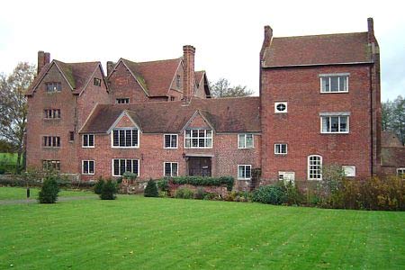
The starting point is the free private car park at Harvington Hall grid reference SO878745. There is ample parking on busy days in the overflow car park shared by St. Mary's Church and the Hall itself. The Hall is famous for its "priest holes" where Roman Catholic priests were hidden from the Protestants at a time when it was high treason to be a Catholic. The Hall is in the classic Elizabethan style built of red brick in the 1580s. It is open to the public and worth a visit - More Info
From the Hall, walk along the lane back towards the hamlet of Harvington picking up a footpath on a sharp bend in the road heading NNE that soon becomes the Monarch's Way. Walk along this well marked route as it follows the hedge-line on the left for about 1km. It then crosses through the hedge, runs diagonally across a field and over a stile opposite into a narrow track that opens into a field running past "Monks" house. Continue to Woodrow Lane where you turn left along the lane, still following the Monarch's Way.
Cross the busy A450 and continue along the lane opposite until a fingerpost to the right indicates the continuation of the Monarch's Way across a field. Despite running through the middle of the field, this path is well trodden and way-marked. Upon reaching Bellington Farm turn right through a gate and follow the way-marks to the bottom of a field, a stile and a stream just beyond. Leaving the Monarch's Way here, turn left and follow the public footpath that runs along the left flank of the woods. Emerge onto Deansford Lane, turn right and walk up to Deansford Farm. Locate the bridlepath opposite the farm and follow the clear path on the ground (the direction differs slightly from the OS map) into the woodland.
Entering the woods over a bridge, turn almost immediately right and flank Mount Segg nature reserve for its entire 1km length. The footpath emerges onto a metalled lane and eventually brings you onto the A448 Bromsgrove Road. Turn left and walk past St Mary's Church (Stone). Just past Butts Lane on the right is a public footpath on the left. Take this path past the cottage garden (take a look over the wall!) and skirt the hedge-line, eventually passing through a metal gate into an open field with a tiny stream running through a disproportionately large valley.
Cross the diminutive stream via the almost superfluous footbridge and climbing the other side of the valley, follow way-marks to the A450 Worcester Road. Cross this and turn right. Cross the lane that turns into Harvington and past a couple of houses turn left along a well marked public footpath. This passes a pleasant pond and then emerges at the moat of Harvington Hall, affording a delightful rear and side aspect to the property.
Other walks nearby
| Walk 2700 | Yieldingtree from Churchill | easy | 5.5 miles |
| Walk 3217 | Bewdley and Snuffmill Dingle | easy | 5.0 miles |
| Walk 2716 | Walton & Clent Hills from Nimmings Wood | easy | 3.5 miles |
| Walk 1603 | Shatterford Wood and Castle Hill circular | easy/mod | 5.5 miles |
| Walk 1806 | Kinver Stroll | easy | 2.0 miles |
| Walk 2024 | Kinver Edge, South Staffordshire | easy/mod | 6.0 miles |
| Walk 3003 | Kinver Edge & Blakeshall from Holy Austin Rock | easy | 4.3 miles |
| Walk 2834 | Kinver Edge circular | easy | 4.2 miles |
| Walk 3241 | Kinver Edge & Holy Austin Rock | easy | 2.6 miles |
| Walk 2131 | Wyre Forest National Nature Reserve, Bewdley | easy | 3.3 miles |
Recommended Books & eBooks
No suggestions for this area.Messaging & Social Media
Message Walking Britain and follow the latest news.

Mountain Weather
Stay safe on the mountains with detailed weather forecasts - for iOS devices or for Android devices.