Pen-y-ghent via Horton Scar from Horton-in-Ribblesdale
Yorkshire Dales Walk
Nat Park - Yorkshire Dales - Three Peaks Country
County/Area - North Yorkshire
Author - Lou Johnson
Length - 6.8 miles / 11 km Ascent - 1530 feet / 464 metres
Time - 4 hours 50 minutes Grade - moderate
Maps 

| Ordnance Survey Explorer OL2 | Sheet Map | 1:25k | BUY |
| Anquet OS Explorer OL2 | Digital Map | 1:25k | BUY |
| Ordnance Survey Landranger 98 | Sheet Map | 1:50k | BUY |
| Anquet OS Landranger 98 | Digital Map | 1:50k | BUY |
Walk Route Description
Click image to visit gallery of 9 images.
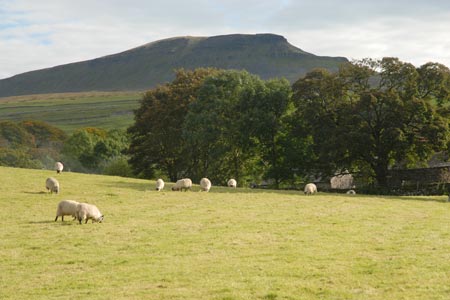
Rising to 694 metres above sea level, Pen-y-ghent is the lowest mountain of the Yorkshire "Big Three". When viewed from the south west its offers a distinctive shape, caused by its geology, and looks a little like the prow of some great ship. Rising above the village of Horton-in-Ribblesdale, the summit is crossed by the Pennine Way and offers some fine views across North Yorkshire and Lancashire. The village of Horton has refreshments (café and pubs) and there are toilets at the main car park. This route to the summit is probably the most popular and can be busy at weekends in fine weather.
The best place to start this Yorkjshire Dales walk is the pay and display car park (grid ref. SD807726) on the northern outskirts of the village adjacent to the River Ribble. Exit the car park and walk south into the village. After a few hundred yards, take the signed walled lane on your left to Pen-y-ghent. The going is fairly easy and you don't really notice the steady climb through some pretty limestone scenery. With Pen-y-ghent clearly in view to your right you cross Horton Scar to reach the end of the walled lane (Grid ref. SD823743).
Go through the gate and turn right on the clear path. The climb continues to be steady as the flank of Pen-y-ghent gets closer. The path turns sharp right with the 2000 feet contour already passed. All that remains is just over 200 feet of ascent to the summit from where there are some wonderful views. To the northwest and west lie the other two mountains of the "Big Three" - Whernside and Ingleborough. To the south lie the hills and moors of Lancashire with Pendle Hill the easiest summit to identify.
Having enjoyed the view, descend by the way you came. Reaching the end of the walled lane, you can make a short diversion to see Hull Pot. From the gate turn right and the great pot hole is a few hundred metres up the valley.
Other walks nearby
| Walk 3392 | Darnbrook Fell & Fountains Fell | moderate | 6.4 miles |
| Walk 1251 | The Norber Erratics & Sulber Gate | moderate | 8.0 miles |
| Walk 2620 | Sulber Gate & Crummack Dale from Austwick | moderate | 9.5 miles |
| Walk 2649 | Attermire Scar & Malham Tarn from Stainforth | mod/hard | 16.5 miles |
| Walk 1248 | Trow Gill, Ingleborough & Long Scar | moderate | 9.5 miles |
| Walk 2796 | Ingleborough via Gaping Gill & Norber | moderate | 13.0 miles |
| Walk 3599 | Clapham, Oxenber Woods, Feizor & Settle | easy/mod | 7.5 miles |
| Walk 3094 | Norber & Norber Erractics | easy/mod | 6.3 miles |
| Walk 2617 | Nappa Cross & Victoria Cave from Langcliffe | moderate | 9.5 miles |
| Walk 1404 | Oxenber and Wharfe Woods from Langcliffe | moderate | 10.5 miles |
Recommended Books & eBooks
Walking in the Yorkshire Dales: North and East
 This guidebook contains 43 circular day walks in the north and east Yorkshire Dales. It explores the dales, hills and moors between Kirkby Stephen and Pateley Bridge. Walking ranges from gentle 3 mile strolls to more strenuous day-long rambles across the Howgills, Wensleydale, Swaledale, Nidderdale, Mallerstang and Coverdale.
More information
Walking in the Yorkshire Dales: South and West
 Part of a two-book set, this guidebook describes 44 walks in the southern and western Yorkshire Dales, including the famous 23 mile Three Peaks circuit over Pen-y-Ghent, Whernside and Ingleborough. The other, mostly circular routes of 3½ to 13 miles cover the scenic region between Sedbergh, Kirkby Lonsdale, Settle, Skipton and Grassington.
More information
Messaging & Social Media
Message Walking Britain and follow the latest news.

Mountain Weather
Stay safe on the mountains with detailed weather forecasts - for iOS devices or for Android devices.