Chrome and Parkhouse Hills from Earl Sterndale
Peak District Walk
Nat Park - Peak District - Dove Valley Chrome Hill
County/Area - Derbyshire
Author - Lou Johnson
Length - 5.0 miles / 8.1 km Ascent - 1500 feet / 455 metres
Time - 4 hours 0 minutes Grade - easy/mod
Maps 

| Ordnance Survey Explorer OL24 | Sheet Map | 1:25k | BUY |
| Anquet OS Explorer OL24 | Digital Map | 1:25k | BUY |
| Ordnance Survey Landranger 119 | Sheet Map | 1:50k | BUY |
| Anquet OS Landranger 119 | Digital Map | 1:50k | BUY |
Walk Route Description
Click image to visit gallery of 9 images.
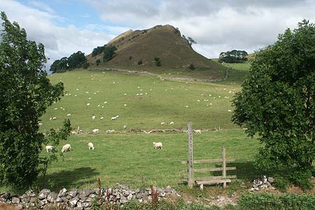
Lying just north of the infant River Dove these two remnants of a coral reef provide excellent walking with the benefit of great views. Chrome Hill has, for a long time, been a popular ascent. On the other hand, until the CROW Act provided improved access to the hills and countryside, Parkhouse Hill was always defended by "No Access" signs and was only climbed by those who wanted to defy the landowner's request. This route combines the two summits at the same time providing a taste of the limestone terrain that is prevalent north of the Dove in this part of Derbyshire.
The start of this excellent Peak District walk is the small village of Earl Sterndale where parking on the road outside the church (Grid ref. SK090670) is usually easy. The first part of the walk is a navigational challenge. Facing the "Quiet Woman" pub (Note the signs picturing a headless woman!), go right through the village recycling centre at the end of the pub and then through an alley. This crosses an access drive to a house before entering fields. The path crosses the field almost due west to pass by a wall end. It then continues through a gate with a water trough and across a field to a well-camouflaged wall stile. From here the path descends to the road (Grid ref. SK084668). Go across the first field to a gate and then go half right to a stile in the fence and continue to Glutton Grange Farm.
The onward path goes to the left of the farm house through a gate and leads north through a small dry valley to reach a track (Grid ref. SK082677). Turn left here and walk as far as a double gate. Here you go right to follow a well signed path down to a lane in Dowel Dale (Grid ref. SK075678). Turn right along the lane and continue for about a mile to reach the access drive to Stoop Farm (Grid ref. SK065683). Turn left down this track as far as a footpath sign. This directs you left along a concessionary path towards Chrome Hill. The waymarking is good and the National Park have done a good job negotiating with local farmers to provide this valuable access so until you have reached the Open Access area do not stray from the designated path.
Arriving at the foot of Chrome Hill you follow the main ridge path. This provides some spectacular views of the surrounding countryside especially along the Dove Valley and across to Hollins Hill and Staffordshire. A word of warning is necessary in wet weather as the limestone underfoot can be worse than ice in the wrong conditions. Having enjoyed the view, descend southeast along the ridge to a lane (Grid ref. SK076670). As you descend you can get a good look at Parkhouse Hill ahead. This is a little sister to Chrome Hill and provides a rather more challenging ascent than that on Chrome Hill.
Turn right along the lane and cross onto the grass. At the foot of Parkhouse Hill is a large cone of limestone. Go to the right of this and locate a narrow path that climbs steeply to reach a point between the cone and the main hill. The path then continues to climb with some short scrambles along the crest of Parkhouse Hill to reach its summit. With a few exceptions you can avoid the worst of the scrambling to the right of the crest. Once you have gained the summit descend over grass and the occasional small limestone outcrop to a gate (Grid ref. SK082669). Cross this field, used on the outward route, to the road and then make the ascent back into Earl Sterndale perhaps taking advantage of the refreshments on offer in the "Quiet Woman".
Other walks nearby
| Walk 1862 | Earl Sterndale and High Wheeldon from Longnor | easy/mod | 6.0 miles |
| Walk 2723 | Pilsbury Castle, Hartington & Sheen from Longnor | easy/mod | 9.6 miles |
| Walk 1185 | Chrome Hill (Dragon's Back) from Hollinsclough | easy/mod | 4.5 miles |
| Walk 2531 | Upper Dove Valley | moderate | 7.5 miles |
| Walk 2545 | High Edge & Chrome Hill from Hollinsclough | moderate | 8.5 miles |
| Walk 2837 | Parkhouse & Chrome Hills from Longnor | easy/mod | 6.7 miles |
| Walk 3445 | The Dragon's Back (Chrome Hill) from Hollinsclough | moderate | 4.5 miles |
| Walk 3709 | Sparklow, Crowdicote & Pilsbury Circular | easy/mod | 9.0 miles |
| Walk 1043 | Chelmorton & the Monsal Trail | easy/mod | 8.1 miles |
| Walk 1146 | Bradford & Lathkill Dales | moderate | 11.3 miles |
Recommended Books & eBooks
Great Mountain Days in the Pennines
 An inspirational guidebook to 50 classic walks on the rolling Pennine landscape. The graded routes, between 6 and 13 miles in length, cover classic Pennine fells and moorland such as Whernside, Ilkley Moor and Pendle Hill; exploring the North and South Pennines, Yorkshire Dales, Howgills and Dark Peak. Many routes are also suited to fell running.
More information
Walking in Derbyshire
 Walking guidebook to 60 circular day walks in Derbyshire and the Peak District. Includes the Derwent, Wye and Trent river valleys, near Derby, Matlock, Glossop, Bakewell and Ripley. Routes range from easy to moderate and are between 4 and 14km (2 to 10 miles). Walks focus on places of interest, from Stone Age forts to castles to grand estates.
More information
Messaging & Social Media
Message Walking Britain and follow the latest news.

Mountain Weather
Stay safe on the mountains with detailed weather forecasts - for iOS devices or for Android devices.