Snowdon via the Watkin Path & South Ridge from Bethania
Snowdonia/Eryri Walk
Nat Park - Snowdonia - Snowdon Crib Goch
County/Area - Gwynedd
Author - Lou Johnson
Length - 8.0 miles / 13 km Ascent - 3400 feet / 1030 metres
Time - 7 hours 20 minutes Grade - mod/hard
Maps 

| Ordnance Survey Explorer OL17 | Sheet Map | 1:25k | BUY |
| Anquet OS Explorer OL17 | Digital Map | 1:25k | BUY |
| Ordnance Survey Landranger 115 | Sheet Map | 1:50k | BUY |
| Anquet OS Landranger 115 | Digital Map | 1:50k | BUY |
Walk Route Description
Click image to visit gallery of 3 images.
This ascent of Snowdon is very popular although, because of its nature, it does not attract occasional walkers as much as the routes from Pen-y-pass and Llanberis. The going is steady with generally good paths although see comments in the description regarding this matter. The walk in provides a grandstand view of the southern aspect of Snowdon and makes you realise what an impressive mountain it is.
This Snowdonia (Eryri) walk starts from the car park at Bethania (grid ref. SH627506), on the A498 Beddgelert to Capel Curig road. Recently police have been giving tickets to those parking on the grass verges adjacent to the car park, which is often full on fine days. Another option is to park in Beddgelert and catch the bus. Cross the main road and walk back towards Beddgelert for a few hundred metres and take the signed track that heads north. This is the start of the Watkin Path.
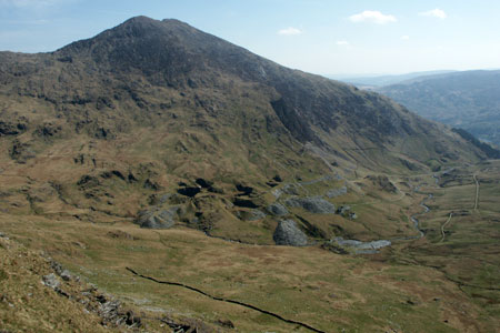
The old mine track climbs steadily with ever improving views. On your right are the waters of Afon Cwm Llan and the waterfalls can be very dramatic especially after heavy rain. After about a mile you enter the dramatic Cwm Llan with the steep southern slopes of Snowdon providing a dramatic backdrop to the scene.
As the view opens up, continue following the main path with the river on your right. Reaching a junction of paths (grid ref. SH620520) the path coming in from your left will be used later in the day. Ignore this and continue straight ahead to cross a footbridge. The path meanders a little, passes the Gladstone Rock, and shortly afterwards starts to climb in earnest. The path is generally good and you feel you are making progress although you will shortly realise that this is perhaps not as good as you had hoped.
Reaching the ridge at a col, Bwlch Ciliau (grid ref. SH619537), between Snowdon on your left and Y Lliwedd on your right, you get first views across the rocky cwms on Snowdon's eastern flank. Far below lies Llyn Llydaw with Glaslyn higher up the valley. As suggested progress so far has been good but you still have about 340 metres (1000 feet) to climb so the col makes an ideal place for a final rest before pushing on to the summit. The section of path from here is not a favourite of mine. It is a tedious climb on a nasty path that is often loose and slippery after rain. It is also a path that has seen its fair share of accidents, so do take care. Please note that in winter with snow on this section that high levels of skill and the correct equipment are required to complete this section.
In places the onward route is not too clear and it is important that you make sure you stay with the intended route. In mist you have significant crags to your left whilst if you stray too far to your right you have steep cliffs dropping into Glaslyn. This is not the place to make rash decisions so do be careful. The path climbs in zigzags in its latter stages to bring you onto Snowdon's South Ridge above Bwlch Main (grid ref. SH609542). Turn right and continue the short walk to Snowdon's summit where no doubt you will meet the hordes!
The descent follow the South Ridge so retrace your steps down hill and pass the point where you joined the ridge. Continue across airy Bwlch Main to reach a junction of paths (grid ref. SH604536). The Rhyd-Ddu Path veers right here and we continue straight ahead losing height quite quickly. During this descent Y Aran dominates the view ahead. Reaching a col, Bwlch Cwm Llan (grid ref. SH604521), turn left and descend steeply at first into Snowdon's South Cwm. This path rejoins the Watkin Path (grid ref. SH620520) where you bear right and retrace your steps back down to Bethania car park.
Other walks nearby
| Walk 3058 | Llyn yr Adar & Llyn Edno from near Bethania | moderate | 9.0 miles |
| Walk 1427 | Craflwyn circular from near Beddgelert | easy/mod | 2.5 miles |
| Walk 2150 | Llyn Dinas and Cwm Bychan from Beddgelert | easy/mod | 6.0 miles |
| Walk 2560 | Moel Hebog, Moel yr Ogof & Moel Lefn from Beddgelert | mod/hard | 6.5 miles |
| Walk 1799 | Moel Hebog | moderate | 5.5 miles |
| Walk 1988 | Beddgelert, Moel Hebog, Meol yr Ogof & Moel Lefn | mod/hard | 6.8 miles |
| Walk 3074 | Mynydd Sygun | moderate | 4.5 miles |
| Walk 3231 | Moel Hebog, Meol yr Ogof and Moel Lefn from Beddgelert | mod/hard | 6.8 miles |
| Walk 1426 | Aberglaslyn and Cwm Bychan | easy/mod | 5.8 miles |
| Walk 1089 | Snowdon by the Pyg and Miner's Tracks | moderate | 7.5 miles |
Recommended Books & eBooks
The Cambrian Way
 Guidebook to the Cambrian Way, a challenging three-week mountain trek through Wales from Cardiff to Conwy. The 470km un-waymarked route is presented from south to north. Often sticking to long, beautiful ridgelines, it crosses wild and rugged terrain and visits many of Wales's highest mountains, including Snowdon.
More information
Snowdonia: 30 Low-level and easy walks - North
 Guidebook describing 30 walks in Snowdonia, Wales. Routes are mostly low level and on clear paths and showcase the region's beautiful scenery and rich history and culture. Part of a 2-volume set, this northern volume includes the Snowdon area, the Ogwen and Conwy Valleys, Betws-y-Coed, Beddgelert, Ffestiniog and the coast.
More information
Messaging & Social Media
Message Walking Britain and follow the latest news.

Mountain Weather
Stay safe on the mountains with detailed weather forecasts - for iOS devices or for Android devices.