The River Derwent, Curbar, Baslow & Froggatt Edges
Peak District Walk
Nat Park - Peak District - Gritstone Edges Higger Tor
County/Area - Derbyshire
Author - Mike Bexley
Length - 7.5 miles / 12.2 km Ascent - 890 feet / 270 metres
Time - 4 hours 40 minutes Grade - easy/mod
Maps 

| Ordnance Survey Explorer OL24 | Sheet Map | 1:25k | BUY |
| Anquet OS Explorer OL24 | Digital Map | 1:25k | BUY |
| Ordnance Survey Landranger 119 | Sheet Map | 1:50k | BUY |
| Anquet OS Landranger 119 | Digital Map | 1:50k | BUY |
Walk Route Description
Click image to visit gallery of 2 images.
A Peak District walk for any season. Starting in woodland, it follows the deeper stretches of the River Derwent returning to high ground to look down on the river with spectacular views over the Chatsworth Estate and the village of Eyam. The start is a small car park (grid ref. SK255777) at Hay Wood off the B6054 near the Grouse Inn. Another walk of totally different character starts from this same car park - walk 2520. The unmarked lane entrance to the car park is on the road north of Froggatt village, just prior to 'The Grouse Inn'. From the car park head downhill through the woods in a westerly direction taking the steeper left path at the fork. Follow this down through the woods and lanes to reach the River Derwent at a road bridge (grid ref. 245778).
Do not cross over the bridge but take the path left just before the bridge. Cross the field diagonally towards the woods in the left corner of the field. Continue to follow a clear path through the woods leading to Spooner Lane and then Froggatt village (grid ref. 243763). Keep straight on to the river, do not cross over instead taking the path that starts with a narrow gap in the wall entrance to the left of the river.
This path follows the river and on reaching the road cross over to continue this lovely riverside stroll until it ends at another road. Continue on the road in the same direction to Calver (grid ref. 247744). The large Mill building across the river on you right was the 'prison' in the television series 'Colditz'.
At the road junction turn left up the hill (this is a steep pull) and at the cross roads with its telephone box turn right to take the narrow footpath on the left through the wall between houses. On reaching a lane turn right. At the end of the lane (grid ref. 252741) head uphill keeping to the right of the large trees following the path to the second wall. On reaching this point turn sharp left and follow the wall to reach the entrance into a small wood. Go through the wood and up on to a very wide path. Turn right and follow this path uphill, keeping to the left of the wall (do not go through the gate) and through a small quarry to the top path bearing left.
To the right of you is Wellington's Monument, well worth the visit for the views over Chatsworth. It is said, but not proved, that it was built to commemorate Wellington's visit to this area. Not to be out-done opposite you on the distant southeast ridge, there is a another monument, to Nelson, built five years after his battle at Trafalgar.
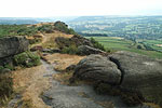
Return to the path by cutting across the moor to the very large stone named Eagle Stone (grid ref. 262740). Legend has it that the young men of Baslow proved how fit they were for marriage by climbing to the top. There certainly were a lot of marriages but it was thought due to them finding an easy way up! The path now heads North at first along Baslow Edge to dip down to cross a road before continuing along Curbar Edge. All the time you have wonderful views on your left and flat moors on your right. It finishes through some trees at a road where you cross over down to a small stream and up the other side to the car park.
Mike has led 'Mike's Hikes' for the last 4 - 5 years, since leaving Mountain Rescue where he was based in Hayfield as part of the Kinder MRT. E-mail "Mike's Hikes"
Other walks nearby
| Walk 1093 | Higger Tor & Burbage Rocks | easy/mod | 5.3 miles |
| Walk 1240 | Curbar, Froggatt & White Edges | easy/mod | 8.0 miles |
| Walk 1169 | Baslow Edge & Wellington's Monument | easy | 3.5 miles |
| Walk 1014 | Coombs Dale, Longstone Edge & Pilsley from Calver | moderate | 10.0 miles |
| Walk 2548 | Stanage Edge from Hathersage | moderate | 8.5 miles |
| Walk 1539 | Flask Edge and Bar Brook Moor from Shillito Wood | moderate | 9.4 miles |
| Walk 1270 | Abney Circular | easy/mod | 7.2 miles |
| Walk 3620 | Bretton Clough & Abney Moor | easy/mod | 6.0 miles |
| Walk 1479 | Burbage Moor & Redmires from near Ringinglow | easy/mod | 9.8 miles |
| Walk 1100 | Abney Moor & Bretton Clough | moderate | 8.5 miles |
Recommended Books & eBooks
Great Mountain Days in the Pennines
 An inspirational guidebook to 50 classic walks on the rolling Pennine landscape. The graded routes, between 6 and 13 miles in length, cover classic Pennine fells and moorland such as Whernside, Ilkley Moor and Pendle Hill; exploring the North and South Pennines, Yorkshire Dales, Howgills and Dark Peak. Many routes are also suited to fell running.
More information
Walking in Derbyshire
 Walking guidebook to 60 circular day walks in Derbyshire and the Peak District. Includes the Derwent, Wye and Trent river valleys, near Derby, Matlock, Glossop, Bakewell and Ripley. Routes range from easy to moderate and are between 4 and 14km (2 to 10 miles). Walks focus on places of interest, from Stone Age forts to castles to grand estates.
More information
Messaging & Social Media
Message Walking Britain and follow the latest news.

Mountain Weather
Stay safe on the mountains with detailed weather forecasts - for iOS devices or for Android devices.