Stanage Edge from Hathersage
Peak District Walk
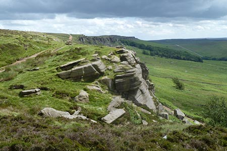
Nat Park - Peak District - Gritstone Edges Higger Tor
County/Area - Derbyshire
Author - Nick O'Brien
Length - 8.5 miles / 13.8 km Ascent - 1600 feet / 485 metres
Time - 5 hours 50 minutes Grade - moderate
Maps 

| Ordnance Survey Explorer OL1 | Sheet Map | 1:25k | BUY |
| Anquet OS Explorer OL1 | Digital Map | 1:25k | BUY |
| Ordnance Survey Landranger 110 | Sheet Map | 1:50k | BUY |
| Anquet OS Landranger 110 | Digital Map | 1:50k | BUY |
Walk Route Description
Click image to see photo description.
This Peak District walk is aimed at those who may not have their own transport and starts from the busy little village of Hathersage, which is served by bus and rail services. The route wanders north through farmland onto the moors before climbing up onto the Stanage Edge escarpment. On the way back we visit the grave of Little John, one of Robin Hood's men.
Start in the village of Hathersage (Grid ref. SK231815) heading north alongside the river to the footbridge. Cross over the river and walk diagonally up the fields through the woods to Birley Farm (Grid ref. 226824). From here follow the direction signs to the right of the buildings to reach the road. Turn left on the road then left again at the footpath down to Nether Hurst (Grid ref. 222828). Take the left bridleway to Hurstclough Lane turning right to Gatehouse. Just before reaching Gatehouse Farm take the footpath on the left that heads north up the fields. You can continue to proceed all the way up the fields but the path is unclear and often fenced, so I turn right at the path junction to the visible buildings of Outlane (Grid ref. 225836).
On reaching the road at Outlane, turn left, then left again at the path sign. This high path at first doubles back then sweeps round, northwest, through the woods to join the road (Grid ref. 220840). Turn left along the road then right at the footpath climbing up to a disused quarry. Exit north. The footpath starts clearly but tends to become feint and overgrown as you proceed across Bamford Moor. In low cloud a compass is a necessary. Keep heading north until you reach the remains of a wall, then Northeast to the cliff face of Stanage Edge. Head for the lowest and easiest place to ascend, Crow Chin (grid ref 224856), to the left of the high visible rocks of High Neb.
On reaching the top, turn right (south east) keeping to the magnificent edge then descending right at the 'Long Causeway' path junction (grid ref 238846). The path drops down through woods and a car park to the road. Turn left along the road, then right at the footpath just after the low building. The path descends (ignore the gated private path on the left down to the brook) via North Lees to the road (Grid ref. 234831). Turn left passing the farm drive to the high path on the right. Head straight on south following the fence to pass Cowclose (Grid ref. 234829) until the path descends down a field to join a path from the right.
Turn left over the brook climbing up to the church. Little John's grave is in the churchyard to the left (east) of the church. Keep to the path that passes the grave through the church grounds turning right just after the exit. The path follows the wall on the right, down to a lane. Turn left into Hathersage and the starting point.
Other walks nearby
| Walk 1090 | Stanage Edge | moderate | 7.0 miles |
| Walk 1270 | Abney Circular | easy/mod | 7.2 miles |
| Walk 3620 | Bretton Clough & Abney Moor | easy/mod | 6.0 miles |
| Walk 1093 | Higger Tor & Burbage Rocks | easy/mod | 5.3 miles |
| Walk 1273 | Burbage Rocks & Padley Gorge from Hay Wood | moderate | 11.0 miles |
| Walk 2515 | The River Derwent, Curbar, Baslow & Froggatt Edges | easy/mod | 7.5 miles |
| Walk 2520 | Higger Tor & the Longshaw Estate | moderate | 9.0 miles |
| Walk 2588 | Win Hill & Hope Cross | moderate | 7.5 miles |
| Walk 1541 | Redmire, Stanage & Ughill Moor circular | moderate | 13.0 miles |
| Walk 1479 | Burbage Moor & Redmires from near Ringinglow | easy/mod | 9.8 miles |
Recommended Books & eBooks
Walking in Derbyshire
 Walking guidebook to 60 circular day walks in Derbyshire and the Peak District. Includes the Derwent, Wye and Trent river valleys, near Derby, Matlock, Glossop, Bakewell and Ripley. Routes range from easy to moderate and are between 4 and 14km (2 to 10 miles). Walks focus on places of interest, from Stone Age forts to castles to grand estates.
More information
Dark Peak Walks
 Guidebook to 40 walks in the Dark Peak area of the Peak District National Park. 35 circular routes for most abilities, from 8km to 19km, around Edale, Marsden, Fairholmes, Baslow and Castleton, including Kinder Scout and Mam Tor, and 5 longer (25km to 45km) routes highlighting the best of the Gritstone Edges, High Moorland and Deep Valleys.
More information
Messaging & Social Media
Message Walking Britain and follow the latest news.

Mountain Weather
Stay safe on the mountains with detailed weather forecasts - for iOS devices or for Android devices.