The Storr & Old Man of Storr from Loch Leathan
Highland Walk
County/Area - Highland - Isle of Skye
Author - Stephen Boulton
Length - 5.5 miles / 8.9 km Ascent - 2500 feet / 758 metres
Time - 5 hours 20 minutes Grade - moderate
Maps 

| Ordnance Survey Explorer 408 | Sheet Map | 1:25k | BUY |
| Anquet OS Explorer 408 | Digital Map | 1:25k | BUY |
| Ordnance Survey Explorer 409 | Sheet Map | 1:25k | BUY |
| Anquet OS Explorer 409 | Digital Map | 1:25k | BUY |
| Ordnance Survey Landranger 23 | Sheet Map | 1:50k | BUY |
| Anquet OS Landranger 23 | Digital Map | 1:50k | BUY |
Walk Route Description
Click image to visit gallery of 9 images.
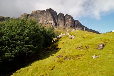
The Old Man of Storr rises to 535 metres and is visible from the main road between Portree and Staffin on the west coast of Skye. Dominating the scene and visible from many more parts of the islands the Storr is the hill immediately west of the Old Man and rising to 719 metres with dramatic cliffs on its eastern flank.
There is a small car park opposite Loch Leathan (Grid ref. NG509529) on the west side of the A855 heading north from Portree to Staffin. From here a refurbished path leads up through the woods to emerge below the Old Man of Storr.
You can scramble up to the base of the Old Man, although the heavily eroded slopes leading up to it suggest you would not be the first person to do so. The rock architecture is superb, lots of pinnacles backed by the imposing cliffs of The Storr. To reach the summit of The Storr we walked north, contouring across the top of Coire Scamadal to a point at about grid ref. NG 494553, whereupon we turned back on ourselves to head south across the easy, grassy rise to The Storr's summit cairn.
A short walk east from the trig point takes you to the cliff edge and a wonderful view over the pinnacles below and out over Loch Leathan and over Dun Caan on Raasay and further to the mainland. On the day we were there you could clearly make out the Five Sisters of Kintail.
From the summit we walked west south west for a hundred metres or so to avoid the top of an obvious gully (might not be so obvious in the mist or snow though), then turned south and then south east to follow the rim of Coire Faoin with the Old Man coming into view again as we descended.
At Bealach Beag we picked up a burn and followed this down through the crags at about grid ref. NG 493531 (steep in places, probably not very easy in snow & ice) to emerge on grassy land which we followed to a stile in the fence by the road at about grid ref NG 503525. From there we turned left and it was a short walk of about 600 metres or so back to the car park. A fine day out.
Other walks nearby
| Walk 1165 | The Quirang | easy | 3.2 miles |
| Walk 2002 | Dun Caan, Isle of Raasay | moderate | 10.6 miles |
| Walk 3760 | Glamaig (Sgurr Mhairi & An Coileach) | mod/hard | 4.5 miles |
| Walk 2589 | Marsco | moderate | 8.7 miles |
| Walk 3216 | Sgurr a'Ghreadaidh and Sgurr na Banachdich | very hard | 5.5 miles |
| Walk 2197 | The Inaccessible Pinnacle and Sgurr Mhic Choinnich | very hard | 6.0 miles |
| Walk 1167 | Glen Brittle & Coire Lagan | moderate | 4.6 miles |
| Walk 3753 | Blabheinn via south ridge | mod/hard | 8.0 miles |
| Walk 1344 | Beinn Alligin & Sgurr Mor | mod/hard | 6.0 miles |
| Walk 1166 | Loch Coruisk | easy | 4.0 miles |
Recommended Books & eBooks
Walking in Torridon
 This guidebook contains 52 day walks in Torridon, a remote and much-loved area of the Scottish Highlands. Based around Shieldaig and Slioch, the routes are split into 3 sections: easy walks, long and high level walks and mountain ascents over 2000ft including 9 Munros, and 5 outline suggestions for major ridge walks.
More information
Walking the Munros Vol 2 - Northern Highlands and the Cairngorms
 Guidebook to walking the northern Munros, covering the northern Highlands, the Cairngorms and the Isle of Skye. 70 routes are described, including those up Ben Macdui, Braeriach and Cairn Gorm. Routes range from 7 to 46km, requiring a fair level of fitness. The second of two guidebooks to walking Scotland's Munros: peaks higher than 3000ft.
More information
Messaging & Social Media
Message Walking Britain and follow the latest news.

Mountain Weather
Stay safe on the mountains with detailed weather forecasts - for iOS devices or for Android devices.