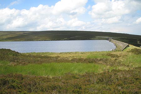
Keighley Moor Reservoir & Hitching Stone from Cowling
South Pennines Walk
Region - South Pennines
County/Area - North Yorkshire & West Yorkshire - South Pennines
Author - Allan Friswell
Length - 9.5 miles / 15.4 km Ascent - 1450 feet / 439 metres
Time - 6 hours 10 minutes Grade - moderate
Maps 

| Ordnance Survey Explorer OL21 | Sheet Map | 1:25k | BUY |
| Anquet OS Explorer OL21 | Digital Map | 1:25k | BUY |
| Ordnance Survey Landranger 103 | Sheet Map | 1:50k | BUY |
| Anquet OS Landranger 103 | Digital Map | 1:50k | BUY |
Walk Route Description
Click image to visit gallery of 5 images.
This route explores the moors lying between Cowling and Keighley. Sections of the last few miles are a bit of a balancing act at times as you avoid the bogs. However notwithstanding this minor difficulty the walk offers wide ranging views and a sense of wilderness.
The start is the Post Office in the village of Cowling (Grid ref. SD973431). Park with consideration in one of the side streets. After parking walk up the main road for about half a mile to the former Black Bull PH, now a furniture shop. Cross the road and go through the gate, then climb steeply but briefly up the slope to another rusty kissing gate. Cross the next field at to the gap in the wall. Then climb to the squeeze stile and gate in the corner just above the house. Cross the lane and take the stile. Follow the left hand wall via a kissing gate to a step/squeeze stile and turn left along the lane.
Bear right at the T-junction (Grid ref. SD965422). You are now on the Pennine Way. When you arrive at a gate, go through it and climb the track that runs alongside a small ravine with a charming waterfall at its head. The track hairpins back on itself (Grid ref. SD 965419). Follow the track downhill, past a signpost and through a gate (Grid ref. SD965418). Continue down some stone steps, over the single slab bridge and continue along the path over some rather boggy ground. At the fence go downhill, keeping to the right; cross the footbridge and climb the steps on the other side (Grid ref. SD 970 417).
Continue up hill. You pass a deserted farmhouse on your left. Go through the gap in the wall and climb a very steep few yards. Follow the right hand wall until you reach a (usually flooded!) step stile at grid ref SD972417. Cross this. The path is now very boggy, but you follow it, making for a cabin with a chimney, and a Pennine Way signpost to the side of it. You then cross a beck and make for a shooting cabin with benches outside to sit and admire the moorland views (Grid ref. SD 969 415). Cross the beck and follow the fairly distinct path running roughly parallel with the wall. Then you arrive at a signpost by a new metal gate (Grid ref. SD969412). You have now done just over 2.5 miles.
Head up hill towards a second substantial shooting cabin (Grid ref. SD969411). Follow the path uphill, passing a shooting cabin on your right, and then descending past the right of yet another cabin made of stone. The path is now slabbed and provides an easy ascent up the gentle moorland slope. Eventually the slabs come to an end. The path carries on and reaches the area (Grid ref. SD972402) where the slabs start once more and then stop again, as though someone really could not be bothered with all this. The path is still pretty clear, if boggy, and at grid ref. SD974395 it becomes slabbed again.
Finally you arrive at the end of a wall (Grid ref. SD979389) with a marker post saying "Millennium Walk". (You have done about 4.25 miles). Turn left and follow the clear track and waymarker posts all the way down to little Keighley Reservoir (Grid ref. SD989392), 5 miles from your start point. Cross the dam, following the Millennium Way now (path 10) and turn right along the tarmacked access road. Follow this for a mile all the way down to Morkin Bridge car park via a gate at Higher Intake Farm (Grid ref SE002403). Turn left, crossing the bridge and walk up the hill to Middle Slippery Ford Farm, where you take the footpath on the left which doubles back in the direction you have just come from.
The track is very clear, with walls on either side. Go through the gate at grid ref. SD999407. The track follows the right hand wall. Pass through a gate, over a bridge by a waterfall, then over the stile (or through the gate) and pass across the front of the deserted farmhouse. The path ahead is very tempting, but do not take it. (I did - and discovered the "pleasures" of floundering in peat bogs!) Instead go right, along the side of the house and follow the wall, which soon bears to the left. After about half a mile there is a wire fence across the path (part of the wall has fallen down), but with one section removed as if to provide a way through. Do not go through this I (we did and came to a cul de sac between fence and wall) but bear left with the fence on your right and you should shortly rejoin the path. Continue for about half a mile until you arrive at the Hitching Stone (Grid ref. SD986417). Initially there is no sign of a path, but it eventually appears and remains clear.
The Hitching Stone is reputed to be Yorkshire's largest boulder. It sits all alone, a geological oddity, on the crest of a hill. Estimated to weigh 1,000 tons, it measures 29 feet long, 25 feet wide and 21 feet high. The stone is of glacial origin and almost certainly originated on Earl Crag above Cowling. On the north-western side, there is evidence of a "tube", which runs throughout the length of the rock. Geologists believe it is caused by a fossilised tree (called Lepidodendron) that has since eroded away, leaving the "tube". The stone is a primary landmark and was thus used in organising the land. It marks the boundary between Yorkshire and Lancashire, the townships of Cowling, Sutton and Keighley meet here, as do the wapentakes (an assembly or meeting place) of Skyrack (Leeds) and Staincliffe (Keighley, Settle, Skipton, Stainburn). The Hitching Stone is therefore an important boundary marker. This link gives more details.
From the stone (at which point you have done around 7.5 miles) continue on the same line downhill, keeping the wall and fencing on your right. The path here is reinforced - by a blind man, it seems. Play hopscotch with the little irregular slabs. Go through the gate and carry on uphill on rather drier ground to the gate in the corner. Maintain this line until you reach the road. Turn left, then go through the car park on your right (Grid ref. SD985426), and follow the path heading straight for Wainman's Pinnacle. Pause here and admire the spectacular views across, from the left, Cowling, Glusburn and Cross Hills. Suddenly the slogging of the past hour seems worth it!
Wainman's Pinnacle was built in 1816 by a local farmer, Richard Wainman, in celebration of the Battle of Waterloo and, more poignantly, in memory of his son killed in the Napoleonic Wars. To the right, at the other end of the Crag, is Lund's Tower, a folly built in 1897 by James Lund of Malsis Hall (now a private school) to celebrate Victoria's Golden Jubilee and / or his daughter's 21st birthday. It is also known as Ethel's Tower, and it and the Pinnacle are known locally as Salt and Pepper.
Turn left and follow the path along the crest of Earl's Crag. After about 1/2 mile there is a clear path zigzagging down the hill. Follow this all the way to the road at the foot. Turn left here, and follow the road. Where the road bends right, take the footpath on the left into the farmyard and immediately cross the stile and gate on the right. The path goes down the left hand side of the field, then to the right of the big Ash tree and to the corner of the field. Pass through the gate, cross the small close of council housing to the main road, turn left and walk back to the Post Office.
Other walks nearby
| Walk 2861 | Pinhaw Beacon from Lothersdale | easy | 4.0 miles |
| Walk 2904 | Cross Hills to Skipton via Low Bradley | easy/mod | 6.5 miles |
| Walk 3430 | Farnhill Moor from Kildwick | easy/mod | 4.5 miles |
| Walk 2657 | Bradleys Both, near Skipton | easy/mod | 5.5 miles |
| Walk 3215 | Steeton to Ilkley without a car | moderate | 7.5 miles |
| Walk 3079 | Silsden Reservoir circular | easy | 6.0 miles |
| Walk 1135 | Top Withins and the Bronte Bridge | moderate | 8.0 miles |
| Walk 1585 | Haworth Moor circular | easy | 5.0 miles |
| Walk 1243 | Haworth Moor and Bronte Bridge from Oxenhope | easy | 3.5 miles |
| Walk 2942 | Below Silsden Moor | easy/mod | 6.8 miles |
Recommended Books & eBooks
The Pennine Way
 Guidebook to the Pennine Way National Trail with OS map booklet. The 265 mile route from Edale to Kirk Yetholm takes three weeks to walk and is suitable for fit and experienced long distance walkers. The route crosses the Peak District, Yorkshire Dales and North Pennines National Parks. Includes separate OS 1:25,000 map booklet of the route.
More information
The Pennine Way - the Path, the People, the Journey
 A portrait of the The Pennine Way, Britain's oldest and best known long-distance footpath, stretching 268 miles from the Peak District to the Scottish Borders. This personal, thoughtful and often humorous story of the path's remarkable history, includes the experiences of walkers and local characters on this exhilarating and complex path.
More information
Messaging & Social Media
Message Walking Britain and follow the latest news.

Mountain Weather
Stay safe on the mountains with detailed weather forecasts - for iOS devices or for Android devices.