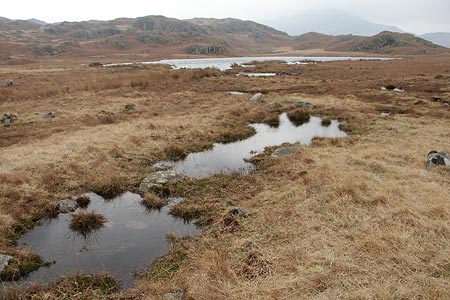
Eel Tarn and Stony Tarn from Eskdale
Lake District Walk
Nat Park - Lake District - Lake District Southern Fells
County/Area - Cumbria
Author - Lou Johnson
Length - 6.0 miles / 9.8 km Ascent - 1350 feet / 409 metres
Time - 4 hours 20 minutes Grade - easy/mod
Maps 

| Ordnance Survey Explorer OL6 | Sheet Map | 1:25k | BUY |
| Anquet OS Explorer OL6 | Digital Map | 1:25k | BUY |
| Ordnance Survey Landranger 90 | Sheet Map | 1:50k | BUY |
| Anquet OS Landranger 90 | Digital Map | 1:50k | BUY |
Walk Route Description
Click image to visit gallery of 5 images.
This half day Lake District walk combines visits to two tarns with some rugged Lakeland terrain. The views in good weather are excellent for relatively little ascent. In poor weather, navigation can be problematic as the landscape has few obvious landmarks
This Lakeland walk starts from the small car park on the north side of the road from Eskdale to Hardknott Pass at Wha House Farm (Grid ref. NY201009). After parking walk east towards the River Esk. Cross the bridge and take the signed footpath on your right. This follows the river for a short way before entering woodland. Keep right at the junction (Grid ref. NY203005) and continue past Penny Hill Farm to cross the River Esk using Doctor Bridge (Grid ref. NY189007). Having reached the far bank, turn right along the path to reach the road just to the west of the Woolpack Inn.
Turn right along the road towards the Inn and take the signed path up the lane to the immediate left of the Inn. Going through the intake wall at a gate, follow the green path uphill to reach Eel Tarn, which lies to the right of the path. Continue to the northern end of the tarn, cross the outflow and go right onto the green path going southeast (Grid ref. NY188020). This path occasionally fades but by keeping the higher ground on your right Stony Tarn soon comes into view in a large depression on your right.
Stay on the path following it north-east towards the Scafells. Continue past Cat Cove (Grid ref. NY202034) for approximately 400 metres before leaving the path and heading east across unpathed territory to reach the main Scafell path. Once this is reached turn right and it is an easy descent back to the start near Wha House Farm.
Other walks nearby
| Walk 2226 | The Scafells | very hard | 12.0 miles |
| Walk 1916 | Harter Fell and Low Birker Tarn from Hardknott Pass | moderate | 6.5 miles |
| Walk 3419 | Scafell Pike an Eskdale circular | very hard | 12.5 miles |
| Walk 2467 | Green Crag & Harter Fell | moderate | 7.9 miles |
| Walk 2355 | Blea Tarn & Eskdale Green | easy/mod | 6.5 miles |
| Walk 1668 | Silver Knott & Muncaster Fell from Irton Road | easy/mod | 5.0 miles |
| Walk 3485 | High Birkhow & Low Wood from Wast Water | easy | 4.2 miles |
| Walk 1176 | Yewbarrow | moderate | 4.5 miles |
| Walk 2341 | Circuit of Nether Beck and Over Beck from Wasdale | hard | 11.3 miles |
| Walk 1690 | Netherbeck Horseshoe - Middle Fell, Steeple & Red Pike from Wasdale Head | mod/hard | 12.5 miles |
Recommended Books & eBooks
Great Mountain Days in the Lake District
 An inspirational guidebook to 50 challenging walks on the high fells of the Lake District. The graded circular routes, between 4 and 14 miles in length, cover classic Lakeland summits like Fairfield, Scafell Pike, Great Gable and Blencathra, to the lesser-known High Spy, King's How and Brund Fell.
More information
Walking the Lake District Fells - Langdale
 Part of the Walking the Lake District Fells series, this guidebook covers a wide range of routes to 25 Lakeland summits that can be climbed from the Great Langdale valley, Ambleside and Grasmere, with highlights including Scafell Pike, Bowfell, the Langdale Pikes and Helm Crag (the Lion and the Lamb). Includes suggestions for longer ridge routes.
More information
Messaging & Social Media
Message Walking Britain and follow the latest news.

Mountain Weather
Stay safe on the mountains with detailed weather forecasts - for iOS devices or for Android devices.