Tyrrau Mawr and Craig-y-llyn from Llanfihangel-y-pennant
Snowdonia/Eryri Walk
Nat Park - Snowdonia - Cadair Idris
County/Area - Gwynedd
Author - Lou Johnson
Length - 9.5 miles / 15.4 km Ascent - 2650 feet / 803 metres
Time - 7 hours 20 minutes Grade - moderate
Maps 

| Ordnance Survey Explorer OL23 | Sheet Map | 1:25k | BUY |
| Anquet OS Explorer OL23 | Digital Map | 1:25k | BUY |
| Ordnance Survey Landranger 124 | Sheet Map | 1:50k | BUY |
| Anquet OS Landranger 124 | Digital Map | 1:50k | BUY |
Walk Route Description
Click image to visit gallery of 9 images.
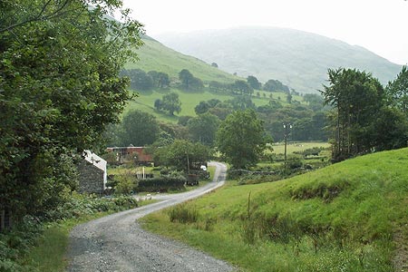
This excellent walk in the Southern sector of the Snowdonia (Eryri) National Park offers some excellent views across Barmouth and the Mawddach Estuary. The paths are quiet and see far fewer people than neighbouring Cadair Idris, which lies to the immediate east along the ridge. The main objectives of the walk are the summits of Tyrrau Mawr and Craig-y-llyn both of which are flanked by steep crags on their northern side.
Limited parking is available on the verge just before the bridge over the Afon Cadair (Grid ref. SH673095) or in the village car park at Llanfihangel-y-pennant which adds a little extra mileage to the walk. Cross the bridge over the Afon Cadair and bear right following the track signed to Cadair Idris. This climbs steadily up the valley to reach a ford just past Hafotty Gwastadfryn from where the route steepens briefly before easing for the climb up to the col east of Carnedd Lwyd. From here the views open out and you get a grand panorama looking north to the southern Rhinogs and beyond.
At the col turn left and leave the many walkers heading east to the summit of Cadair Idris. The path climbs over the rocky summit of Carnedd Llwyd to reach the first objective of the day - Tyrrau Mawr with its north facing steep crags. From here the view is excellent especially over Barmouth and the river estuary.
Having enjoyed the view, continue westwards following the fence as you first descend and then ascend onto the summit of Craig-y-llyn again with a line of north-facing crags that drop down to Llyn Cyri far below. Continue west, descending to a broad col (Grid ref. SH654114). Turn south here to locate the track that follows the right of way south into the valley. Some detective work is required to locate this path but once found it will lead you to a wall corner (Grid ref. SH656106). From here the line of the path is easier to follow using the OS map and you soon reach the valley floor and Nant-Cawr-fawr farm.
Go through the farm and continue along the lane to Bodilan Fach and a chapel. Cross the stile to left of the chapel and continue across pastures to Maes-y-llan. If you have parked in the village car park then cross the river here and continue along the lane to the village and car park. If you have parked on the verge beside the river, then stay on the path and continue to the bridge crossed at the start of the day.
Other walks nearby
| Walk 1643 | Llanfihangel-y-pennant & Castell y Bere | easy/mod | 6.8 miles |
| Walk 3582 | Castell y Bere & Llanfihangel-y-pennant from Abergynolwyn | easy/mod | 5.7 miles |
| Walk 1309 | Tarren y Gesail | moderate | 8.0 miles |
| Walk 3230 | Tarrenhendre from Abergynolwyn | easy/mod | 5.0 miles |
| Walk 1851 | Cregennen Lakes & Pared y Cefn-hir | easy/mod | 2.5 miles |
| Walk 1172 | Cadair Idris by the Pony Path | mod/hard | 11.0 miles |
| Walk 2668 | Cadair Idris, Craig Cau and Cyfrwy by the Pony Path | mod/hard | 5.3 miles |
| Walk 1204 | Cadair Idris Minffordd Path | mod/hard | 6.0 miles |
| Walk 2100 | Circuit of Cadair Idris from Minffordd | mod/hard | 11.0 miles |
| Walk 3229 | Mawddach circular | moderate | 9.0 miles |
Recommended Books & eBooks
Snowdonia: 30 Low-level and easy walks - South
 Guidebook describing 30 walks in Snowdonia, Wales. Routes are mostly low level and on clear paths and showcase the region's beautiful scenery and rich history and culture. Part of a 2-volume set, this southern volume includes Trawsfynydd, Bala, Dolgellau, Machynlleth, the Harlech Coast and the valleys of the Mawddach and Dyfi.
More information
Great Mountain Days in Snowdonia
 Inspirational guidebook to 40 great mountain day walks and scrambles in Snowdonia. Inspirational routes for all abilities across the National Park with routes up Snowdon and Moel Eilio, the Glyderau, the Carneddau, Eifionydd, Siabod and the Moelwynion, Rhinogydd (the Harlech Dome), Migneint and the Arans and Cadair Idris and the Tarrens.
More information
Messaging & Social Media
Message Walking Britain and follow the latest news.

Mountain Weather
Stay safe on the mountains with detailed weather forecasts - for iOS devices or for Android devices.