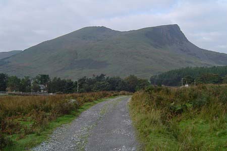
Yr Aran and Snowdon from Rhyd-Ddu
Snowdonia/Eryri Walk
Nat Park - Snowdonia - Snowdon Crib Goch
County/Area - Gwynedd
Author - Peter Lane
Length - 8.5 miles / 13.8 km Ascent - 3700 feet / 1121 metres
Time - 8 hours 0 minutes Grade - mod/hard
Maps 

| Ordnance Survey Explorer OL17 | Sheet Map | 1:25k | BUY |
| Anquet OS Explorer OL17 | Digital Map | 1:25k | BUY |
| Ordnance Survey Landranger 115 | Sheet Map | 1:50k | BUY |
| Anquet OS Landranger 115 | Digital Map | 1:50k | BUY |
Walk Route Description
Click image to visit gallery of 12 images.
This Snowdonia walk (Eryri) visits the isolated summit of Yr Aran which, although absent from the exalted list of 3,000 foot peaks in Snowdonia, more than makes up for its isolation and lack of stature with its spectacular views. Enjoy a great panorama across to Y Lliwedd and the Watkins path. The route then continues with an excellent ridge walk via Bwlch Main to Snowdon itself. The walk is rounded off with a full descent of the well marked and well maintained Rhyd Ddu path.
Start at the Rhyd Ddu car park at SH571526 on the A4085 from Beddgelert to Caernarfon. Cross the light railway and follow the well defined Rhyd Ddu path generally East until it comes to a crossing point and heads off North East to Snowdon. Ignore this (noting that it is your return point after conquering Snowdon) and continue on the Eastward path. Coming to a small lake, quarry workings and mine works at Bwlch Cwm Llan.
Cross a wall and keeping it to your right follow it over some very wet ground, initially. Eventually you will climb to a ridge facing the Watkins path far below, looking East. Here turn right upwards to the summit. Take time to enjoy the glorious views from the summit cairn, you're unlikely to meet anyone else there!
Retrace to Bwlch Cwm Llan and then head up due North on the long ridge to Bwlch Main and Snowdon. This is a spectacular (and strenuous!) route, but is rewarded by incredible views to Y Lliwedd to the East. The final section of the climb at Bwlch Main meets the Rhyd Ddu path feeding in from the left and passes over a short knife edge arrete which, although not as airy as Crib Goch, provides a taster of the "daddy" of the genre. The path is quite safe and adequately wide, with plenty of room for people to pass.
Continue up to Snowdon "via the back door" as it were, arriving at the concrete pad behind the cafe. Mingle with the masses and then retrace to Bwlch Main and the Rhyd Ddu path that you will have noticed feeding in on the ascent. Follow this well defined route down towards the shapely Llechog cliffs below, the path marked by numerous cairns to continue down to the pastures below over a paved route. Finally retrace your steps at the first junction back to the car park.
Other walks nearby
| Walk 3613 | Moel Cynghorion from Llyn Cwellyn | moderate | 5.0 miles |
| Walk 3060 | Moel Lefn & Moel yr Ogof | moderate | 7.0 miles |
| Walk 2150 | Llyn Dinas and Cwm Bychan from Beddgelert | easy/mod | 6.0 miles |
| Walk 2560 | Moel Hebog, Moel yr Ogof & Moel Lefn from Beddgelert | mod/hard | 6.5 miles |
| Walk 1799 | Moel Hebog | moderate | 5.5 miles |
| Walk 1988 | Beddgelert, Moel Hebog, Meol yr Ogof & Moel Lefn | mod/hard | 6.8 miles |
| Walk 3074 | Mynydd Sygun | moderate | 4.5 miles |
| Walk 3231 | Moel Hebog, Meol yr Ogof and Moel Lefn from Beddgelert | mod/hard | 6.8 miles |
| Walk 1426 | Aberglaslyn and Cwm Bychan | easy/mod | 5.8 miles |
| Walk 1427 | Craflwyn circular from near Beddgelert | easy/mod | 2.5 miles |
Recommended Books & eBooks
Snowdonia: 30 Low-level and easy walks - North
 Guidebook describing 30 walks in Snowdonia, Wales. Routes are mostly low level and on clear paths and showcase the region's beautiful scenery and rich history and culture. Part of a 2-volume set, this northern volume includes the Snowdon area, the Ogwen and Conwy Valleys, Betws-y-Coed, Beddgelert, Ffestiniog and the coast.
More information
Snowdonia: 30 Low-level and easy walks - South
 Guidebook describing 30 walks in Snowdonia, Wales. Routes are mostly low level and on clear paths and showcase the region's beautiful scenery and rich history and culture. Part of a 2-volume set, this southern volume includes Trawsfynydd, Bala, Dolgellau, Machynlleth, the Harlech Coast and the valleys of the Mawddach and Dyfi.
More information
Messaging & Social Media
Message Walking Britain and follow the latest news.

Mountain Weather
Stay safe on the mountains with detailed weather forecasts - for iOS devices or for Android devices.