Llanddwyn Island from Newborough
Isle of Anglesey Walk
County/Area - Isle of Anglesey
Author - Lou Johnson
Length - 4.0 miles / 6.5 km Ascent - 100 feet / 30 metres
Time - 2 hours 10 minutes Grade - easy
Maps 

| Ordnance Survey Explorer 263 | Sheet Map | 1:25k | BUY |
| Anquet OS Explorer 263 | Digital Map | 1:25k | BUY |
| Ordnance Survey Landranger 114 | Sheet Map | 1:50k | BUY |
| Anquet OS Landranger 114 | Digital Map | 1:50k | BUY |
Walk Route Description
Click image to visit gallery of 6 images.
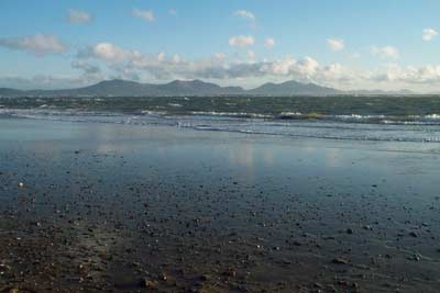
This easy walk offers some spectacular views of the mountains of Snowdonia (Eryri) and includes a mixture of interesting buildings and man-made features. In season there is added attraction that you will see varied bird life.
The start is the car park (grid ref. SH405633) which is reached from the village of Newborough on the A4080 road that runs from the Britannia Bridge towards Aberffraw on the west side of Anglesey.
From the car park walk down to the beach and turn right and continue west along the sand. Ahead you can see the rocky outline of Llanddwyn Island. The route is easy and reaching the island, follow the clear path that turns southwest. Note that at high tide access to the island may not be possible.
There are two main paths but both reach the end of the island and provide the basis for a circular walk. The island contains a number of points of interest including the remains of a church, a row of cottages once used by pilots guiding ships through the Menai Straits, a lighthouse, a large cross and a tower. Across the sea to the south there is a grand panorama including the Carneddau, the Glyders, Snowdon, the Nantlle Ridge and the Eifls.
Having enjoyed the views and inspected the man-made influences on the island head back to the car park, perhaps taking a different path to the one used for the outward route.
The best time to visit? Perhaps late afternoon or early evening allowing you to watch the sun set or during periods of heavy weather when it is possible to be surrounded by rough seas in relative safety.
Other walks nearby
| Walk 3373 | Foryd Bay | easy | 5.6 miles |
| Walk 1131 | Mynydd Mawr & Fron | easy/mod | 4.0 miles |
| Walk 3378 | Gyrn Goch, Gyrn Ddu & Bwlch Mawr | mod/hard | 6.5 miles |
| Walk 3117 | Garnedd Goch via Cwm Silyn (Two Lakes Walk) | moderate | 6.0 miles |
| Walk 3057 | Moel Eilio from Llanberis | moderate | 7.0 miles |
| Walk 3059 | Moel Cynghorion & Snowdon from near Llanberis | very hard | 13.5 miles |
| Walk 3613 | Moel Cynghorion from Llyn Cwellyn | moderate | 5.0 miles |
| Walk 2626 | Snowdon & Garnedd Ugain from Llanberis | moderate | 9.3 miles |
| Walk 1003 | Snowdon by the Llanberis Path | moderate | 9.0 miles |
| Walk 1681 | Moel Eilio & Moel Cynghorion from Llanberis | mod/hard | 10.0 miles |
Recommended Books & eBooks
No suggestions for this area.Messaging & Social Media
Message Walking Britain and follow the latest news.

Mountain Weather
Stay safe on the mountains with detailed weather forecasts - for iOS devices or for Android devices.