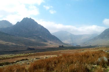
Pen yr Helgi Du from Ogwen Valley
Snowdonia/Eryri Walk
Nat Park - Snowdonia - Western Carneddau
County/Area - Conwy
Author - Lou Johnson
Length - 5.5 miles / 8.9 km Ascent - 1920 feet / 582 metres
Time - 4 hours 40 minutes Grade - moderate
Maps 

| Ordnance Survey Explorer OL17 | Sheet Map | 1:25k | BUY |
| Anquet OS Explorer OL17 | Digital Map | 1:25k | BUY |
| Ordnance Survey Landranger 115 | Sheet Map | 1:50k | BUY |
| Anquet OS Landranger 115 | Digital Map | 1:50k | BUY |
Walk Route Description
Click image to visit gallery of 5 images.
This is an ideal route for a half day excursion into the hills. The Carneddau are wild and desolate lying to the north of the A5 between Bethesda and Capel Curig. Limited parking is available at the entrance to the reservoir access road (Grid ref. SH687602) or if this is full then across the road Gwern Gof Isaf farm where a small charge is payable.
Walk up the reservoir access road climbing steadily for about 1.5 miles gaining nearly a thousand feet in the process. The road levels and drops down to Ffynnon Llugwy Reservoir, the shores of which make an ideal place to rest. Retrace you steps a short way to pick up the path that heads north along the eastern side of the reservoir. This path starts to climb up to the obvious col ahead. Zigzags at an easy gradient lead to the Col with the crags of Craig yr Isfa plunging into Cwm Eigiau far below.
At the Col turn right along a clear path. This climbs steeply through crags (with some scrambling) to lead you to the summit of Pen yr Helgi Du. The views are excellent in all directions with Carnedd Llewelyn, the highest point in the Carneddau, to the west.
Descend almost due south off the summit to follow a clear path that descends gently over a broad grassy ridge to reach a drainage channel (Grid ref. 700 607). Turn right along this channel to reach the outward route. Turn left and descend back to the start.
Other walks nearby
| Walk 1232 | Carnedd Llewelyn, Llyn Eigiau & Llyn Cowlyd | hard | 16.0 miles |
| Walk 2855 | Gallt yr Ogof & Braich y Ddeugwm | moderate | 4.0 miles |
| Walk 1150 | The High Carneddau | hard | 10.0 miles |
| Walk 1215 | Tryfan & Llyn Ogwen from Ogwen Valley | mod/hard | 5.5 miles |
| Walk 3001 | Tryfan North Ridge from Ogwen Valley | hard | 3.5 miles |
| Walk 3026 | Tryfan & the Eastern Tops from Ogwen Valley | hard | 5.8 miles |
| Walk 2820 | Carneddau traverse from Llyn Ogwen | mod/hard | 14.0 miles |
| Walk 2650 | Tryfan, the Glyders & Y Garn | very hard | 8.0 miles |
| Walk 3402 | Moel Siabod circular from Pont Cyfyng | moderate | 6.5 miles |
| Walk 1088 | Glyder Ridge traverse | hard | 5.5 miles |
Recommended Books & eBooks
Snowdonia: 30 Low-level and easy walks - North
 Guidebook describing 30 walks in Snowdonia, Wales. Routes are mostly low level and on clear paths and showcase the region's beautiful scenery and rich history and culture. Part of a 2-volume set, this northern volume includes the Snowdon area, the Ogwen and Conwy Valleys, Betws-y-Coed, Beddgelert, Ffestiniog and the coast.
More information
Snowdonia: 30 Low-level and easy walks - South
 Guidebook describing 30 walks in Snowdonia, Wales. Routes are mostly low level and on clear paths and showcase the region's beautiful scenery and rich history and culture. Part of a 2-volume set, this southern volume includes Trawsfynydd, Bala, Dolgellau, Machynlleth, the Harlech Coast and the valleys of the Mawddach and Dyfi.
More information
Messaging & Social Media
Message Walking Britain and follow the latest news.

Mountain Weather
Stay safe on the mountains with detailed weather forecasts - for iOS devices or for Android devices.