Titterstone Clee Hill and Catherton Common
Shropshire Hills Walk
Region - Shropshire Hills
County/Area - Shropshire
Author - Peter Lane
Length - 5.5 miles / 8.9 km Ascent - 1080 feet / 327 metres
Time - 3 hours 50 minutes Grade - easy/mod
Maps 

| Ordnance Survey Explorer 203 | Sheet Map | 1:25k | BUY |
| Anquet OS Explorer 203 | Digital Map | 1:25k | BUY |
| Ordnance Survey Landranger 138 | Sheet Map | 1:50k | BUY |
| Anquet OS Landranger 138 | Digital Map | 1:50k | BUY |
Walk Route Description
Click image to visit gallery of 6 images.
A short but moderately strenuous walk over barren heathland that takes full advantage of the new Access Land legislation. The grand finale is a full-on assault of Titterstone Clee Hill from the North. The lofty vantage point of Titterstone Clee hill affords distant views in all directions. Remaining on a high plateau for most of the walk, the views are not just restricted to the summit.
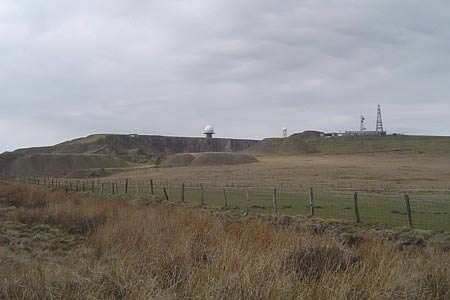
Titterstone Clee Hill has been defiled by extensive quarrying and bears the scars of its history. The summit is now the situation for the CAA to place various radar and microwave transmitters and receivers to provide air traffic control for the entire Midlands. Thus its natural features are further marred by an array of bizarre, giant golf ball like structures and the like. Despite this, it remains one of the highest peaks in Shropshire and can boast some of the most spectacular views, given its vantage point. This walk covers rough, sometimes boggy, exposed heath over some pathless terrain. Nonetheless, navigation under normal weather conditions is fairly easy for this route.
Start in the bowl carved out of the hill at a sharp hairpin bend in the road heading for the CAA tracking station, grid reference SO594775 where there is ample parking. The simplest route is to walk a short distance up the road to the tracking station and on the edge of the spoil heaps, look for the corner of the fence at SO599773. Take a bearing and then find a safe place to come off the spoil heap. Strike out towards this point using your right to roam. On reaching the fence, follow it South East over Clee Hill keeping it on your left until it rounds a corner and meets some genuine rights of way. Turn left along the broad bridlepath past Random Cottage and onwards as it curves slightly left past a pool. The path is never far from the fence on the left.
The views to the South are magnificent on a clear day. Follow the path as it descends onto Catherton Common and then disappears. Now use your right to roam and strike out across the Common. Try and keep the fence to the left within sight as this is the direction of travel. Cross a road and continue to follow the same fence line until a property ahead comes into sight. Trend to the right and keep the boundary of this property to the left. This will take you in between two fenced properties as you go round. Descend to Crumps Brook and rising the other side a clear path climbs and turns gently left to bring you up to a wide track. The onward bridlepath (not waymarked) is almost directly opposite, heading uphill to Silvington Common.
Past Rabbithouse Covert, a small wood on the right, the path meets the Jack Mytton Way at a crossroads. Straight ahead there are excellent views of Brown Clee Hill. Turn left along the broad Jack Mytton Way and then, at a road, turn right into the quaint little village of Cleeton St Mary. Pass the Church and continue on the road to a cattle grid where the Jack Mytton Way is marked as a Bridlepath heading towards Titterstone Clee Hill on the left.
Now you are spoilt for choice! Use whatever route you like to summit Titterstone Clee Hill. The massive golf ball like structure on the summit is as good a target as any to head for. If you do, you will find a discernible path on the ground that will take you most of the way up. Once on the summit, turn right away from the "hardware" and contour around to the "Giant's Chair" rock outcrop. From here move on to the trig point, enjoying the panoramic views out to Wales.
Once you've had enough of exploring this unusual summit, there are several return options. The simplest and safest is to follow the tarmac road past the radar station. My preferred route is to continue skirting around the summit anti-clockwise keeping relatively close to the precipice. You will see the car park below. After a few hundred metres the hillside drops down towards a small pool, taking a short-cut missing out the radar station and leading swiftly back to the car park.
Other walks nearby
| Walk 2654 | Titterstone Clee Hill & Cleeton St. Mary from Cleehill | moderate | 7.5 miles |
| Walk 2633 | Brown Clee Hill | easy/mod | 6.3 miles |
| Walk 3442 | Haws Hill from Tenbury Wells | easy/mod | 6.6 miles |
| Walk 2345 | Clee Hills | easy/mod | 6.8 miles |
| Walk 2296 | Brown Clee Hill Circular | easy/mod | 4.5 miles |
| Walk 3221 | High Vinnalls, Burrington, & Richard's Castle | mod/hard | 11.0 miles |
| Walk 2840 | High Vinnals & Richard's Castle | easy/mod | 6.0 miles |
| Walk 2248 | Wimperhill Wood and Longdon Orchard, Wyre Forest | easy | 4.0 miles |
| Walk 2022 | Wenlock Edge & Aston Munslow | moderate | 7.8 miles |
| Walk 2678 | Wenlock Edge & Broadstone from Wilderhope Manor | easy/mod | 6.4 miles |
Recommended Books & eBooks
Hillwalking in Shropshire
 Guidebook to 32 walking routes in Shropshire in the West Midlands. The routes range from 3 miles (5km) to 12 miles (19km), taking in highlights such as The Wrekin, Wenlock Edge, Long Mynd and Stiperstones, Castle Ring and Bury Ditches. Many routes start near delightful towns and villages including Church Stretton, Ludlow and Bishops Castle.
More information
Messaging & Social Media
Message Walking Britain and follow the latest news.

Mountain Weather
Stay safe on the mountains with detailed weather forecasts - for iOS devices or for Android devices.