Ham Woods, Croscombe & Knowle Hill from Shepton Mallet
Somerset Walk
County/Area - Somerset
Author - Anthony Maries
Length - 7.5 miles / 12.2 km Ascent - 1075 feet / 326 metres
Time - 4 hours 50 minutes Grade - easy/mod
Maps 

| Ordnance Survey Explorer 142 | Sheet Map | 1:25k | BUY |
| Anquet OS Explorer 142 | Digital Map | 1:25k | BUY |
| Ordnance Survey Landranger 183 | Sheet Map | 1:50k | BUY |
| Anquet OS Landranger 183 | Digital Map | 1:50k | BUY |
Walk Route Description
Click image to visit gallery of 5 images.
This walk explores the hilly area between Croscombe and Shepton Mallet. It starts from the Horseshoe pub at Bowlish (grid ref. ST612440), currently closed but shortly to reopen under new management (August 2008). On the walk, there are two pubs in Croscombe, the George and the Bull Terrier (the latter only open in the evening). The shop in the village also does off sales of Heck's, a highly recommended local brew, although the 2l containers it comes in are a little too large for most people's rucksacks. Sit behind a haystack and enjoy, you won't even remember the second half of the walk. Although the first half of this walk is much easier than it used to be, walkers are still advised to leave their Rohans at home and wear something more reliably thorn resistant.
From the Horseshoe, walk up Forum Lane for 50m and turn left into Ham Lane. Walk along this lane for 250m then fork left into Back Lane, a thoroughfare of Devonian steepness and narrowness. This lane takes you steeply downhill to meet the A371 from Shepton to Wells at Darshill (grid ref. ST605438). There are many interesting and attractive old cottages down this lane. One or two boast quaintly punning names which reach Acacia Avenue levels of dubious taste. At the bottom of the hill join the A371 and walk down the pavement on the right hand side for 250m.
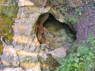
At Darshill Farm, follow the footpath on the right (grid ref. ST603439). This path goes round the back of the sewage works and quite steeply up hill through Darshill Wood. The woods are especially worth visiting in the spring, before the tree canopy shades out the light. Quite near the top of the hill, just off to the right there is Nancy Camel's cave. Nobody seems to know who Nancy Camel was, but it is easy to imagine some unfortunate old woman from a bygone century living here, gap-toothed and filthy from wood smoke, scratching out a bare living from a narrow slit in the rocks. When I first heard about the cave, it was extremely difficult to find. The path was marked on the map but there was no sign of it on the ground and the only way through was to wear thick clothing and crash through dense thickets of brambles. However, most of the brambles have now been cleared away, and the path is now quite easy to follow. There are even steps on the steep bits and a new stile at the top.
Cross the stile and walk up Ham Lane to Ham Western Farm (grid ref. ST602444). All three roads from the junction at the farm are Ham Lane. This is typical local eccentricity as regards road naming and numbering. My own house, not too far from the start of this walk, is numbered 3. Number 4 is between 3 and 2.
Continue up the 'northern' Ham Lane. The certifiably insane may insist on following the official line of the path, by climbing over barbed wire at the back of a barn, then wading over a house-sized mound of well-rotted dung. Most people will prefer to continue up the lane to an iron gate at the end of the first field, then left down the track which follows the northern edge of the field At the north western edge of the field, go through the gate and across a much smaller field and over a stone stile into Ham Woods. The 'official' line follows a steep and muddy path north-east down the side of the hill to come out at a track at the bottom, near a large yew tree.
Turn right here and follow the stony track through the heart of Ham Woods. The woods disguise the steepness and narrowness of this valley, probably formed in the Ice Ages by melt water running off the snow cap on the Mendips in spring, similar to Cheddar Gorge. Presently the track opens out into the abandoned Windsor Hill quarry. A magnificent viaduct and the remains of the former sidings on the former Somerset and Dorset Railway, loading bays and stone crushers can all be seen. The remains of several wrecked cars can also be found. The vintage of these vehicles, of models long vanished from the roads, and the size of the trees which have grown up around the remains, suggests that the teenage tearaways who left them there grew up a long time ago. They might even be almost old enough to join the RA, tut-tutting and cluck-clucking as they pass along their way, grumbling about the way other people treat the countryside.
The track peters out into a muddy path, ripe in spring with the smell of wild garlic. By a trickle of a stream there is a signpost. Bear left and up the hill (signposted to Wells). At the top of the hill you come to a stone stile at the western edge of the woods. Cross three fields. At the edge of the fourth the path turns away from the edge of the woods and strikes diagonally across three small fields to reach Thrupe Lane at a stone stile (grid ref. ST599452). Walk south west along the lane for 150m then right onto a path across a field by a tumbledown barn. At the far side of the field bear left onto West Lane (grid ref. ST596452). Initially the lane is a mere couple of ruts in the ground between hedges. As you go down hill towards Croscombe the track gradually improves and finally becomes a metalled road near the edge of the village.
Croscombe boasts many interesting old buildings. The ones most worth looking out for are Higher Mill, Croscombe Old Hall, and the former wool mill chimney, surrounded by trees, the buildings it provided power for long gone. From the shallow s-bend in the middle of the village by the George Inn, take the right hand fork of the two lanes starting on the south side of the main road, by the chapel. Walk quite steeply up hill for 150m, then turn into the drive of a cottage on the left hand side of the road. Follow the footpath which starts at the far end of the drive (grid ref. ST587442) and continue much more steeply up hill. After about 200m you reach a rough and narrow stony track. Bear left here and continue another 200m until you reach the top of Duncart Lane, by the small reservoir which feeds the village of Croscombe. Turn right here and continue for 100m until you reach the Old Wells Road, which follows the crest of the hill.
Follow the left hand of the two footpaths, which converge on the other side of the road junction, and walk in a southbound direction for 200m until you reach Dungeon Farm (grid ref. ST590435). Turn left after passing a large chicken shed to join the main track to the farm. At the end of the farm buildings leave the track for a footpath, which crosses a small field and under a disused railway (the former Great Western branch from Witham Friary to Wells). Cross the large field on the other side of the railway, walking south to reach a stone stile on the south eastern boundary of the field. The path across the next field skirts the side of the Friar's Oven. The hill is a Site of Special Scientific Interest.
The top of the hill provides extensive views towards Glastonbury Tor and across the Somerset Levels. Continue in a SSE direction downhill, crossing two more fields to meet another footpath (grid ref. ST592427) on the south side of Knowle Hill. Bear right and continue downhill in a SSW direction along the right hand side of a long narrow field until you reach a gate, which opens onto the bend of a narrow lane.
Turn left into the lane and follow it as it curves around the bottom of Knowle Hill. After 500m fork right into Mill Lane (grid ref. ST596426), a rough track, and follow the track to where it meets the Ridge Road. Bear left here and after 80m right down the track leading north west towards Shepton. After two fields where the track swings to the south east (grid ref. ST604431), continue in the south east direction to where it joins the track bed of the old Great Western Railway and onto the B3136 on the outskirts of Shepton.
Walk past the football ground and the junction of the Old Wells Road, then fork left at the King William pub. The former workhouse, one of the grandest of the many Victorian buildings in the town, is just off to the left, now transformed into luxury apartments. Turn left and walk down Coombe Lane which contains a number of quaint old cottages and an impressive former silk mill, to arrive back at the starting point of the walk near the Horseshoe Inn.
Other walks nearby
| Walk 2103 | Shepton Mallet and the Fosse Way | easy/mod | 7.5 miles |
| Walk 3499 | West Compton & North Wootton from Pilton | easy/mod | 7.5 miles |
| Walk 3304 | Pennard Hill from Pylle | moderate | 10.0 miles |
| Walk 1346 | Priddy, Ebbor Gorge & Wookey Hole from Wells | moderate | 13.5 miles |
| Walk 2201 | Historic Wells Circular | easy | 1.5 miles |
| Walk 1275 | Wells, North Wootton & Worminster | moderate | 9.5 miles |
| Walk 2172 | Ebbor Gorge & Priddy from Wookey Hole | easy/mod | 6.3 miles |
| Walk 2184 | Ebbor Gorge from Wookey Hole | easy/mod | 3.0 miles |
| Walk 3332 | Cameley & Hinton Blewett from Litton | easy | 5.6 miles |
| Walk 1212 | Glastonbury Tor | easy | 2.5 miles |
Recommended Books & eBooks
No suggestions for this area.Messaging & Social Media
Message Walking Britain and follow the latest news.

Mountain Weather
Stay safe on the mountains with detailed weather forecasts - for iOS devices or for Android devices.