Walk 1025 - printer friendly version
Farleigh Wallop and Ellisfield Walk
Author - Peter Lane & Paul Nunne
Length - 6.5 miles / 10.6 km
Ascent - 550 feet / 167 metres
Grade - easy/mod
Start - OS grid reference SU634483
Lat 51.230375 + Long -1.0933716
Postcode RG25 2QU (approx. location only)
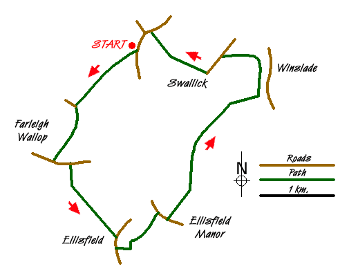
An appealing walk over rolling hills with expansive views and much rural charm. There are a number of fine flint churches along the route as well as the Fox pub at Ellisfield to enjoy as well as the scenery. With the walk sitting mainly between the 150 and 200m contours, this is a high level walk for Hampshire!
The walk commences at the car park near Cliddesden school, grid reference SU634483. Be mindful of parents and staff needing to park directly opposite the school in daytime; there is an alternative parking area near the junction with the school providing additional parking if required.
The start point itself is worthy of spending a few moments at in taking in the view of rolling hills before setting off. When ready, walk past the school. The tarmac runs out into an enclosed green lane (muddy at times) and continues for some distance to the church at Broadmere. After taking in the ambience of this rural flinty house of worship, continue south on the green lane until it reaches farm buildings and the hamlet of Farleigh Wallop.
Turn left along the country lane past a lovely brick and flint house and round a corner until the road begins to run downhill out of the hamlet. After 100metres or so going downhill, locate a footpath heading for Bedlam on the right. Drop down to the thatched cottages at Bedlam and a few metres past them, look for a footpath running uphill to a wood on the left. Enter the wood and continue along the right of way in between conservation areas. When the woods end, continue downhill until the path reaches a country lane.
Head right (downhill) on the country lane to the Fox pub at Ellisfield. The onward footpath is opposite the pub on the left. Head diagonally across the field aiming for the northwest corner of Park Field Copse. Take the footpath along the north flank of the copse through a couple of fences when the path heads diagonally left across a field towards Ellisford church. This fine flint church boasts an avenue of trees along its approaching path. Leaving this picturesque spot, continue right along the lane past the church and within 100 metres take a bridlepath on the left (Alley Lane) that becomes enclosed on both sides. Follow this for about 2km past Allwood Copse and Whinkney's Copse (where the path becomes a little more substantial) until it reaches an old railway bridge.
Head left past a disused chapel towards a steep embankment that mounts up to the disused railway. Turn left along the railway route, a permissive bridlepath. Follow this till it reaches a country lane and turn left past Swallick Farm. At the end of the farm buildings turn right along a broad track that affords superb views beyond the metropolis of Basingstoke. Upon reaching the road junction, turn left and return to the school in Cliddesden.
Messaging & Social Media
Message Walking Britain and follow the latest news.

Mountain Weather
Stay safe on the mountains with detailed weather forecasts - for iOS devices or for Android devices.