Walk 1224 - printer friendly version
Men-an-tol & Ding Dong Mine Walk
Author - Lou Johnson
Length - 3.0 miles / 4.9 km
Ascent - 360 feet / 109 metres
Grade - easy
Start - OS grid reference SW418344
Lat 50.153299 + Long -5.6159439
Postcode TR20 8NU (approx. location only)
Although only a short walk, this West Cornwall route is packed with interest. Besides the antiquities visited it also crosses some wild moorland country, which many people would not associate with Cornwall.
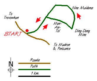
The start (Grid ref. SW418344) offers limited off-road parking alongside the minor road from Trevowhan to Madron and Penzance. After parking go through the gate on the eastern side of the road and follow the track northeast between walls for just under a kilometre. Take the footpath sign on your right and cross into a field to reach Men-an-tol a famous antiquity.
After inspecting these ancient stones continue southeast across open country to the engine house on the skyline. This is all that remains of Ding Dong Mine. The view is surprisingly good especially south over Mounts Bay. Like all mining areas there are many tracks and paths in the vicinity so precise navigation for the onward section is hard to describe. There is a ruined wall with a path alongside that leads northwards from Ding Dong mine to the southernmost of two 227 spot heights (Grid ref. 435350). However in summer the wall remains are hidden under vegetation and the path is well disguised by waist high ferns!
From this minor summit head north slightly downhill on a clear path to the Nine Maidens stone circle, which is located in a col. Well preserved this site represents the considerable extent of Neolithic habitation in Cornwall. Continue on the path northwards to the second summit where a standing stone is also of interest. The view north from here is interesting as the rocky summit of Carn Galver looks like a mini Tryfan.
Stay on the path descending west to rejoin the walled lane you used for the first part of the walk. Shortly after joining the lane there is the final antiquity of the walk located on your right - an inscribed stone in the middle of a field. This can be reached by crossing a stile. All that remains is to follow this back to the parking area.
Messaging & Social Media
Message Walking Britain and follow the latest news.

Mountain Weather
Stay safe on the mountains with detailed weather forecasts - for iOS devices or for Android devices.