Walk 1229 - printer friendly version
Helvellyn & Dollywaggon Pike from Wythburn Walk
Author - Lou Johnson
Length - 8.0 miles / 13 km
Ascent - 2870 feet / 870 metres
Grade - moderate
Start - OS grid reference NY324136
Lat 54.513175 + Long -3.0456649
Postcode CA12 4TP (approx. location only)
This Lake District walk to the summit of Helvellyn is straight forward with none of the challenges encountered when using an approach from Glenridding over Striding Edge. The whole route is on clearly marked paths although it must be remembered that with cloud sitting on the 'tops' then navigation skills would be required.
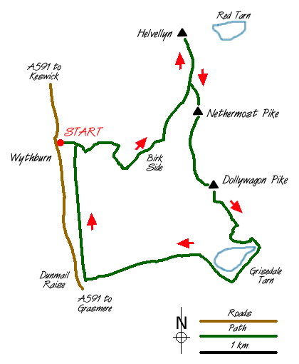
The start is the small car park adjacent to Wythburn Church (grid ref. NY324136) just off the A591 Grasmere to Keswick road. On busy days this is likely to fill early although there is other limited parking available in the vicinity. Exit the car park through the gate on the eastern side and follow the steep path up through the conifers. Reaching a cross track, which is used on the return, continue straight ahead continuing to climb.
Gaining height quickly you reach the open fell with the path visible up to your right. The path has been improved and after negotiating a series of zigzags you have completed the steepest part of the climb. It must be stressed that it is not a 'slog' as the surroundings are pleasant and the views improving as you climb. Ahead lies the most tedious section as you climb across Birk Side to the col between Nethermost Pike and Helvellyn. Reaching this col you get a great view of Striding Edge. The final climb to the summit of Helvellyn is straightforward and you are soon enjoying a 360 degree view.
From the summit of Helvellyn retrace your steps south to the col mentioned in the previous paragraph. Take the left fork ignoring the path used for the ascent and continue to the summit of Nethermost Pike. The preferred route is to ignore the main path, which takes a rather boring route, instead staying as close to the edge of the crags around Nethermost Cove. This route involves a little more ascent but the views are spectacular and worth the extra effort. From Nethermost Pike continue south over High Crag and onto the summit of Dollywaggon Pike where a promontory provides a grandstand view down Grisedale to Ullswater.
From Dollywaggon Pike the next objective is Grisedale Tarn. The path zigzags down the fellside losing nearly 1000 feet in the process. During the descent you get good views of St Sunday Crag, Fairfield and Cofa Pike. Reaching the Tarn cross the stepping stones across the outlet stream and climb south-westwards to Grisedale Hause. Turn right here following the path north-east to reach a minor col (grid ref. 344121). Staying on this path you descend to Dunmail Raise following Raise Back with its pretty waterfalls and cascades. Reaching the main road turn north and pick up the signed concession path that contours through fields to reach a conifer plantation (grid ref. 327125). Follow the forest track back to the start turning left on the path used for the outward route.
Messaging & Social Media
Message Walking Britain and follow the latest news.

Mountain Weather
Stay safe on the mountains with detailed weather forecasts - for iOS devices or for Android devices.