Walk 1233 - printer friendly version
Shining Tor & Windgather Rocks Walk
Author - Lou Johnson
Length - 7.5 miles / 12.2 km
Ascent - 1355 feet / 411 metres
Grade - moderate
Start - OS grid reference SJ975753
Lat 53.274677 + Long -2.0389492
Postcode SK10 5XL (approx. location only)
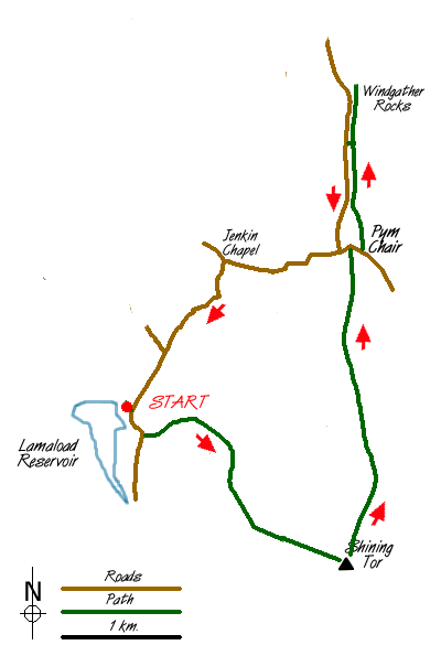
This Peak District walk on the western moors starts with a climb to the highest point in Cheshire and continues with a good ridge walk. It concludes with a section along the lanes with the opportunity to visit one of the more interesting churches in the area. The start is the small car park at Lamaload Reservoir (grid ref SJ975753). This can be reached down a lane from the A537 Buxton to Macclesfield road about 2 miles west of the "Cat & Fiddle". Please note that the car park at Lamaload reservoir, despite being an amenity provided by the National Park, is only available to the general public from 7th November to 30th April. At other times it is the exclusive preserve of an angling club, who keep the barrier locked. Some parking is available at the roadside.
Exit the car park and turn right along the lane in the direction of the A537. Where the lane bends right go through the gate on the left along a track signed to Shining Tor. This track/path climbs steadily and where it forks keep on the right-hand path, which climbs more steeply across rough pasture.
Stay with this path as it swings south to follow a wall on your right. The path descends gently and turns east before climbing again to reach the wall and the summit of Shining Tor. The view in all directions is good with many landmarks in evident. To the south you can see the Roaches and Shutlingsloe, whilst away to the northeast Mam Tor and Kinder Scout are in view. After taking in the view head north along the wall, which is to your left over the next lengthy section of ridge to Pym Chair. The ridge marks the boundary between Cheshire and Derbyshire and after a wet spell can be rather boggy so be prepared for a little bog trotting!
Reaching the road at Pym Chair, turn right for a short way before following the continuation of the ridge path northwards to Windgather Rocks. (Note - if you are short of time or energy then you may omit the next section and instead turn left along the road and follow the instructions further down the page). The path parallels the road and is often wet in which case it is better to walk on the road. Windgather Rocks offer a choice nursery routes and you will often see climbers enjoying the challenge. The grassy top also provides a pleasant place to stop for a break.
The route now retraces the route for some way and it is probably easier to use the road following it as far as a T-junction where you turn right. This lane descends to Jenkin Chapel with its interesting history and if you have time allow a few minutes here to investigate this rather utilitarian structure. Turn left at Jenkin Chapel and follow the lane back to the start.
Messaging & Social Media
Message Walking Britain and follow the latest news.

Mountain Weather
Stay safe on the mountains with detailed weather forecasts - for iOS devices or for Android devices.