Walk 1414 - printer friendly version
Barton and Barrow-on-Humber Walk
Author - Hugh Marrows
Length - 8.3 miles / 13.4 km
Ascent - 20 feet / 6 metres
Grade - easy/mod
Start - OS grid reference TA030234
Lat 53.696891 + Long -0.44144605
Postcode DN18 5BD (approx. location only)
Starting from the new nature reserve at Waters Edge in Barton this walk visits Barrow, the home of famous C18th clockmaker John Harrison and returns along the Humber bank. There are cafés at the Waters Edge and the nearby Ropewalk and two inns (off route) in Barrow. The Waters Edge visitor centre will provide a reserve map illustrating the various colour-coded routes within the reserve.
Barton has always depended upon the Humber and waterborne trade for its prosperity and its long history has resulted in a remarkable architectural legacy. The local clay was long exploited for brick and tile making and in the past this has also contributed much to the town's attractiveness.
Today the abandoned clay pits along the Humber on either side of town are used as nature reserves and for leisure activities such as sailing and fishing. The most recent reserve to open, the Waters Edge, occupies the site of an old chemical works whilst nearby are the picturesque wharves of the Haven and the amazing 450 yard long Ropewalk, built in 1767, which now houses art and craft galleries and a rope-making heritage display.
Nowadays Barrow does seem an unlikely place for ground breaking scientific progress. Yet it was here that John Harrison (1693 -1776) lived and devoted his life to the development of his famous seagoing clocks now preserved in Greenwich Observatory. (Born in Yorkshire Harrison's family moved here when he was very young, so Lincolnshire has made a claim to him too!) Because of the difficulties of keeping accurate time at sea, in 1714 the admiralty offered a prize (equivalent to a £ 1million) for the invention of an accurate sea-going clock. Harrison's struggle to solve the problem, and then to overcome the government's reluctance to pay up lasted until 1773. (Read all about it in Dava Sobell's book "Longitude") Holy Trinity church has a display featuring pictures of his clocks and a portrait copied from one in the Science Museum.
The nearby Barrow "Castles" (GR656225) are remnants of a medieval motte and bailey that was probably built around 1071AD; earthworks still rise to 3 metres or so, and are visible from the road.
After the walk spare time to look around Barton too with its narrow streets, delightful houses and shops. The town's best-known features are of course its two magnificent churches, St. Mary's and St. Peter's, cheek by jowl with only yards between them.
St. Mary's is a mix of architectural styles beginning around 1150 AD with many alterations and additions over the centuries whilst St Peter's is one of England's finest Saxon churches with a tower design characteristic of the mid C10th. Building in stone was still new then; look for the mitred stone joints adapted from woodworking techniques. St. Peter's is in the care of English Heritage. (Opening times are on their website.)
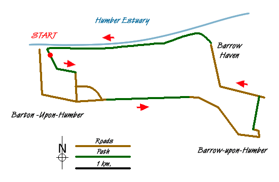
Route Guide
From the Waters Edge visitor centre follow the wooden walkway cantilevered out over the lagoon to a path junction and turn left and then right at the next junction. At a third path junction go left again past Folly Pond and at the next junction go right again and exits onto Pasture Road North. (Red route on the reserve map)
Turn right to cross the railway and at the junction of Falkland Way and Pasture Road keep ahead until opposite the end of Butts Road. Now turn left along Pasture Road South - a pedestrian/cycleway which rejoins Falkland Way. Cross onto the lane opposite where tarmac soon gives way to grass. Continue for about a mile and at a footpath sign, go through some trees to exit into a large field. Walk ahead beside the right hand hedge to join a road (West Marsh Lane) at a handgate.
Keep forward, bearing right at the first junction. At the second junction (with the B1402) cross to the pavement opposite, and go right for 100 yards before taking the footpath on the left along the edges of two fields. Then look for a grassy track between hedges that leads into Barrow. At a road continue until you can turn right through the churchyard. [You may wish to explore Barrow by strolling down to the Market Place and the inns.
Return through the churchyard and cross into North Street, go over Barton Road (the B1402) and continue along North Street until you can turn left into Cherry Lane, which becomes a short, unsurfaced track. At the end turn right to cross a footbridge and at the next road (Hann Lane) turn left. (Along here the "Castles" are on the left.) At the next junction bear right and keep ahead past the Haven Inn to Barrow Haven.
Turn left over the railway bridge, then immediately right onto the Humber Bank where a two-mile walk returns you to the Waters Edge centre with magnificent views across the Humber all the way.
Messaging & Social Media
Message Walking Britain and follow the latest news.

Mountain Weather
Stay safe on the mountains with detailed weather forecasts - for iOS devices or for Android devices.