Walk 1458 - printer friendly version
The Rossendale Way from Greave Walk
Author - Allan Friswell
Length - 7.0 miles / 11.4 km
Ascent - 600 feet / 182 metres
Grade - easy/mod
Start - OS grid reference SD876234
Lat 53.706877 + Long -2.1893247
Postcode OL13 9HA (approx. location only)
This is not a "pretty" walk. Rossendale generally presents a slightly stern face, of former quarries, mill stacks and grass-covered spoil heaps, although it is by no means unattractive in these weathered softened reminders of an industrial past. These apart, there are open moor and grasslands on this ramble, with a sculpture early on the Irwell Sculpture Trail. The path is generally very easy to follow. Greave, (or The Greave, as many locals have it), your starting point, is known purely for its pub; and in that its good reputation is assured.
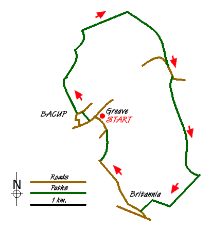
From the car parking space opposite the Crown pub you climb to the main road, cross, turn left, and 50 yards downhill turn right along a broad track. At the top of this lane turn left then right - this is the Irwell Sculpture trail which very shortly brings you to the Sentinel, a beehive of stone overlooking the valley, representing local traditions of drystoning and felting, though the eyes made from the latter and affixed to the original piece have long gone. The path exits in the near corner of the field, and then leads you to Old Meadow Farm which it passes through. At the fork keep left over a cattle grid. At the next farm follow the path around to the left and the rear of the house. Pass through two gates on the right. The path arrives at a T junction marked by a small pond and power pole, and you bear left.
After passing under the second set of power lines, where the track bears sharp left and there are signs of past quarrying, you make ahead and slightly right; and although the path isn't visible here just climb up to the ruins of an old barn - the very clear Rossendale Way runs behind it and you follow it right. Make your way to the farm house (wind turbines in attendance), go through the little gate on the left, turn right, and pass through the shambolic Heald Top Farmyard where you may well find small pigs running loose! The path goes on with no problems, crossing the track up to Todmorden Moor, and shortly brings you to the A681, which you go along to the left on the other side, eventually going right at a sharp left bend, over a cattle grid guarding a bridleway!
Shortly after this point the path splits. Take the right fork, and follow it uphill, going through the left of two gates (maintaining your line, still heading south). After the second gate/ stile bear right, keeping fairly close to the wall for around 1 1/2 miles. There is no obvious sign of any path for about half this distance and there are several boggy areas which could present serious crossing problems after heavy rain. The path is fairly clear during the second section. Keep following the wall. There are distant views of Stoodley Pike and Overden Moor wind farm on the left; to the right are some of the 29 turbines of Scout Moor above Rochdale, and behind to the right those of Dunnockshaw, just outside Burnley. You will pass two stiles, and after the second keep going ahead to reach the ladder stile (at SD 8960 2228).
After going over the Jacobs ladder, continue down hill, bear right, over the stile with no fence! Behind the farm building. The footpath leads back up the opposite hillside and across the field in to Green Brow.
Follow the track as it bears right, dropping away from the buildings of Green Brow, and reaching another track crossing at right angles, where you go left, going down towards the Rochdale Road and the extreme outskirts of Bacup at Britannia. Just before it, turn right along Tong Lane, which you follow for just over 1/4 mile, passing a school and under the smallest, tightest road bridge imaginable. After the phone mast, take the second of two footpath signs on the right and follow the track to a broad concreted roadway. Turn left down this towards some works, then almost at once take the path on the right which brings you to Warcock Lane. Right, then left into Oakenclough Road which leads you quickly back to the start.

Mountain Weather
Stay safe on the mountains with detailed weather forecasts - for iOS devices or for Android devices.

