Walk 1597 - printer friendly version
The White Horse & Sutton Poyntz from Osmington Walk
Author - Lou Johnson
Length - 4.0 miles / 6.5 km
Ascent - 900 feet / 273 metres
Grade - easy/mod
Start - OS grid reference SY724830
Lat 50.646026 + Long -2.391721
Postcode DT3 6EL (approx. location only)
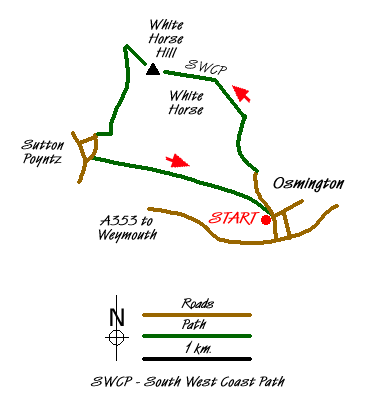
This short walk climbs onto White Horse Hill using the South West Coast Path (inland option). The White Horse can be seen on the hillside from the A353 and is popular landmark in the area. Grand views towards the sea are the reward for the climb. The route continues by visiting the village of Sutton Poyntz before returning across the fields to the start.
The village of Osmington lies to the north of the A353 east of Weymouth. The village offers limited parking near the church on the road leading north from the main road to Netherton Farm (Grid ref. SY724830). After parking descend this road and continue to Netherton Farm where the onward lane, the South West Coast Path inland route), leads you towards White Horse Hill. Initially the ascent is easy but there is a steeper section before you reach the top. During this ascent you can clearly see the White Horse to your left.
Reaching the top of the hill turn left and follow the clear path past the trig point to join a lane (Grid ref. SY710847). Go left onto the lane and immediately left again to follow a path descending around the side of Spring Bottom. Where the path splits take the right hand fork and continue across fields to a lane (Grid ref SY707839). Turn right onto a lane and follow it as it bends left into Sutton Poyntz. Continue past the pub and you are now in the centre of the village with an attractive stream flowing alongside the road.
Continue south on this road past Northdown Farm. Take the signed footpath on your left (Grid ref. SY706836). This leads across fields to a path junction (Grid ref. SY716834). Either option will take you to the road in Osmington Village. Turn right along the road and the church is a short way along on the right.
Messaging & Social Media
Message Walking Britain and follow the latest news.

Mountain Weather
Stay safe on the mountains with detailed weather forecasts - for iOS devices or for Android devices.