Walk 2013 - printer friendly version
The Plym Valley Walk
Author - John Paterson
Length - 5.0 miles / 8.1 km
Ascent - 300 feet / 91 metres
Grade - easy
Start - OS grid reference SX525587
Lat 50.409606 + Long -4.0771959
Postcode PL7 4SR (approx. location only)
Note: This walk can be combined with walks in Saltram Park and from Shaugh Bridge to give a walk up the full length of the Plym Valley. Details of the links to the adjacent walks are given in the text.
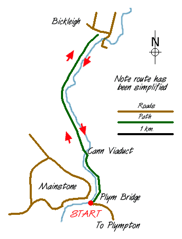
Plym Bridge (Grid Ref. SX525587) is a well known beauty spot on the North East fringe of Plymouth. The bridge is now closed to cars but is open to pedestrians and there are car parks on the West side (approached from Mainstone) and on the East side (approached from Plympton). From the Bridge, 3 routes start up the Plym valley: by the river bank, alongside a small disused canal and along the old railway bed (now a cycle track). This route combines each of these three routes to provide a varied and satisfying walk. It is described as starting from the East side of the bridge but walkers who park on the West side can simply walk 50 metres across the bridge to the start of the walk.
Keep a look out for the great variety archaeological remains and wild life on this walk. You have a good chance of seeing: foxes, squirrels, fallow deer, dippers, herons, kingfisher, buzzards and many of the woodland birds. You may also see adders in the drier sunny spots. Remember they are more scared of you than you are of them - give them a wide berth and they won't harm you.
From the Plym Bridge car park on the East side of the river cross the lane and take the gate under the disused railway bridge to gain access to the long disused canal towpath. Follow the towpath north with the canal on your right and the river on your left until you pass under the Cann viaduct after about one mile. Before climbing the steps up to the top of the viaduct take a look at the ruined quarry buildings and interpretation boards. The pool beyond the quarry buildings contains stickleback and is a favourite haunt of kingfishers.
Climb the steps to the top of the viaduct and then turn right to walk north along the old railway bed. Follow the railway bed for 1.5 miles passing over 2 more huge viaducts. There are opportunities to shorten the walk by escaping right at several points down to the river (over 100 feet below) or to take several paths to the left which enable you to extend the trip by exploring the woods. After 1.5 miles the track bed becomes impossible to follow further and you are forced to take a right fork for a few yards until you reach a seat and a signpost by a public road. This is Bickleigh station and is the far point of this walk (Note: you could continue to Shaugh Bridge by following the cyclists signposts on public roads for half a mile when you rejoin the railway track bed which can be followed for 1 mile to Shaugh Bridge) However, our route doubles back and plunges steeply downhill to join the river.
Follow the river down stream for 0.75 mile to a ford. (When the water level is low this ford can be crossed and Cann Wood can be explored.) Stay this side of the ford and follow the river down stream. After one mile the main track veers right but a weir can be heard ahead of you. Keep to the river bank to reach the weir and salmon ladder - a favourite fishing spot for herons. After the weir continue down stream passing under Cann Viaduct again and stick as far as possible to the river bank until forced to climb up to the highway at Plymbridge.
Links to adjacent walks:
1. From the car park on the East Side of Plym Bridge the cycle track can be followed South to reach Saltram Park (1.5 miles)
2. From Bickleigh the cycle track can be followed to reach Shaugh Bridge (1.5 miles) - See detailed description in text above.
Messaging & Social Media
Message Walking Britain and follow the latest news.

Mountain Weather
Stay safe on the mountains with detailed weather forecasts - for iOS devices or for Android devices.